
فایل:Pyrenees topographic map-fr.svg

فایلین اصلی (SVG فایلی، ۳٬۲۰۰ × ۱٬۹۰۰ پیکسئل، فایلین اؤلچوسو: ۶٫۳ مگابایت)
![]()
Detailed map of large dimension. For a better viewing, click on the link of the image above.
Carte détaillée de grande dimension. Pour une visualisation optimale, cliquer sur le lien de l'image ci-dessus.
قیساسی
| Description |
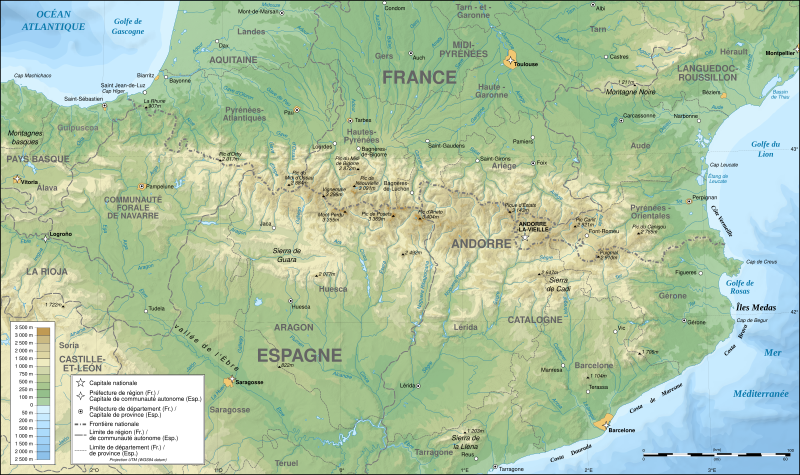
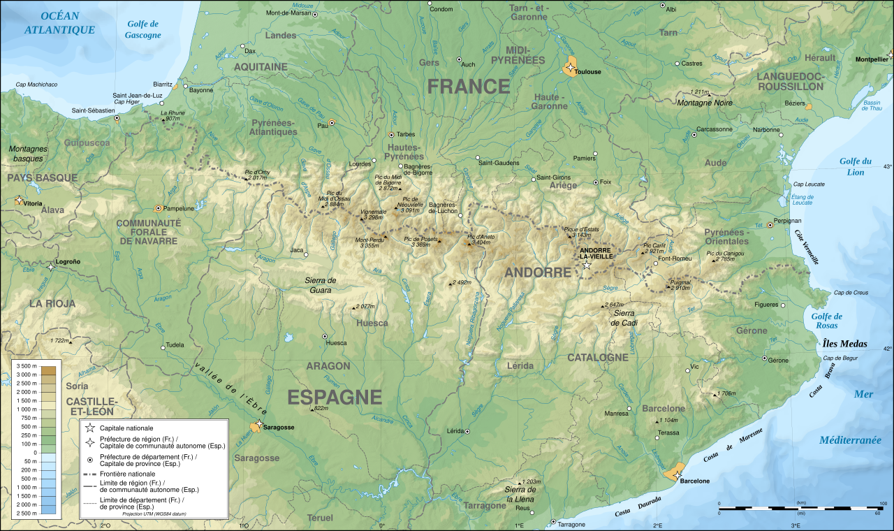
English: Topographic map in French of the Pyrenees mountains.
Note: The shaded relief is a raster image embedded in the SVG file. Français : Carte topographique des Pyrénées en francais.
Note : Le relief ombré est une image bitmap embarquée dans le fichier SVG. Português: Mapa topográfico (em Francês) dos Pirenéus.
Español: Mapa topográfico (en francés) de los Pirineos.
UTM projection; WGS84 datum; shaded relief (composite image of N-W, W and N lightning positions);
|
||
| SVG genesis | |||
| تاریخ | May 2007 (modified September 2008) | ||
| قایناق |
Own work;
|
||
| پدیدآورنده | |||
| ایجازه (فایلین تکرار ایستیفادهسی) |
|
||
| زمینمرجعسازی | اگر نامناسب بود لطفاً warp_status = skie را برای مخفیسازی تنظیم کنید. | ||
| آیری نوسخهلر |
[]
|


دستاوردها
|

This image was selected as picture of the day on Wikimedia Commons for 1 August 2007. It was captioned as follows: English: Topographic map in French of the Pyrenees mountains. Other languages:
Čeština: Francouzská mapa pohoří Pyreneje Dansk: Topografisk kort over Pyrenæerne på fransk. English: Topographic map in French of the Pyrenees mountains. Français : Carte topographique des Pyrénées en français. Magyar: A Pireneusok térképe Nederlands: Franse Topografische kaart van de Pyreneeën Português: Um mapa topográfico em francês, da região dos Pireneus. Română: Hartă topografică a munților Pirinei, Franța. Suomi: Topografinen kartta Ranskasta, Pyreneiden vuorilta. Svenska: Topografisk karta över Pyrenéerna på franska. Русский: Топографическая карта Пиренеев. Українська: Топографічна карта Піренеїв 中文: 法语注释的比利牛斯山地形图 中文(繁體): 庇里牛斯山的法語地形圖 עברית : מפה טופוגרפית בצרפתית של הרי הפירינאים |
لیسانس

|
اجازهٔ کپی، پخش و/یا تغییر این سند تحت شرایط مجوز مستندات آزاد گنو، نسخهٔ ۱٫۲ یا هر نسخهٔ بعدتری که توسط بنیاد نرمافزار آزاد منتشر شده؛ بدون بخشهای ناوردا (نامتغیر)، متون روی جلد، و متون پشت جلد، اعطا میشود. یک کپی از مجوز در بخشی تحت عنوان مجوز مستندات آزاد گنو ضمیمه شده است.
بو فایلین،
کوپیالانماسی، پایلانماسی و / و یا دییشدیریلمهسینه ایجازه وئریلمیشدیر. لیسئنزیانین بیر کوپیاسی،مجوز مستندات آزاد گنوباشلیقلی حیسهده ایشتیراک ائتمکدهدیر. |
| بو فایل کریتیو کامانز مجوز ایله Attribution-Share Alike 3.0 اویغونلاشمامیش یاییملانیبدیر. | ||
| ||
| این برچسب مجوز بهعنوان بخشی از روزآمدسازی مجوز GFDL، به این پرونده افزوده شد. |
- سیزین ایجازه نیز وار دیر:
- بؤلۆشمک – اثرین کپی، پایلاشماق و چاتدیرماسی اوچون
- تلفیق ائت – اثرین توتوشدورماسی اوچون
- آشاغی داکی شرایطله:
- تخصیص – اثری مؤلف و یا لیسئنزییالی طرفیندن گؤستریلدیی کیمی ایستیناد ائتملیسینیز (آنجاق سنی دستکلدیینی و یا اثردن ایستیفاده ائتمیینیزی تکلیف ائتمملیسینیز).
- بیرگه پایلاشیم – اگر بو اثرده دَییشدیرمه، چؤندرمه، یا دا کؤکدن دوزلتمه ائتسز، اله گلمیش اثری یالنیز بیر ائشیت یوخسا اوخشار بیر مجوزین آلتیندا یاییملایابیلرسینیز .
فايل گئچمیشی
فايلین اولکی وئرسیياسینی گؤرمک اۆچون گۆن/تاریخ بؤلمهسیندهکی تاریخلری تێقلايین.
| تاریخ/واخت | کیچیک عکس | اؤلچولر | ایشلدن | باخیش | |
|---|---|---|---|---|---|
| ایندیکی | ۱۴ دسامبر ۲۰۱۲، ساعت ۰۰:۰۵ | | ۳٬۲۰۰ در ۱٬۹۰۰ (۶٫۳ مگابایت) | Benh | uses Helvetica over Arial when available. |
| ۲۳ سپتامبر ۲۰۰۸، ساعت ۱۵:۴۹ |  | ۳٬۲۰۰ در ۱٬۹۰۰ (۶٫۳ مگابایت) | Sting | Using ETOPO1 data for bathymetry; new standard colors | |
| ۲ جولای ۲۰۰۷، ساعت ۰۰:۲۵ |  | ۳٬۲۰۰ در ۱٬۹۰۰ (۵٫۹ مگابایت) | Sting | + projection info in key ; + major cities areas ; some corrections in the rivers | |
| ۲۵ ژوئن ۲۰۰۷، ساعت ۲۰:۳۰ |  | ۳٬۲۰۰ در ۱٬۹۰۰ (۵٫۸۸ مگابایت) | Sting | + key for borders | |
| ۳۱ مئی ۲۰۰۷، ساعت ۲۱:۱۸ |  | ۳٬۲۰۰ در ۱٬۹۰۰ (۵٫۸۸ مگابایت) | Sting | Some corrections | |
| ۳۰ مئی ۲۰۰۷، ساعت ۱۸:۲۳ |  | ۳٬۲۰۰ در ۱٬۹۰۰ (۵٫۸۸ مگابایت) | Sting | {{Information |Description=Topographic map in French of the Pyrenees mountains |Source=Own work ;<br/>Topographic map : [http://www2.jpl.nasa.gov/srtm NASA Shuttle Radar Topography Mission] (SRTM3 v.2) (public domain) edited with [http:// |
فايل ایشلدمهسی
آشاغیداکی صحیفه بو فایلا باغلانیر
فایلین باشاباش ایشلنیلمهسی
بو فایل آشاغی داکی آیری ویکی لرده ایشلَنیر:
- af.wikipedia.org-ده ایشلنمهسی
- an.wikipedia.org-ده ایشلنمهسی
- ar.wikipedia.org-ده ایشلنمهسی
- ba.wikipedia.org-ده ایشلنمهسی
- bs.wikipedia.org-ده ایشلنمهسی
- ca.wikipedia.org-ده ایشلنمهسی
- cs.wikipedia.org-ده ایشلنمهسی
- en.wikipedia.org-ده ایشلنمهسی
- eo.wikipedia.org-ده ایشلنمهسی
- es.wikipedia.org-ده ایشلنمهسی
- et.wikipedia.org-ده ایشلنمهسی
- eu.wikipedia.org-ده ایشلنمهسی
- fa.wikipedia.org-ده ایشلنمهسی
- fi.wikipedia.org-ده ایشلنمهسی
- fr.wikipedia.org-ده ایشلنمهسی
- Ariège (département)
- Aude (département)
- Andorre
- Sentier de grande randonnée 10
- Haute-Garonne
- Hautes-Pyrénées
- Pyrénées-Atlantiques
- Pyrénées-Orientales
- Pyrénées
- Liste des communes des Hautes-Pyrénées
- Discussion:Liste des communes des Hautes-Pyrénées
- Pau
- Béarn
- Bayonne
- Tarbes
- Adour
- Ariège (rivière)
- Vals (Ariège)
- Catalogne
- Aragon (communauté autonome)
- Huesca
- Bizanos
- Pays basque
- Discussion:Béarn
- Discussion:Pau
- Val d'Aran
- Prades (Pyrénées-Orientales)
- Haute-Navarre
- Lugdunum Convenarum
- Lourdes
بو فایلینسراسری ایستفاده لرینه باخین.