دیهچین بؤلگهسی: نوسخهلر آراسینداکی فرق
محتوای حذفشده محتوای افزودهشده
4321bot (دانیشیق | چالیشمالار) ←top: چک شهرلری |
4321bot (دانیشیق | چالیشمالار) |
||
| خط ۱: | خط ۱: | ||
{{Infobox settlement|<!-- Basic info ---------------->|name =Děčín District|other_name =|native_name= Okres Děčín <!-- for cities whose native name is not in English -->|nickname=|settlement_type =[[Districts of the Czech Republic|District]]<!--For Town or Village (Leave blank for the default City)-->|motto=<!-- images and maps ----------->|image_skyline =Decin.JPG|imagesize = 300px|image_caption = [[Děčín Castle]] as seen from the Shepherd's Cliff|image_flag =|flag_size =|image_seal =|seal_size =|image_shield =|shield_size=|image_map = Map CZ - district Decin.PNG|mapsize = 300px|map_caption= District location in the [[ |
{{Infobox settlement|<!-- Basic info ---------------->|name =Děčín District|other_name =|native_name= Okres Děčín <!-- for cities whose native name is not in English -->|nickname=|settlement_type =[[Districts of the Czech Republic|District]]<!--For Town or Village (Leave blank for the default City)-->|motto=<!-- images and maps ----------->|image_skyline =Decin.JPG|imagesize = 300px|image_caption = [[Děčín Castle]] as seen from the Shepherd's Cliff|image_flag =|flag_size =|image_seal =|seal_size =|image_shield =|shield_size=|image_map = Map CZ - district Decin.PNG|mapsize = 300px|map_caption= District location in the [[مرکزی بوهم اوستانی]] within the [[Czech Republic]]|image_map1 = Decin District 2010 names DC CZ.png|mapsize1= 300px|map_caption1 = Municipalities of Děčín District<!-- Location ------------------>|subdivision_type = Country|subdivision_name = {{flag|Czech Republic}}|subdivision_type1= [[Regions of the Czech Republic|Region]]|subdivision_name1= [[منطقه اوستی ناد لابم]]|subdivision_type2=Capital|subdivision_name2=[[Děčín]]|subdivision_type3=|subdivision_name3=<!-- Politics ----------------->|government_footnotes=|government_type =|leader_title =|leader_name=|established_title= <!-- Settled -->|established_date =<!-- Area --------------------->|area_magnitude=|unit_pref =Metric <!--Enter: Imperial, if Imperial (metric) is desired-->|area_footnotes =|area_total_km2 =908.58<!-- ALL fields dealing with a measurements are subject to automatic unit conversion-->|area_land_km2= <!--See table @ Template:Infobox Settlement for details on automatic unit conversion-->|area_metro_km2 =<!-- Population----------------------->|population_as_of=2009|population_footnotes =|population_note =|population_total=136,621|population_density_km2=150<!-- General information --------------->|timezone= [[Central European Time|CET]]|utc_offset =+1|timezone_DST= [[Central European Summer Time|CEST]]|utc_offset_DST=+2|coordinates= |elevation_footnotes = <!--for references: use <ref> </ref> tags-->|elevation_m=|elevation_ft =<!-- Area/postal codes & others -------->|postal_code_type = <!-- enter ZIP code, Postcode, Post code, Postal code... -->|postal_code=|area_code =|blank_name =|blank_info =|blank1_name=|blank1_info=|website =|footnotes =}} |
||
[[بؤلمه:چک شهرلری]] |
[[بؤلمه:چک شهرلری]] |
||
۲۲ جولای ۲۰۱۸، ساعت ۱۷:۵۷ نوسخهسی
Děčín District
Okres Děčín | |
|---|---|
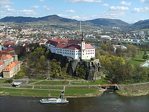
 Děčín Castle as seen from the Shepherd's Cliff | |
 District location in the مرکزی بوهم اوستانی within the Czech Republic | |
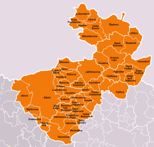
 Municipalities of Děčín District | |
| Country | |
| Region | منطقه اوستی ناد لابم |
| Capital | Děčín |
| اراضی | |
| • جمع | ۹۰۸٫۵۸ km2 (۳۵۰٫۸۰ sq mi) |
| جمعیت (2009) | |
| • جمع | ۱۳۶٬۶۲۱ |
| • سیخلیق | ۱۵۰/km2 (۴۰۰/sq mi) |
| ساعات قورشاغی | یوتیسی +1 (CET) |
| • یای (DST) | یوتیسی +2 (CEST) |
