بیکر، کالیفورنیا
Baker, California | |
|---|---|
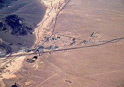
 Aerial view of Baker looking north: I-15 jogs south around the town, leaving Baker Boulevard, the main street, to show where the pre-interstate highway (US 91 and US 466) went. Baker Airport sits just north of the city alongside northbound CA 127, the "Death Valley Road". | |
| موختصاتلار: 35°16′33″N 116°03′57″W / 35.27583°N 116.06583°Wموختصات: 35°16′33″N 116°03′57″W / 35.27583°N 116.06583°W | |
| Country | |
| State | |
| County | San Bernardino |
| اراضی | |
| • جمع | ۲٫۶۹ sq mi (۶٫۹۶ km2) |
| • توپراق | ۲٫۶۹ sq mi (۶٫۹۶ km2) |
| • سو | ۰٫۰۰ sq mi (۰٫۰۰ km2) 0% |
| اوجالیق | ۹۴۲ ft (۲۸۷ m) |
| جمعیت (2010) | |
| • جمع | ۷۳۵ |
| • تخمین (2018) | ۸۳۵ |
| ساعات قورشاغی | یوتیسی -8 (Pacific) |
| • یای (DST) | یوتیسی -7 (PDT) |
| ZIP codes | 92309 |
| Area codes | 442/760 |
| FIPS code | 06-03512 |
| GNIS feature IDs | 238894, 2628708 |
| U.S. Geological Survey Geographic Names Information System: بیکر، کالیفورنیا | |
بیکر، کالیفورنیا (اینگیلیسجه:Baker, California ) آمریکا اؤلکهسینده بیر یاشاییش منطقهسیدیر. سوْن نۆفوس ساییمی اساسيندا ۷۳۵ نفر ایمیش و ۶٫۹۶ کیلومتر موربّع ساحهسی وار و کالیفورنیا ایالتینده یئرلشیب.
قایناقلار[دَییشدیر]
- ^ 2016 U.S. Gazetteer Files. United States Census Bureau. یوْخلانیلیبJul 19, 2017.
- ^ Baker Census Designated Place. United States Geological Survey. یوْخلانیلیبApril 8, 2015.
اینگیلیسجه ویکیپدیاسینین ایشلدنلری طرفیندن یارانمیش«Baker, California»، مقالهسیندن گؤتورولوبدور.( ۸ آقوست ۲۰۱۸ تاریخینده یوْخلانیلیبدیر).
| بو آمریکا مقاله، بیر قارالاما مقاله دیر. بونو گئنیشلندیرمکله ویکیپدیایا کؤمک ائده بیلرسینیز. |

