
فایل:1776 Rennell - Dury Wall Map of Bihar and Bengal, India - Geographicus - BaharBengal-dury-1776.jpg

فایلین اصلی (۹٬۱۰۶ × ۶٬۰۰۰ پیکسل, فایل اؤلچوسو: ۱۶٫۸۶ مگابایت, MIME نوعو: image/jpeg)
قیساسی
| هشدار | بعضی از مرورگرها با نمایش این تصویر با وضوح تصویر بالا مشکل دارند: این تصویر تعداد زیادی نقطه دارد و ممکن است به درستی در مرورگر شما بارگیری نشود یا باعث متوقف شدن مرورگر شما شود. |
|---|
| عنوان مقاله |
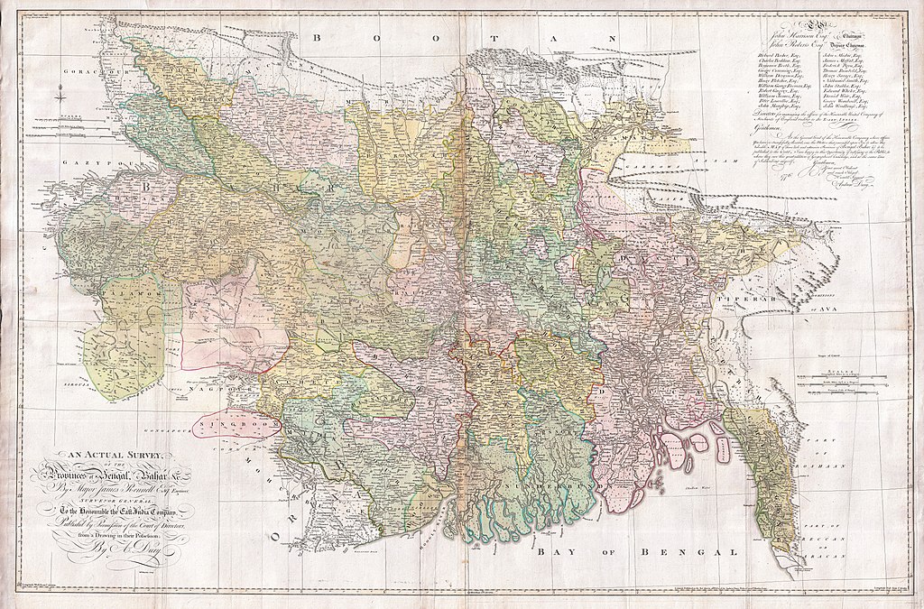
An Actual Survey, of the Provinces of Bengal, Bahar & c. by Major James Rennell Esq. Engineer to the Honorable the East India Company. Published by Permission of the Court of Directors from a Drawing in their Possession by A. Dury. |
|||||||||
| Description |
English: An altogether spectacular wall sized map of those parts of Bengal and Bihar, India. Follows the course of the Ganges River from Varanasi (Benares) eastward to the Ganges Delta and the Bay of Bengal. Includes Varanasi (Benares), Dacca (Dahka, Bengladesh), and Patna among many other important Indian cities. Bounded on the north by the Himalaya Mountains and the border with Bhutan. One of the first accurate maps of the interior of India. Laid out from primary surveys done by James Rennell, the first modern cartographer to map the interior of India. Notes cities, markets, battlefields, fortresses, roads, rivers, offers political commentary, and features some geographical references. Elaborate title in the lower left quadrant. Upper right quadrant features a dedication and letter of thanks written by Andrew Dury, the publisher, to the board of the East India Company. This is the first edition of this rare map – 1776 – as published by Dury. Later editions were published by Sayer and Bennet and by Laurie and Whittle.
Another high quality digitisation is available at the David Rumsey Historical Map Collection: [1] This map was published by Laurie and Whittle, as mentioned in the description by Geographicus for the 1776 map, in 1794. Regions are demarcated in coloured outlines instead of filled colours. A higher quality digitisation than that of Geographicus. Contains parts that are missing at the central vertical fold in the Geographicus digitisation of the 1776 map. Viewable in online Flash viewer and downloadable in MrSID format. |
|||||||||
| تاریخ | (dated) | |||||||||
| قایناق |
The Bengal Atlas ??, Rennell, James, (1779 first edition)
|
|||||||||
| پدیدآورنده | ||||||||||
| Geotemporal data | ||||||||||
| Bounding box |
|
|||||||||
| Georeferencing | ||||||||||
| Archival data | ||||||||||
| آیدی |
Geographicus link: BaharBengal-dury-1776 |
|||||||||
| اؤلچولر | بلندی: ۳۹٫۰ اینچ (۹۹٫۰ سانتیمتر)؛ عرض: ۵۹٫۰ اینچ (۱۴۹٫۸ سانتیمتر) | |||||||||

|
چنین ارزیابی شده که این نگاره، معیارهای نگارههای ارزشمند را داراست و به عنوان ارزشمندترین نگارهٔ ویکیانبار در مورد: Old maps of Bengal from 1776 by Major James Rennell در نظرگرفته شدهاست. شما میتوانید نامزد شدن آن را در اینجا ببنید. |
لیسانس
|
این اثر در کشورهایی و مناطقی که مدت زمان حق تکثیر، عمر پدیدآورنده بعلاوه 100 سال یا کمتر بعد از مرگ او است، در مالکیت عمومی قرار دارد. این اثر در ایالات متحده آمریکا در مالکیت عمومی قرار دارد به این دلیل که قبل از ۱ ژانویهٔ ۱۹۲۹ منتشر یا در ادارهٔ حق تکثیر آمریکا ثبت شدهاست. | |
| این پرونده تحت قانون حق تکثیر محدودیت آزاد منتشر شده که شامل تمامی حقوق مربوطه و حقوق نزدیک به آن میشود. | |
فايل گئچمیشی
فايلین اولکی وئرسیياسینی گؤرمک اۆچون گۆن/تاریخ بؤلمهسیندهکی تاریخلری تێقلايین.
| تاریخ/واخت | کیچیک عکس | اؤلچولر | ایشلدن | باخیش | |
|---|---|---|---|---|---|
| ایندیکی | ۱۷ مارس ۲۰۱۱، ساعت ۰۸:۳۹ | | ۹٬۱۰۶ در ۶٬۰۰۰ (۱۶٫۸۶ مگابایت) | BotMultichill | {{subst:User:Multichill/Geographicus |link=http://www.geographicus.com/P/AntiqueMap/BaharBengal-dury-1776 |product_name=1776 Rennell - Dury Wall Map of Bihar and Bengal, India |map_title=An Actual Survey, of the Provinces of Bengal, Bahar & c. by Major Ja |
فايل ایشلدمهسی
آشاغیداکی صحیفه بو فایلا باغلانیر
فایلین باشاباش ایشلنیلمهسی
بو فایل آشاغی داکی آیری ویکی لرده ایشلَنیر:
- ar.wikipedia.org-ده ایشلنمهسی
- as.wikipedia.org-ده ایشلنمهسی
- bn.wikipedia.org-ده ایشلنمهسی
- bn.wikisource.org-ده ایشلنمهسی
- cs.wikipedia.org-ده ایشلنمهسی
- el.wikipedia.org-ده ایشلنمهسی
- en.wikipedia.org-ده ایشلنمهسی
- es.wikipedia.org-ده ایشلنمهسی
- fa.wikipedia.org-ده ایشلنمهسی
- fr.wikipedia.org-ده ایشلنمهسی
- hi.wikipedia.org-ده ایشلنمهسی
- ja.wikipedia.org-ده ایشلنمهسی
- ko.wikipedia.org-ده ایشلنمهسی
- ml.wikipedia.org-ده ایشلنمهسی
- mt.wikipedia.org-ده ایشلنمهسی
- ne.wikipedia.org-ده ایشلنمهسی
- nl.wikipedia.org-ده ایشلنمهسی
- pnb.wikipedia.org-ده ایشلنمهسی
- sa.wikipedia.org-ده ایشلنمهسی
بو فایلینسراسری ایستفاده لرینه باخین.