
فایل:Approximate extension of Alodia based on accounts of Ibn Hawqal.png

سیناق گؤستریشی اؤلچوسو: ۸۰۰ × ۵۸۱ پیکسل. آیری کیفیتلر: ۳۲۰ × ۲۳۲ پیکسل | ۶۴۰ × ۴۶۴ پیکسل | ۸۱۳ × ۵۹۰ پیکسل.
فایلین اصلی (۸۱۳ × ۵۹۰ پیکسل, فایل اؤلچوسو: ۱۰۶ کیلوبایت, MIME نوعو: image/png)
قیساسی
| آچیقلاما |
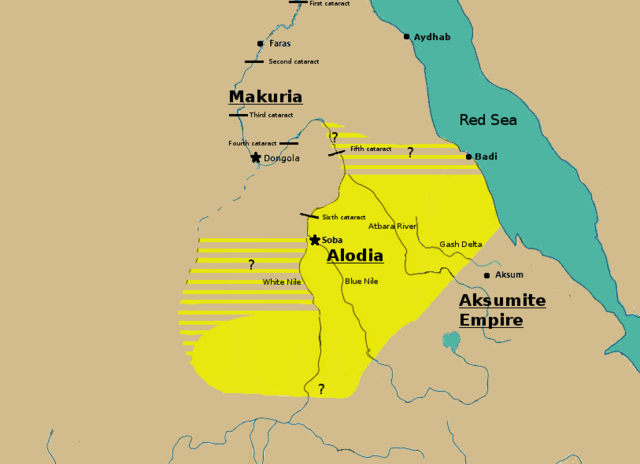
English: Initially based on map IX from the book "The Kingdom of Alwa" (see the first four versions of the map to see the faithful copy).[1] The original map had several problems, so I decided to modify it. 1) Zarroug had Alodia extend as far west as Darfur. However, there is still virtually no archaeological evidence supporting this assumption.[2] 2) The exact nothern border is still desputed; it is generally placed between Abu Hamad and the confluence of the Nile and the Atbara.[3] 3) Zarroug shows all regions west of the Nile as part of Alodia. However, the traveller Ibn Hawqal explicitly stated that parts of the region west of the White Nile were part of Makuria. The Nuba mountains were probably part of Alodia, hence I included stripes and a question mark for the area between the confluence of the two Niles and the Nuba mountains.[4] 4) There is little evidence that the Bayuda desert (between ed Debba and Omdurman) was part of either Makuria or Alodia.[5]
|
| تاریخ | |
| قایناق | یوکلهیهنین اؤز ایشی |
| یازار | LeGabrie |
لیسانس
من، صاحب حقوق قانونی این اثر، به این وسیله این اثر را تحث اجازهنامهٔ ذیل منتشر میکنم:
این پرونده تحت پروانهٔ Creative Commons Attribution-Share Alike 4.0 International منتشر شده است.
- سیزین ایجازه نیز وار دیر:
- بؤلۆشمک – اثرین کپی، پایلاشماق و چاتدیرماسی اوچون
- تلفیق ائت – اثرین توتوشدورماسی اوچون
- آشاغی داکی شرایطله:
- تخصیص – اثری مؤلف و یا لیسئنزییالی طرفیندن گؤستریلدیی کیمی ایستیناد ائتملیسینیز (آنجاق سنی دستکلدیینی و یا اثردن ایستیفاده ائتمیینیزی تکلیف ائتمملیسینیز).
- بیرگه پایلاشیم – اگر بو اثرده دَییشدیرمه، چؤندرمه، یا دا کؤکدن دوزلتمه ائتسز، اله گلمیش اثری یالنیز بیر ائشیت یوخسا اوخشار بیر مجوزین آلتیندا یاییملایابیلرسینیز .
فايل گئچمیشی
فايلین اولکی وئرسیياسینی گؤرمک اۆچون گۆن/تاریخ بؤلمهسیندهکی تاریخلری تێقلايین.
| تاریخ/واخت | کیچیک عکس | اؤلچولر | ایشلدن | باخیش | |
|---|---|---|---|---|---|
| ایندیکی | ۲۷ نوْوامبر ۲۰۱۸، ساعت ۱۵:۲۰ | | ۸۱۳ در ۵۹۰ (۱۰۶ کیلوبایت) | LeGabrie | Deleted stripes in Bayuda desert |
| ۲۸ اوْکتوبر ۲۰۱۸، ساعت ۱۵:۴۷ |  | ۷۰۳ در ۵۹۰ (۱۱۴ کیلوبایت) | LeGabrie | decreased width | |
| ۱۵ اوْکتوبر ۲۰۱۸، ساعت ۱۲:۵۱ |  | ۸۱۳ در ۵۹۰ (۱۰۸ کیلوبایت) | LeGabrie | Added Gash Delta | |
| ۲۹ سپتامبر ۲۰۱۸، ساعت ۱۱:۳۸ |  | ۸۱۳ در ۵۹۰ (۱۰۸ کیلوبایت) | LeGabrie | Extended the beams over the entire Bayuda | |
| ۴ سپتامبر ۲۰۱۸، ساعت ۱۲:۱۲ |  | ۸۱۳ در ۵۹۰ (۱۱۱ کیلوبایت) | LeGabrie | added question mark | |
| ۴ سپتامبر ۲۰۱۸، ساعت ۱۱:۵۹ |  | ۸۱۳ در ۵۹۰ (۱۰۸ کیلوبایت) | LeGabrie | Cut the beams in Darfur | |
| ۱ سپتامبر ۲۰۱۸، ساعت ۰۰:۵۵ |  | ۸۱۳ در ۵۹۰ (۱۱۴ کیلوبایت) | LeGabrie | Increased script size | |
| ۱ سپتامبر ۲۰۱۸، ساعت ۰۰:۵۱ |  | ۸۱۳ در ۵۹۰ (۱۱۴ کیلوبایت) | LeGabrie | small fix | |
| ۱ سپتامبر ۲۰۱۸، ساعت ۰۰:۴۹ |  | ۸۱۳ در ۵۹۰ (۱۱۴ کیلوبایت) | LeGabrie | Made it prettier | |
| ۱ فوریه ۲۰۱۸، ساعت ۲۱:۱۴ |  | ۸۱۳ در ۵۹۰ (۱۵۵ کیلوبایت) | LeGabrie | Added white beams and question marks to highlight the uncertainties of Zarroug's map. These uncertainties are: The extension into Darfur,the question of ownership of northern Kordofan and the beginning of Al-Abwab. The concrete amount of desert aside o... |
فايل ایشلدمهسی
آشاغیداکی صحیفه بو فایلا باغلانیر
فایلین باشاباش ایشلنیلمهسی
بو فایل آشاغی داکی آیری ویکی لرده ایشلَنیر:
- ar.wikipedia.org-ده ایشلنمهسی
- arz.wikipedia.org-ده ایشلنمهسی
- cs.wikipedia.org-ده ایشلنمهسی
- de.wikipedia.org-ده ایشلنمهسی
- en.wikipedia.org-ده ایشلنمهسی
- fa.wikipedia.org-ده ایشلنمهسی
- fi.wikipedia.org-ده ایشلنمهسی
- fr.wikipedia.org-ده ایشلنمهسی
- id.wikipedia.org-ده ایشلنمهسی
- ms.wikipedia.org-ده ایشلنمهسی
- nl.wikipedia.org-ده ایشلنمهسی
- pt.wikipedia.org-ده ایشلنمهسی
- ru.wikipedia.org-ده ایشلنمهسی
- sl.wikipedia.org-ده ایشلنمهسی
- sr.wikipedia.org-ده ایشلنمهسی
- sv.wikipedia.org-ده ایشلنمهسی
- ta.wikipedia.org-ده ایشلنمهسی
- th.wikipedia.org-ده ایشلنمهسی
- tl.wikipedia.org-ده ایشلنمهسی
- uk.wikipedia.org-ده ایشلنمهسی
- vi.wikipedia.org-ده ایشلنمهسی
- zh.wikipedia.org-ده ایشلنمهسی