
فایل:Bazentin le Petit 14 July 1916 map.png

فایلین اصلی (۱٬۰۰۰ × ۶۳۲ پیکسل, فایل اؤلچوسو: ۱۱۳ کیلوبایت, MIME نوعو: image/png)
قیساسی
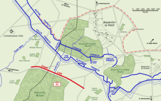
Map of Bazentin le Petit sector on the morning of 14 July 1916, Battle of Bazentin Ridge, showing the German second defensive position.
German trenches are shown in blue, including the communications trenches connecting to the (captured) first position. German barbed wire is shown as dotted blue lines. The start line of the assault brigades of the British 21st Division is shown in red. The position reached by the 21st Division and neighbouring 7th Division at 9 am is shown as the dashed red line.
Based on a trench map from the British Public Record Office.
| این اثر توسط پدیدآور آن، Gsl، به مالکیت عمومی درآمده است. این مربوط به تمام جهان است. در برخی از کشورها ممکن است به صورت قانونی این امکانپذیر نباشد؛ اگر چنین است: |
فايل گئچمیشی
فايلین اولکی وئرسیياسینی گؤرمک اۆچون گۆن/تاریخ بؤلمهسیندهکی تاریخلری تێقلايین.
| تاریخ/واخت | کیچیک عکس | اؤلچولر | ایشلدن | باخیش | |
|---|---|---|---|---|---|
| ایندیکی | ۲۱ اوْکتوبر ۲۰۰۵، ساعت ۱۰:۳۸ | | ۱٬۰۰۰ در ۶۳۲ (۱۱۳ کیلوبایت) | Igiveup | Map of Bazentin le Petit sector on the morning of 14 July 1916, Battle of Bazentin Ridge, showing the German second defensive position. German trenches are shown in blue, including the communications trenches connecting to the (captured) first position. |
فايل ایشلدمهسی
آشاغیداکی صحیفه بو فایلا باغلانیر
فایلین باشاباش ایشلنیلمهسی
بو فایل آشاغی داکی آیری ویکی لرده ایشلَنیر:
- af.wikipedia.org-ده ایشلنمهسی
- ca.wikipedia.org-ده ایشلنمهسی
- el.wikipedia.org-ده ایشلنمهسی
- en.wikipedia.org-ده ایشلنمهسی
- es.wikipedia.org-ده ایشلنمهسی
- fr.wikipedia.org-ده ایشلنمهسی
- hu.wikipedia.org-ده ایشلنمهسی
- id.wikipedia.org-ده ایشلنمهسی
- it.wikipedia.org-ده ایشلنمهسی
- lt.wikipedia.org-ده ایشلنمهسی
- no.wikipedia.org-ده ایشلنمهسی