
فایل:Civitas Londinium or The Agas Map of London.jpg

سیناق گؤستریشی اؤلچوسو: ۸۰۰ × ۳۳۸ پیکسل. آیری کیفیتلر: ۳۲۰ × ۱۳۵ پیکسل | ۶۴۰ × ۲۷۱ پیکسل | ۱٬۰۲۴ × ۴۳۳ پیکسل | ۱٬۲۸۰ × ۵۴۱ پیکسل | ۴٬۷۳۰ × ۲٬۰۰۰ پیکسل.
فایلین اصلی (۴٬۷۳۰ × ۲٬۰۰۰ پیکسل, فایل اؤلچوسو: ۴٫۰۸ مگابایت, MIME نوعو: image/jpeg)
قیساسی
| آچیقلاما |
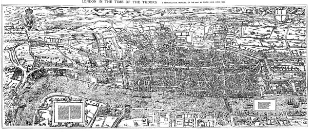
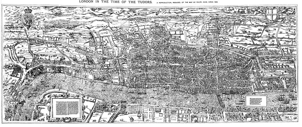
English: The earliest proper map (as opposed to panorama) of London known. Attributed to Ralph Agas, and probably surveyed between 1570 and 1605. The original was 6 foot 0.5 inches long by 2 feet 4.5 inches wide. This much reduced image is a scan of a copy of a lithograph of a copy, was itself badly repaired with sellotape and has had to be "restored"; so is hardly a truly faithful representation of the original, but few good copies exist and no other detailed public domain images are known. |
| تاریخ | |
| قایناق | Maps of Old London, London, Adam and Charles Black, 1908. Scanned & corrected Mike Calder. |
| یازار | Mike Calder, image of Civitas Londinium, Agas' Map of London, c. 1570-1605 |
| آیری نوسخهلر | آثار انشقاقی از این پرونده: Covent Garden from the Ralph Agas 1572 map of London.jpg |
لیسانس
|
این اثر در کشورهایی و مناطقی که مدت زمان حق تکثیر، عمر پدیدآورنده بعلاوه 100 سال یا کمتر بعد از مرگ او است، در مالکیت عمومی قرار دارد. | |
| این پرونده تحت قانون حق تکثیر محدودیت آزاد منتشر شده که شامل تمامی حقوق مربوطه و حقوق نزدیک به آن میشود. | |
فايل گئچمیشی
فايلین اولکی وئرسیياسینی گؤرمک اۆچون گۆن/تاریخ بؤلمهسیندهکی تاریخلری تێقلايین.
| تاریخ/واخت | کیچیک عکس | اؤلچولر | ایشلدن | باخیش | |
|---|---|---|---|---|---|
| ایندیکی | ۱۴ آقوست ۲۰۰۹، ساعت ۱۸:۵۹ | | ۴٬۷۳۰ در ۲٬۰۰۰ (۴٫۰۸ مگابایت) | MikeCalder | {{Information |Description={{en|1=The earliest proper map (as opposed to panorama) of London known. Attributed to Ralph Agas, and probably surveyed between 1570 and 1605. The original was 6 foot 0.5 inches long by 2 feet 4.5 inches wide. This much reduc |
فايل ایشلدمهسی
آشاغیداکی صحیفه بو فایلا باغلانیر
فایلین باشاباش ایشلنیلمهسی
بو فایل آشاغی داکی آیری ویکی لرده ایشلَنیر:
- af.wikipedia.org-ده ایشلنمهسی
- ar.wikipedia.org-ده ایشلنمهسی
- avk.wikipedia.org-ده ایشلنمهسی
- de.wikipedia.org-ده ایشلنمهسی
- el.wikipedia.org-ده ایشلنمهسی
- en.wikipedia.org-ده ایشلنمهسی
- es.wikipedia.org-ده ایشلنمهسی
- fa.wikipedia.org-ده ایشلنمهسی
- hy.wikipedia.org-ده ایشلنمهسی
- it.wikipedia.org-ده ایشلنمهسی
- ja.wikipedia.org-ده ایشلنمهسی
- ko.wikipedia.org-ده ایشلنمهسی
- la.wikipedia.org-ده ایشلنمهسی
- pt.wikipedia.org-ده ایشلنمهسی
- ro.wikipedia.org-ده ایشلنمهسی
- ru.wikipedia.org-ده ایشلنمهسی
- simple.wikipedia.org-ده ایشلنمهسی
- sl.wikipedia.org-ده ایشلنمهسی
- tr.wikipedia.org-ده ایشلنمهسی
- uk.wikipedia.org-ده ایشلنمهسی
- zh.wikipedia.org-ده ایشلنمهسی