
فایل:Historic American Buildings Survey W. N. Manning, Photographer, May 18, 1935 FRONT AND SIDE VIEW S. E. - Elmoreland, U.S. Highway 241, Glenville, Russell County, AL HABS ALA,57-GLENV,1-2.tif

حجم پیشنمایش JPG این TIF file:۸۰۰ × ۵۷۴ پیکسل آیری کیفیتلر: ۳۲۰ × ۲۲۹ پیکسل | ۶۴۰ × ۴۵۹ پیکسل | ۱٬۰۲۴ × ۷۳۴ پیکسل | ۱٬۲۸۰ × ۹۱۸ پیکسل | ۲٬۵۶۰ × ۱٬۸۳۶ پیکسل | ۵٬۰۰۰ × ۳٬۵۸۵ پیکسل.
فایلین اصلی (۵٬۰۰۰ × ۳٬۵۸۵ پیکسل, فایل اؤلچوسو: ۱۷٫۱ مگابایت, MIME نوعو: image/tiff)
قیساسی
| Historic American Buildings Survey W. N. Manning, Photographer, May 18, 1935 FRONT AND SIDE VIEW S. E. - Elmoreland, U.S. Highway 241, Glenville, Russell County, AL | ||||
|---|---|---|---|---|
| باشلیق |
Historic American Buildings Survey W. N. Manning, Photographer, May 18, 1935 FRONT AND SIDE VIEW S. E. - Elmoreland, U.S. Highway 241, Glenville, Russell County, AL |
|||
| محل کشیدهشده | Alabama; Russell County; Glenville | |||
| اؤلچولر | 5 x 7 in. | |||
| ایندیکی یئری |
Library of Congress Prints and Photographs Division Washington, D.C. 20540 USA http://hdl.loc.gov/loc.pnp/pp.print |
|||
| آیدی |
HABS ALA,57-GLENV,1-2 |
|||
| اعتبار خطی |
|
|||
| قایناق | https://www.loc.gov/pictures/item/al0711.photos.006540p | |||
| ایجازه (فایلین تکرار ایستیفادهسی) |
|
|||

| مختصات دوربین | | محل قرارگیری این نگاره و سایر نگارهها در: نقشهٔ شهری باز |
|---|
فايل گئچمیشی
فايلین اولکی وئرسیياسینی گؤرمک اۆچون گۆن/تاریخ بؤلمهسیندهکی تاریخلری تێقلايین.
| تاریخ/واخت | کیچیک عکس | اؤلچولر | ایشلدن | باخیش | |
|---|---|---|---|---|---|
| ایندیکی | ۲۹ ژوئن ۲۰۱۴، ساعت ۲۳:۴۶ | 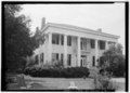 | ۵٬۰۰۰ در ۳٬۵۸۵ (۱۷٫۱ مگابایت) | Fæ | GWToolset: Creating mediafile for Fæ. HABS batch upload 29 June 2014 (101:150) |
فايل ایشلدمهسی
آشاغیداکی صحیفه بو فایلا باغلانیر
فایلین باشاباش ایشلنیلمهسی
بو فایل آشاغی داکی آیری ویکی لرده ایشلَنیر:
- en.wikipedia.org-ده ایشلنمهسی
- fa.wikipedia.org-ده ایشلنمهسی
- ur.wikipedia.org-ده ایشلنمهسی
- zh.wikipedia.org-ده ایشلنمهسی