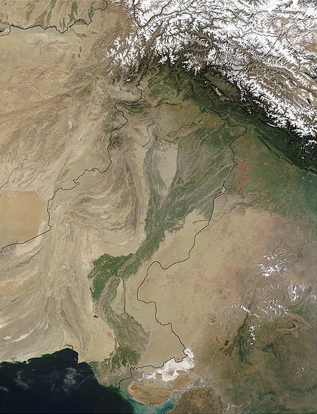
فایل:Indus.A2002274.0610.1km.jpg

سیناق گؤستریشی اؤلچوسو: ۴۵۸ × ۵۹۹ پیکسل. آیری کیفیتلر: ۱۸۳ × ۲۴۰ پیکسل | ۳۶۷ × ۴۸۰ پیکسل | ۵۸۷ × ۷۶۸ پیکسل | ۷۸۳ × ۱٬۰۲۴ پیکسل | ۱٬۳۰۰ × ۱٬۷۰۰ پیکسل.
فایلین اصلی (۱٬۳۰۰ × ۱٬۷۰۰ پیکسل, فایل اؤلچوسو: ۴۸۰ کیلوبایت, MIME نوعو: image/jpeg)
فايل گئچمیشی
فايلین اولکی وئرسیياسینی گؤرمک اۆچون گۆن/تاریخ بؤلمهسیندهکی تاریخلری تێقلايین.
| تاریخ/واخت | کیچیک عکس | اؤلچولر | ایشلدن | باخیش | |
|---|---|---|---|---|---|
| ایندیکی | ۲۸ مارس ۲۰۰۸، ساعت ۱۳:۰۳ |  | ۱٬۳۰۰ در ۱٬۷۰۰ (۴۸۰ کیلوبایت) | File Upload Bot (Magnus Manske) | {{BotMoveToCommons|en.wikipedia}} {{Information |Description={{en|en:Satellite image of the en:Indus River basin. Red dots indicate fires. International boundaries are superimposed; the boundary through en:Jammu and Kashmir reflects the [[ |
فايل ایشلدمهسی
آشاغیداکی صحیفه بو فایلا باغلانیر
فایلین باشاباش ایشلنیلمهسی
بو فایل آشاغی داکی آیری ویکی لرده ایشلَنیر:
- af.wikipedia.org-ده ایشلنمهسی
- ar.wikipedia.org-ده ایشلنمهسی
- arz.wikipedia.org-ده ایشلنمهسی
- ast.wikipedia.org-ده ایشلنمهسی
- as.wikipedia.org-ده ایشلنمهسی
- az.wikipedia.org-ده ایشلنمهسی
- ba.wikipedia.org-ده ایشلنمهسی
- be-tarask.wikipedia.org-ده ایشلنمهسی
- bh.wikipedia.org-ده ایشلنمهسی
- bn.wikipedia.org-ده ایشلنمهسی
- bo.wikipedia.org-ده ایشلنمهسی
- br.wikipedia.org-ده ایشلنمهسی
- bxr.wikipedia.org-ده ایشلنمهسی
- ca.wikipedia.org-ده ایشلنمهسی
- ceb.wikipedia.org-ده ایشلنمهسی
- ce.wikipedia.org-ده ایشلنمهسی
- ckb.wikipedia.org-ده ایشلنمهسی
- cy.wikipedia.org-ده ایشلنمهسی
- da.wikipedia.org-ده ایشلنمهسی
- en.wikipedia.org-ده ایشلنمهسی
- eo.wikipedia.org-ده ایشلنمهسی
- es.wikipedia.org-ده ایشلنمهسی
- fa.wikipedia.org-ده ایشلنمهسی
- fiu-vro.wikipedia.org-ده ایشلنمهسی
- gd.wikipedia.org-ده ایشلنمهسی
- gl.wikipedia.org-ده ایشلنمهسی
- hi.wikipedia.org-ده ایشلنمهسی
- hy.wikipedia.org-ده ایشلنمهسی
- ia.wikipedia.org-ده ایشلنمهسی
- id.wikipedia.org-ده ایشلنمهسی
- ilo.wikipedia.org-ده ایشلنمهسی
- incubator.wikimedia.org-ده ایشلنمهسی
- is.wikipedia.org-ده ایشلنمهسی
- it.wikipedia.org-ده ایشلنمهسی
بو فایلینسراسری ایستفاده لرینه باخین.


