
فایل:Lexington Concord Siege of Boston.jpg
فایلین اصلی (۳٬۲۱۱ × ۲٬۴۷۶ پیکسل, فایل اؤلچوسو: ۱٫۵۵ مگابایت, MIME نوعو: image/jpeg)
قیساسی
| آچیقلاما |
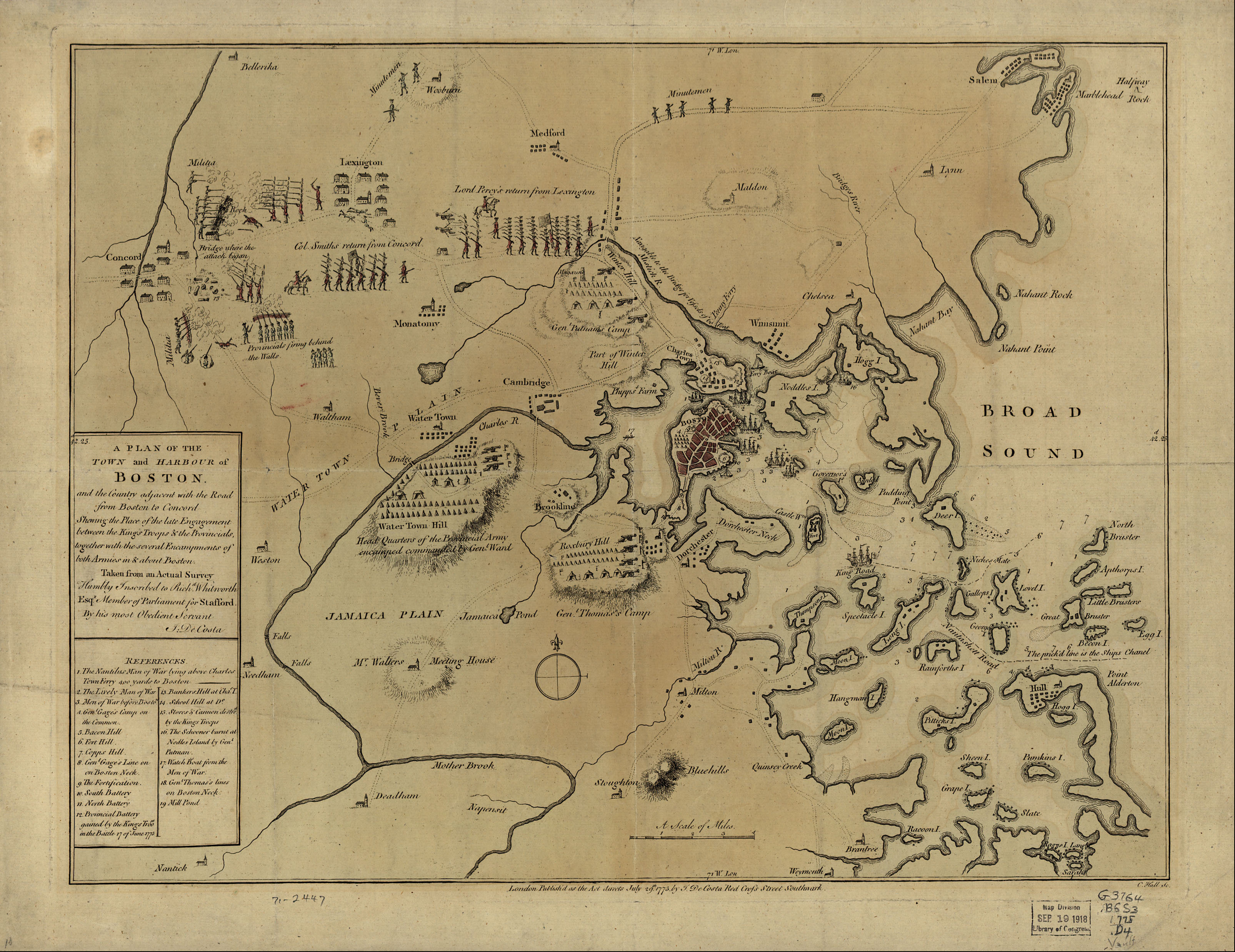
English: A mostly accurate hand-colored map depicting the 1775 Battles of Lexington and Concord and the Siege of Boston |
| تاریخ | |
| قایناق |
From the Library of Congress American Memory. |
| یازار | J. DeCosta |
| آیری نوسخهلر |
 |
Large text box
TOWN and HARBOUR of
Boston.
and the Country adjacent with the Road
from Boston to Concord
Shewing the Place of the late Engagement
between the King's Troops & the Provincials,
together with the several Encampments of
both Armies in & about Boston.
Taken from an Actual Survey
Humbly Inscribed to Rich d. Whitworth
Esqr. Member of Parliament for Stafford
Legend
References.
- The Nautilus Man of War lying above Charles
- Town Ferry 400 yards to Boston
- The Lively Man of War
- Men of War before Boston.
- Gen l. Gage's Camp on
- the Common.
- Bacon Hill [i.e. Beacon Hill]
- Fort Hill.
- Copps Hill.
- Gen l. Gage's Line on
- on Boston Neck.
- The Fortification.
- South Battery
- North Battery
- Provincial Battery
- gained by the King's Troo ps
- in the Battle 17 of June 1775
- Bunkers Hill at Cha s. T.
- School Hill at D o.
- Stores & Cannon destro d
- by the King's Troops
- The Schooner burnt at
- Nodles Island by Gen l.
- Putman
- Watch Boat from the Men of War.
- Gen l. Thomas's lines
- on Boston Neck
- Mill Pond
Text along the bottom
- London Publish'd as the Act directs July 29th. 1775 by J. De Costa Red Croſs Street Southwark.

|
این نگاره از کتابخانهٔ کنگره ایالات متحده بحش جغراقیا و نقشه تحت شناسهٔ دیجیتالی g3764b.ar090000 موجود است.
این برچست وضعیت حق تکثیر اثر ضمیمه شده را مشخص نمیکند. یک برچسپ معمولی همچنان مورد نیاز است. Commons:Licensing را برای کسب اطلاعات مشاهده فرمایید.
|
|
این اثر در کشورهایی و مناطقی که مدت زمان حق تکثیر، عمر پدیدآورنده بعلاوه 100 سال یا کمتر بعد از مرگ او است، در مالکیت عمومی قرار دارد. | |
| این پرونده تحت قانون حق تکثیر محدودیت آزاد منتشر شده که شامل تمامی حقوق مربوطه و حقوق نزدیک به آن میشود. | |
فايل گئچمیشی
فايلین اولکی وئرسیياسینی گؤرمک اۆچون گۆن/تاریخ بؤلمهسیندهکی تاریخلری تێقلايین.
| تاریخ/واخت | کیچیک عکس | اؤلچولر | ایشلدن | باخیش | |
|---|---|---|---|---|---|
| ایندیکی | ۱۰ مئی ۲۰۰۵، ساعت ۰۷:۳۰ | | ۳٬۲۱۱ در ۲٬۴۷۶ (۱٫۵۵ مگابایت) | Flying Jazz | "A plan of the town and harbour of Boston and the country adjacent with the road from Boston to Concord, shewing the place of the late engagement between the King's troops & the provincials, together with the several encampments of both armies in & about |
فايل ایشلدمهسی
آشاغیداکی صحیفه بو فایلا باغلانیر
فایلین باشاباش ایشلنیلمهسی
بو فایل آشاغی داکی آیری ویکی لرده ایشلَنیر:
- az.wikipedia.org-ده ایشلنمهسی
- ca.wikipedia.org-ده ایشلنمهسی
- cs.wikipedia.org-ده ایشلنمهسی
- da.wikipedia.org-ده ایشلنمهسی
- de.wikipedia.org-ده ایشلنمهسی
- en.wikipedia.org-ده ایشلنمهسی
- en.wikivoyage.org-ده ایشلنمهسی
- es.wikipedia.org-ده ایشلنمهسی
- fi.wikipedia.org-ده ایشلنمهسی
- fo.wikipedia.org-ده ایشلنمهسی
- fr.wikipedia.org-ده ایشلنمهسی
- fr.wikiversity.org-ده ایشلنمهسی
- it.wikipedia.org-ده ایشلنمهسی
- it.wikivoyage.org-ده ایشلنمهسی
- ja.wikipedia.org-ده ایشلنمهسی
- no.wikipedia.org-ده ایشلنمهسی
- pl.wikipedia.org-ده ایشلنمهسی
- ro.wikipedia.org-ده ایشلنمهسی
- sr.wikipedia.org-ده ایشلنمهسی
- th.wikipedia.org-ده ایشلنمهسی
- www.wikidata.org-ده ایشلنمهسی
- zh.wikipedia.org-ده ایشلنمهسی