
فایل:Lizars Mexico & Guatimala 1836 UTA (detail of Texas).jpg
سیناق گؤستریشی اؤلچوسو: ۶۹۴ × ۶۰۰ پیکسل. آیری کیفیتلر: ۲۷۸ × ۲۴۰ پیکسل | ۵۵۵ × ۴۸۰ پیکسل | ۸۸۹ × ۷۶۸ پیکسل | ۱٬۱۸۵ × ۱٬۰۲۴ پیکسل | ۱٬۳۵۷ × ۱٬۱۷۳ پیکسل.
فایلین اصلی (۱٬۳۵۷ × ۱٬۱۷۳ پیکسل, فایل اؤلچوسو: ۹۸۳ کیلوبایت, MIME نوعو: image/jpeg)
قیساسی
| عنوان مقاله |
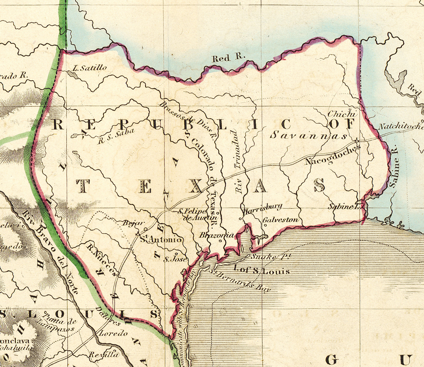
English: Mexico & Guatimala [sic] |
||||||||||||||||||||||||||
| Description |
English: Shortly after Texas declared its independence from Mexico in 1836, the Edinburgh painter, engraver, printer, cartographer, lithographer, and publisher William Home Lizars (1788-1859), brother of Daniel Lizars II (1793-1875), updated the original plate for the map of Mexico & Guatemala to include the new republic. He added the towns of Galveston, Harrisburg, Brazoria, S. Felipe de Austin (although recently destroyed), Bejar, and "S. Jose" (probably intended to represent Goliad). Lizars made no further improvements to the general cartographic shape of the republic except to show the Nueces River as the southern boundary and the western boundary curving to the point where the 100th meridian strikes the Red River. The map continues to show Mexico's administrative districts as Spanish Intendencies (Intendencias) and Internal Provinces (Provincias Internas) over fifteen years since Mexico's independence. |
||||||||||||||||||||||||||
| تاریخ | حوالی ۱۸۳۶ | ||||||||||||||||||||||||||
| قایناق | UTA Libraries Cartographic Connections: نقشه / text | ||||||||||||||||||||||||||
| پدیدآورنده |
|
||||||||||||||||||||||||||
| اعتبار خطی |
English: The University of Texas at Arlington Libraries Special Collections, Gift of Lewis & Virginia Buttery |
||||||||||||||||||||||||||
| Geotemporal data | |||||||||||||||||||||||||||
| Map location | تگزاس ایالتی | ||||||||||||||||||||||||||
| Georeferencing | If inappropriate please set warp_status = skip to hide. | ||||||||||||||||||||||||||
| Bibliographic data | |||||||||||||||||||||||||||
| نشر (یایلما)یئری | ادینبورق | ||||||||||||||||||||||||||
| یایمچی |
|
||||||||||||||||||||||||||
| Archival data | |||||||||||||||||||||||||||
| مجموعه |
|
||||||||||||||||||||||||||
| اؤلچولر | بلندی: ۴۲٫۰ سانتیمتر؛ عرض: ۵۱٫۵ سانتیمتر | ||||||||||||||||||||||||||
| اورتا | colored engraving on paper | ||||||||||||||||||||||||||
| artwork-references |
Worms, Laurence; Ashley Baynton-Williams (۲۰۱۱) British Map Engravers، لندن: Rare Book Society، صص. 406–409 |
||||||||||||||||||||||||||
| آیری نوسخهلر | |||||||||||||||||||||||||||

.jpg)
لیسانس

|
This file was provided to Wikimedia Commons by the University of Texas at Arlington Libraries as part of a cooperation project. The University of Texas at Arlington Libraries is part of the University of Texas at Arlington, a public research university located in Arlington, Texas.
|
|
پدیدآورنده این اثر در سال 1859 درگذشته است، پس این اثر در کشورهایی و مناطقی که مدت زمان حق تکثیر، عمر پدیدآورنده بعلاوه 100 سال یا کمتر بعد از مرگ او است، در مالکیت عمومی قرار دارد. این اثر در ایالات متحده آمریکا در مالکیت عمومی قرار دارد به این دلیل که قبل از ۱ ژانویهٔ ۱۹۲۹ منتشر یا در ادارهٔ حق تکثیر آمریکا ثبت شدهاست. | |
| این پرونده تحت قانون حق تکثیر محدودیت آزاد منتشر شده که شامل تمامی حقوق مربوطه و حقوق نزدیک به آن میشود. | |
فايل گئچمیشی
فايلین اولکی وئرسیياسینی گؤرمک اۆچون گۆن/تاریخ بؤلمهسیندهکی تاریخلری تێقلايین.
| تاریخ/واخت | کیچیک عکس | اؤلچولر | ایشلدن | باخیش | |
|---|---|---|---|---|---|
| ایندیکی | ۱۳ جولای ۲۰۱۹، ساعت ۱۵:۱۸ | | ۱٬۳۵۷ در ۱٬۱۷۳ (۹۸۳ کیلوبایت) | Michael Barera | File:Lizars Mexico & Guatimala 1836 UTA.jpg cropped 79 % horizontally, 78 % vertically using CropTool with precise mode. |
فايل ایشلدمهسی
آشاغیداکی صحیفه بو فایلا باغلانیر
فایلین باشاباش ایشلنیلمهسی
بو فایل آشاغی داکی آیری ویکی لرده ایشلَنیر:
- ca.wikipedia.org-ده ایشلنمهسی
- cv.wikipedia.org-ده ایشلنمهسی
- en.wikipedia.org-ده ایشلنمهسی
- eo.wikipedia.org-ده ایشلنمهسی
- fa.wikipedia.org-ده ایشلنمهسی
- it.wikipedia.org-ده ایشلنمهسی
- ja.wikipedia.org-ده ایشلنمهسی
- ko.wikipedia.org-ده ایشلنمهسی
- mk.wikipedia.org-ده ایشلنمهسی
- mzn.wikipedia.org-ده ایشلنمهسی
- pl.wikipedia.org-ده ایشلنمهسی
- pt.wikipedia.org-ده ایشلنمهسی
- sv.wikipedia.org-ده ایشلنمهسی
- th.wikipedia.org-ده ایشلنمهسی
- yi.wikipedia.org-ده ایشلنمهسی
- zh-min-nan.wikipedia.org-ده ایشلنمهسی
.jpg)