
فایل:Manchester Free Trade Hall (Radisson Edwardian Hotel).jpg
فایلین اصلی (۶۴۰ × ۶۴۰ پیکسل, فایل اؤلچوسو: ۶۰۴ کیلوبایت, MIME نوعو: image/jpeg)
.jpg)
قیساسی
| آچیقلاما |
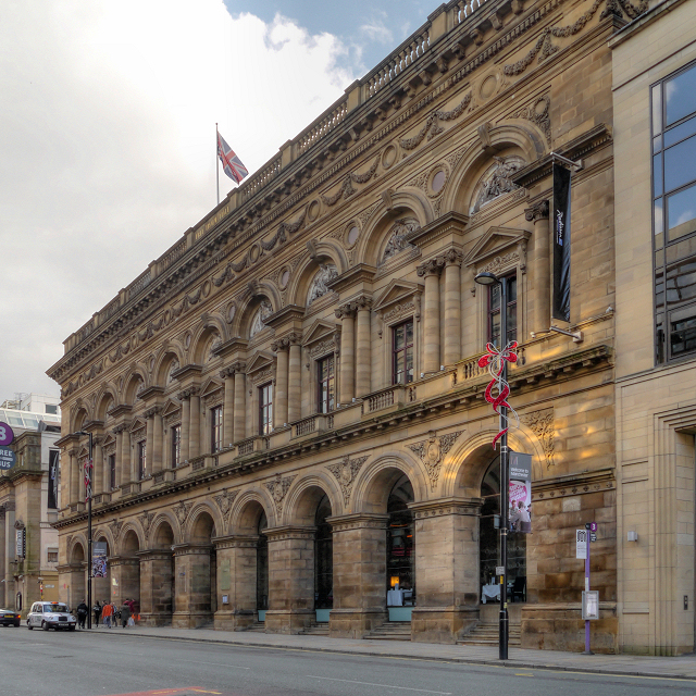
English: The Peter Street frontage of the Radisson Edwardian Hotel, originally built as the Free Trade Hall.
The Free Trade Hall was a public hall constructed in 1853–6 to commemorate the repeal of the Corn Laws in 1846. The hall was funded by public subscription and became a concert hall and home of the Hallé Orchestra in 1858. The interior of the hall had to be rebuilt after bombing during the Manchester Blitz left it an empty shell; it re-opened in 1951. As well as housing the Hallé Orchestra, it was used for pop and rock concerts; it was Manchester's premier concert venue until the construction of the Bridgewater Hall in 1996. When the Hallé Orchestra moved to the Bridgewater Hall in 1996, the Free Trade Hall was closed by Manchester City Council. In 1997, the building was sold to private developers and, despite much opposition because of its historical significance, planning approval was eventually granted to convert it to a hotel, retaining the original facade was, the main staircase and the 1950s statues that were formerly attached to its rear wall. The hotel opened in 2004. The hall is designated as a Grade II* listed building. A red plaque on the wall records that it was built on St Peter's Fields, the site of the (in)famous Peterloo Massacre in 1819. |
| تاریخ | |
| قایناق | https://www.geograph.org.uk/photo/3178858 |
| یازار | David Dixon |
| موجَویز (required by the license) | David Dixon / Manchester Free Trade Hall (Radisson Edwardian Hotel) / |
| مختصات دوربین | | محل قرارگیری این نگاره و سایر نگارهها در: نقشهٔ شهری باز |
|---|
.jpg¶ms=053.478060_N_-002.247600_E_globe:Earth_type:camera_source:geograph-osgb36(SJ83669795)_heading:112.00&language=azb)
| مختصات شیء | | محل قرارگیری این نگاره و سایر نگارهها در: نقشهٔ شهری باز |
|---|
.jpg¶ms=053.477880_N_-002.247100_E_globe:Earth_class:object_type:object_source:geograph-osgb36(SJ83699793)_heading:112.00&language=azb)
لیسانس

|
این نگاره از مجموعهٔ پروژهٔ Geograph گرفته شدهاست. این صفحهٔ عکسها را در وبگاه Geograph برای جزئیات تماس با عکاس ببینید. حق تکثیر این تصویر به David Dixon تعلق دارد و برای استفادهٔ مجدد تحت Creative Commons Attribution-ShareAlike 2.0 مجوزدهی شدهاست.
|
- سیزین ایجازه نیز وار دیر:
- بؤلۆشمک – اثرین کپی، پایلاشماق و چاتدیرماسی اوچون
- تلفیق ائت – اثرین توتوشدورماسی اوچون
- آشاغی داکی شرایطله:
- تخصیص – اثری مؤلف و یا لیسئنزییالی طرفیندن گؤستریلدیی کیمی ایستیناد ائتملیسینیز (آنجاق سنی دستکلدیینی و یا اثردن ایستیفاده ائتمیینیزی تکلیف ائتمملیسینیز).
- بیرگه پایلاشیم – اگر بو اثرده دَییشدیرمه، چؤندرمه، یا دا کؤکدن دوزلتمه ائتسز، اله گلمیش اثری یالنیز بیر ائشیت یوخسا اوخشار بیر مجوزین آلتیندا یاییملایابیلرسینیز .
فايل گئچمیشی
فايلین اولکی وئرسیياسینی گؤرمک اۆچون گۆن/تاریخ بؤلمهسیندهکی تاریخلری تێقلايین.
| تاریخ/واخت | کیچیک عکس | اؤلچولر | ایشلدن | باخیش | |
|---|---|---|---|---|---|
| ایندیکی | ۲۱ ژانویه ۲۰۱۴، ساعت ۱۱:۲۲ | | ۶۴۰ در ۶۴۰ (۶۰۴ کیلوبایت) | Ham II | User created page with UploadWizard |
فايل ایشلدمهسی
آشاغیداکی صحیفه بو فایلا باغلانیر
فایلین باشاباش ایشلنیلمهسی
بو فایل آشاغی داکی آیری ویکی لرده ایشلَنیر:
- az.wikipedia.org-ده ایشلنمهسی
- en.wikipedia.org-ده ایشلنمهسی
- he.wikipedia.org-ده ایشلنمهسی
- ru.wikipedia.org-ده ایشلنمهسی
- zh.wikipedia.org-ده ایشلنمهسی
.jpg)