
فایل:Map of Kentucky highlighting Mason County.svg

حجم پیشنمایش PNG این SVG file:۸۰۰ × ۳۴۵ پیکسل آیری کیفیتلر: ۳۲۰ × ۱۳۸ پیکسل | ۶۴۰ × ۲۷۶ پیکسل | ۱٬۰۲۴ × ۴۴۱ پیکسل | ۱٬۲۸۰ × ۵۵۱ پیکسل | ۲٬۵۶۰ × ۱٬۱۰۳ پیکسل | ۶٬۷۷۰ × ۲٬۹۱۶ پیکسل.
فایلین اصلی (SVG فایلی، ۶٬۷۷۰ × ۲٬۹۱۶ پیکسئل، فایلین اؤلچوسو: ۱۲۷ کیلوبایت)
قیساسی
| آچیقلاما |
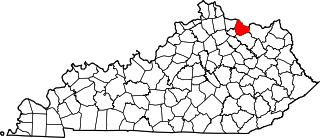
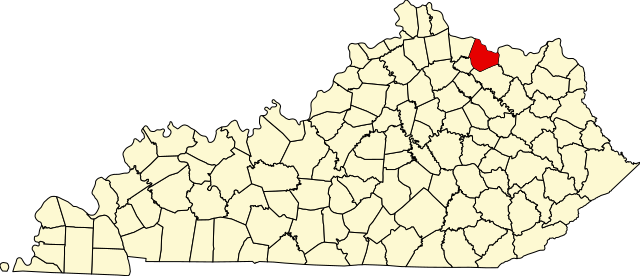
English: This is a locator map showing Mason County in Kentucky. For more information, see Commons:United States county locator maps. |
| تاریخ | |
| قایناق |
یوکلهیهنین اؤز ایشی: English: The maps use data from nationalatlas.gov, specifically countyp020.tar.gz on the Raw Data Download page. The maps also use state outline data from statesp020.tar.gz. The Florida maps use hydrogm020.tar.gz to display Lake Okeechobee. |
| یازار | David Benbennick |
لیسانس
| من، دارنده حق تکثیر این اثر، این اثر را به مالکیت عمومی منتشر میکنم. این قابل اجرا در تمام نقاط جهان است. در برخی از کشورها ممکن است به صورت قانونی این امکانپذیر نباشد؛ اگر چنین است: من اجازهٔ استفاده از این اثر را برای هر مقصودی، بدون هیچگونه شرایطی میدهم، تا وقتی که این شرایط توسط قانون مستلزم نشده باشد. |
فايل گئچمیشی
فايلین اولکی وئرسیياسینی گؤرمک اۆچون گۆن/تاریخ بؤلمهسیندهکی تاریخلری تێقلايین.
| تاریخ/واخت | کیچیک عکس | اؤلچولر | ایشلدن | باخیش | |
|---|---|---|---|---|---|
| ایندیکی | ۱۲ فوریه ۲۰۰۶، ساعت ۱۲:۲۳ | | ۶٬۷۷۰ در ۲٬۹۱۶ (۱۲۷ کیلوبایت) | David Benbennick | {{subst:User:Dbenbenn/clm|county=Mason County|state=Kentucky}} |
فايل ایشلدمهسی
آشاغیداکی صحیفه بو فایلا باغلانیر
فایلین باشاباش ایشلنیلمهسی
بو فایل آشاغی داکی آیری ویکی لرده ایشلَنیر:
- ar.wikipedia.org-ده ایشلنمهسی
- bg.wikipedia.org-ده ایشلنمهسی
- bpy.wikipedia.org-ده ایشلنمهسی
- cdo.wikipedia.org-ده ایشلنمهسی
- ceb.wikipedia.org-ده ایشلنمهسی
- ce.wikipedia.org-ده ایشلنمهسی
- ckb.wikipedia.org-ده ایشلنمهسی
- cs.wikipedia.org-ده ایشلنمهسی
- cy.wikipedia.org-ده ایشلنمهسی
- de.wikipedia.org-ده ایشلنمهسی
- en.wikipedia.org-ده ایشلنمهسی
- Mason County, Kentucky
- Dover, Kentucky
- Maysville, Kentucky
- Sardis, Kentucky
- Germantown, Kentucky
- List of counties in Kentucky
- Template:Mason County, Kentucky
- User:Nyttend/County templates/KY/2
- Shannon, Kentucky
- National Register of Historic Places listings in Mason County, Kentucky
- Fox Farm site (Mays Lick, Kentucky)
- Mays Lick, Kentucky
- Category:Populated places in Mason County, Kentucky
- Template:MasonCountyKY-geo-stub
- Minerva, Kentucky
- Orangeburg, Kentucky
- Fernleaf, Kentucky
- Helena, Kentucky
- Weedonia, Kentucky
- Somo, Kentucky
- Lawrence Creek (Kentucky)
- es.wikipedia.org-ده ایشلنمهسی
- et.wikipedia.org-ده ایشلنمهسی
- eu.wikipedia.org-ده ایشلنمهسی
- fa.wikipedia.org-ده ایشلنمهسی
- fa.wikivoyage.org-ده ایشلنمهسی
- frr.wikipedia.org-ده ایشلنمهسی
- fr.wikipedia.org-ده ایشلنمهسی
بو فایلینسراسری ایستفاده لرینه باخین.