فایل:Nile River and delta from orbit.jpg

Page contents not supported in other languages.
ویکی‌پدیادان، آچیق بیلیک‌لیک‌دن

Nile_River_and_delta_from_orbit.jpg(۷۰۰ × ۵۵۰ پیکسل, فایل اؤلچوسو: ۸۵ کیلوبایت, MIME نوعو: image/jpeg)

بو فایل ویکی‌انبار-دن‌دیر و آیری پروژه‌ده ایستیفاده اولماق امکانی وار. اونون باره‌سینده اولان شرح فایلین شرح صحیفه‌سی آشاغیدا گوستریلیب.

قیساسی

آچیقلاما

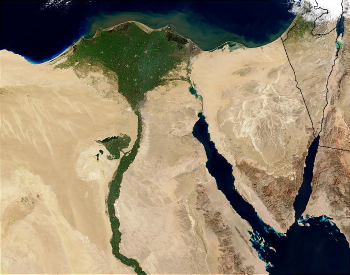
Nile River and delta from orbit Description: The Nile River and delta as seen from space by the MODIS sensor on the Terra satellite.

"Against the barren desert of northeastern Africa, the fertile valley of the Nile River runs northward through Egypt. In the higher-resolution images, the city of Cairo can be seen as a gray smudge right where the river widens into its broad fan-shaped delta. Other cities are dotted across the green landscape, giving it a speckled appearance. Where the Nile empties into the Mediterranean Sea (top) the waters are swirling with color, likely a mixture of sediment, organic matter, and possibly marine plant life. Farther west, the bright blue color of the water is likely less-organically rich sediment, perhaps sand.
"East of the delta lies the arid Sinai Peninsula, whose pointed tip is home to rugged mountains, some as high as 8,600 feet. The lattice work of pale lines marks the paths of ephemeral rivers. The Sinai Peninsula intrudes into the Red Sea. Farther east are Israel, Jordan, and Saudi Arabia. At top right is the disputed territory of the West Bank.
"In the false-color image, vegetation is bright green, water is dark blue or black, and clouds are light blue. It's interesting to notice that places that seem essentially arid, or desert-like in the true-color image in fact have a delicate layer of vegetation. For example, the central Sinai Peninsula, and most of Israel have a faint greenish tinge in the false-color images.
تاریخ
قایناق http://visibleearth.nasa.gov/view_rec.php?id=4927 [1]
یازار Jacques Descloitres, MODIS Rapid Response Team, NASA/sh
آیری نوسخه‌لر Cuaggjacgacugvajgca

Salchicha

لیسانس

Public domain این پرونده در مالکیت عمومی قرار دارد چرا که توسط ناسا ایجاد شده است. سیاست حق تکثیر ناسا بیان می‌کند که «مواد ناسا با حق تکثیر محافظت نمی‌شوند، مگراینکه ذکر شده باشد». (Template:PD-USGov، صفحهٔ سیاست حق تکثیر ناسا یا سیاست جی‌پی‌ال استفاده از تصاویر را ببینید.)
هشدارها:

عنوان

شرحی یک‌خطی از محتوای این فایل اضافه کنید
Nile delta

آیتم‌هایی که در این پرونده نمایش داده شده‌اند

توصیف‌ها فارسی

۵ فوریه 2003

فايل گئچمیشی

فايلین اول‌کی وئرسیياسینی گؤرمک اۆچون گۆن/تاریخ بؤلمه‌سینده‌کی تاریخلری تێقلايین.

تاریخ/واختکیچیک عکساؤلچولرایشلدنباخیش
ایندیکی‏۲۹ نوْوامبر ۲۰۰۴، ساعت ۲۲:۴۷‏۲۹ نوْوامبر ۲۰۰۴، ساعت ۲۲:۴۷ تاریخینده‌کی سۆروموندن کیچیک گؤرونتوسو۷۰۰ در ۵۵۰ (۸۵ کیلوبایت)MschlindweinNile River and delta from orbit

آشاغیداکی صحیفه بو فایلا باغلانیر

فایلین باشاباش ایشلنیلمه‌سی

بو فایل آشاغی داکی آیری ویکی لرده ایشلَنیر:

بو فایلینسراسری ایستفاده لرینه باخین.