
فایل:Oahu, Hawai'i - NASA Earth Observatory.jpg
Oahu,_Hawai'i_-_NASA_Earth_Observatory.jpg (۷۲۰ × ۴۸۰ پیکسل, فایل اؤلچوسو: ۱۳۲ کیلوبایت, MIME نوعو: image/jpeg)
قیساسی
| آچیقلاما |
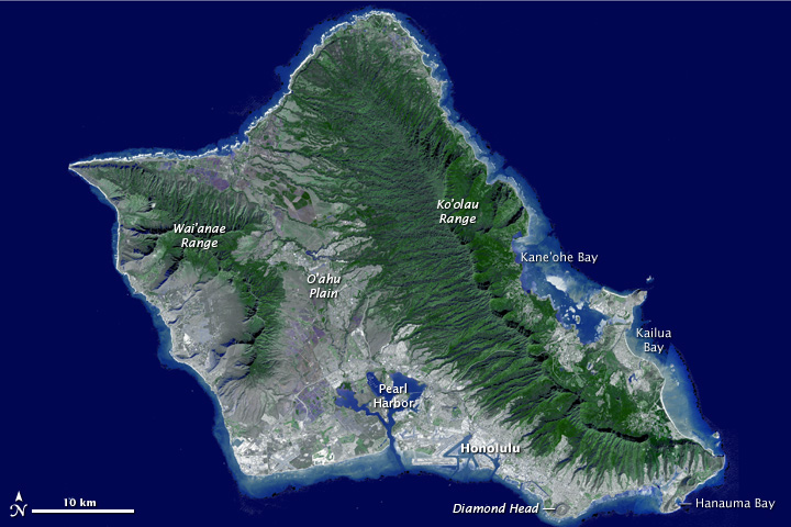
To download the full high res or the video go to: earthobservatory.nasa.gov/IOTD/view.php?id=76244&src=... Need a vacation? Paradise is as close as a mouse click away, thanks to a new fly-around tour of the island of Oahu, Hawaii. The trip comes courtesy of the Advanced Spaceborne Thermal Emission and Reflection Radiometer (ASTER) instrument on NASA’s Terra spacecraft. Sometimes called “The Gathering Place,” Oahu is the third largest of the Hawaiian Islands and home to the state’s capital city, Honolulu. The island has nearly a million residents—about 75 percent of the state’s population.Erosion and volcanism give the island its unique shape. Oahu was created from two separate shield volcanoes—Wai’anae and Ko’olau—that are connected by a central valley, the O’ahu Plain. Your virtual tour begins over Honolulu, then moves northwest over the O'ahu Plain, looking towards the northeast and the Ko’olau mountains. The valley was once largely agricultural, producing pineapple and sugar cane. Reaching the north shore, site of world-famous surfing locations like the Bonzai Pipeline, we turn to the southeast and view the Windward and East Sides of Oahu. Here you’ll find Kane’ohe and Kailua Bays and numerous small offshore islands. Reaching the southeast tip of Oahu, we fly over Hanauma Bay, a protected snorkeling and diving location, and continue past Diamond Head crater, Waikiki Beach and Honolulu. The trip ends with a flyover of Pearl Harbor, home to the largest U.S. Navy fleet in the Pacific. This flyover was created by draping ASTER image data—acquired January 13, 2010—over the new ASTER Version 2 digital elevation data. ASTER carries two telescopes used to record light reflected by the Earth. The telescopes, says ASTER science team leader Mike Abrams, are like two human eyes—seeing the world from two different angles, but combining for a three-dimensional view. Scientists used the differences between the two records to determine the ground elevation. Image courtesy NASA/GSFC/METI/ERSDAC/JAROS, and U.S./Japan ASTER Science Team. Caption adapted from the NASA Photojournal. The Earth Observatory's mission is to share with the public the images, stories, and discoveries about climate and the environment that emerge from NASA research, including its satellite missions, in-the-field research, and climate models. Like us on Facebook Follow us on Twitter |
| تاریخ | |
| قایناق | Oahu, Hawai'i |
| یازار | NASA's Earth Observatory |
| مختصات دوربین | | محل قرارگیری این نگاره و سایر نگارهها در: نقشهٔ شهری باز |
|---|
لیسانس
- سیزین ایجازه نیز وار دیر:
- بؤلۆشمک – اثرین کپی، پایلاشماق و چاتدیرماسی اوچون
- تلفیق ائت – اثرین توتوشدورماسی اوچون
- آشاغی داکی شرایطله:
- تخصیص – اثری مؤلف و یا لیسئنزییالی طرفیندن گؤستریلدیی کیمی ایستیناد ائتملیسینیز (آنجاق سنی دستکلدیینی و یا اثردن ایستیفاده ائتمیینیزی تکلیف ائتمملیسینیز).
| این نگاره در ابتدا توسط NASA Earth Observatory در https://www.flickr.com/photos/68824346@N02/6294469627 به فلیکر ارسال شدهاست و در ۲ جولای ۲۰۱۲ توسط ربات FlickreviewR بازبینیشده و اینکه نگاره تحت مجوز cc-by-2.0 منتشر شدهاست تأیید شد. |
فايل گئچمیشی
فايلین اولکی وئرسیياسینی گؤرمک اۆچون گۆن/تاریخ بؤلمهسیندهکی تاریخلری تێقلايین.
| تاریخ/واخت | کیچیک عکس | اؤلچولر | ایشلدن | باخیش | |
|---|---|---|---|---|---|
| ایندیکی | ۲ جولای ۲۰۱۲، ساعت ۱۷:۲۱ | | ۷۲۰ در ۴۸۰ (۱۳۲ کیلوبایت) | Dzlinker | == {{int:filedesc}} == {{Information |Description=To download the full high res or the video go to: [http://earthobservatory.nasa.gov/IOTD/view.php?id=76244&src=flickr earthobservatory.nasa.gov/IOTD/view.php?id=76244&src=...] Need a vacation? Paradise... |
فايل ایشلدمهسی
آشاغیداکی صحیفه بو فایلا باغلانیر
فایلین باشاباش ایشلنیلمهسی
بو فایل آشاغی داکی آیری ویکی لرده ایشلَنیر:
- ja.wikipedia.org-ده ایشلنمهسی