
فایل:OttomanEmpireIn1683 ar.png
سیناق گؤستریشی اؤلچوسو: ۶۳۷ × ۵۹۹ پیکسل. آیری کیفیتلر: ۲۵۵ × ۲۴۰ پیکسل | ۵۱۰ × ۴۸۰ پیکسل | ۸۱۶ × ۷۶۸ پیکسل | ۱٬۰۸۸ × ۱٬۰۲۴ پیکسل | ۱٬۹۶۶ × ۱٬۸۵۰ پیکسل.
فایلین اصلی (۱٬۹۶۶ × ۱٬۸۵۰ پیکسل, فایل اؤلچوسو: ۳۷۹ کیلوبایت, MIME نوعو: image/png)

|
این map نگاره میبایست با استفاده از گرافیک برداری اسویجی فایل بازسازی شوند. این چند مزیت دارد؛ Commons:Media for cleanup را برای اطلاعات بیشتر ببینید. اگر حالت برداری آن در حال حاضر موجود است، لطفاً آن را بار کنید. پس از بارکردن یک اسویجی، این الگو را با {{vector version available|new image name.svg}} جایگزین کنید.
|
| آچیقلاما |
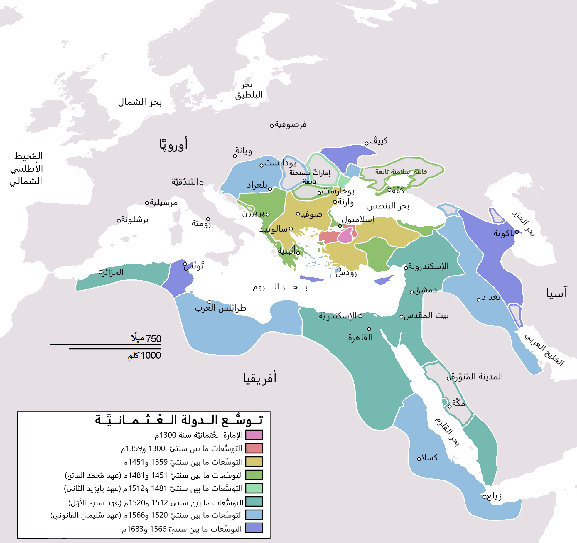
English: Map depicting the Ottoman Empire at its greatest extent, in 1683. Türkçe: Osmanlı İmparatorluğu en geniş sınırları (1683) |
| تاریخ | (UTC) |
| قایناق | |
| یازار |
|
| آیری نوسخهلر |
[]
|


| این یک عکس دستکاری شده است به این معنی که به صورت دیجیتالی از نسخهٔ اصلی تغییر یافتهاست. تغییرها: translated to arabic. اصل آن را میتوان در اینجا مشاهده کرد: OttomanEmpireIn1683.png. تغییرها توسط Bassem انجام شدهاست.
|
من، صاحب حقوق قانونی این اثر، به این وسیله این اثر را تحث اجازهنامهٔ ذیل منتشر میکنم:
| من، دارنده حق تکثیر این اثر، این اثر را به مالکیت عمومی منتشر میکنم. این قابل اجرا در تمام نقاط جهان است. در برخی از کشورها ممکن است به صورت قانونی این امکانپذیر نباشد؛ اگر چنین است: من اجازهٔ استفاده از این اثر را برای هر مقصودی، بدون هیچگونه شرایطی میدهم، تا وقتی که این شرایط توسط قانون مستلزم نشده باشد. |
اورجینال یوکلمه گوندهلیگی
This image is a derivative work of the following images:
- File:OttomanEmpireIn1683.png licensed with PD-self
- 2010-12-10T23:11:12Z Lambiam 1966x1850 (347599 Bytes) Scale indicator more up to actual scale
- 2010-11-16T18:53:38Z Hamelin de Guettelet 1966x1850 (375469 Bytes) {{Information |Description= Rhodes et autres îles ne sont prises aux Hospitaliers que le 1 janvier 1523 |Source={{own}} |Date=16 novembre 2010 |Author=[[User:Hamelin de Guettelet|Hamelin de Guettelet]] |Permission= |other_ve
- 2010-04-01T10:40:16Z Nedim Ardoğa 1966x1850 (334406 Bytes) Reverted to version as of 07:37, 10 March 2010
- 2010-03-31T12:11:05Z Bahramm 2 637x599 (168664 Bytes) Reverted to version as of 14:12, 1 March 2010
- 2010-03-10T07:37:04Z Nedim Ardoğa 1966x1850 (334406 Bytes) Reverted to version as of 20:35, 21 February 2010
- 2010-03-01T14:12:01Z Bahramm 2 637x599 (168664 Bytes) Reverted to version as of 18:51, 24 January 2010
- 2010-02-21T20:35:06Z Nedim Ardoğa 1966x1850 (334406 Bytes) Reverted to version as of 15:12, 26 March 2007
- 2010-01-24T18:51:26Z Persia2099 637x599 (168664 Bytes) Minor Update
- 2007-03-26T15:12:25Z AtilimGunesBaydin 1966x1850 (334406 Bytes) Updated Ionian Islands.
- 2007-03-15T01:25:07Z Stevanb 1966x1850 (310597 Bytes) Corrected some error. Very important (historical) Ottoman "city" in Balkan area is Prizren - on the map marked as Kosovo. Kosovo is region, Prizren is town (Ottoman "city").
- 2007-02-25T16:28:59Z AtilimGunesBaydin 1966x1850 (334954 Bytes) Minor update.
- 2007-02-18T02:34:25Z AtilimGunesBaydin 1966x1850 (335164 Bytes) Update territories, some city locations and labels.
- 2007-02-14T23:50:38Z AtilimGunesBaydin 1940x1500 (313464 Bytes) Minor fixes, updated some borders and the color scheme.
- 2006-12-23T00:55:59Z AtilimGunesBaydin 1684x1348 (289614 Bytes) Added more labels.
- 2006-12-21T17:47:33Z AtilimGunesBaydin 1684x1347 (249515 Bytes) {{Information |Description=Map depicting the [[:en:Ottoman Empire|Ottoman Empire]] at its greatest extent, in 1683. |Source=Self drawn, based on information mainly compiled from [[:Image:Ottoman 1683.png]], [http://fs.hunting
Uploaded with derivativeFX
فايل گئچمیشی
فايلین اولکی وئرسیياسینی گؤرمک اۆچون گۆن/تاریخ بؤلمهسیندهکی تاریخلری تێقلايین.
| تاریخ/واخت | کیچیک عکس | اؤلچولر | ایشلدن | باخیش | |
|---|---|---|---|---|---|
| ایندیکی | ۴ نوْوامبر ۲۰۲۱، ساعت ۱۹:۰۶ | | ۱٬۹۶۶ در ۱٬۸۵۰ (۳۷۹ کیلوبایت) | باسم | Fixed Several mistakes - تصويب أخطاءٌ عدَّة |
| ۱۷ جولای ۲۰۱۵، ساعت ۱۹:۵۴ |  | ۱٬۹۶۶ در ۱٬۸۵۰ (۴۳۱ کیلوبایت) | باسم | Better Version - نسخة أفضل | |
| ۱ ژانویه ۲۰۱۱، ساعت ۱۹:۵۸ |  | ۶۳۷ در ۵۹۹ (۱۰۵ کیلوبایت) | باسم | {{Information |Description={{en|Map depicting the Ottoman Empire at its greatest extent, in 1683.}} {{tr|Osmanlı İmparatorluğu en geniş sınırları (1683)}} |Source=*[[:File:OttomanEmpireIn1683. |
فايل ایشلدمهسی
آشاغیداکی صحیفه بو فایلا باغلانیر
فایلین باشاباش ایشلنیلمهسی
بو فایل آشاغی داکی آیری ویکی لرده ایشلَنیر:
- ar.wikipedia.org-ده ایشلنمهسی
- الدولة العثمانية
- تركيا
- سليمان القانوني
- أهل السنة والجماعة
- غامد
- تاريخ ليبيا
- أتراك
- ترك
- عثمانية جديدة
- قائمة سلاطين الدولة العثمانية
- مستخدم:منصورالواقدي/ملعب
- الأقليات التركية في الدولة العثمانية السابقة
- الدولة العثمانية في شبه الجزيرة العربية
- الحرب العثمانية الصفوية (1578–1590)
- الحرب العثمانية الصفوية (1603–1618)
- تاريخ الدولة العثمانية
- مرحلة ركود الدولة العثمانية
- قائمة أكبر الإمبراطوريات
- مستخدم:منصورالواقدي/مسودة
- التسلسل الزمني لتاريخ الشرق الأوسط
- شجرة العائلة العثمانية
- تاريخ منطقة البحر المتوسط
- إمبراطوريات الشرق الأوسط
- قائمة القوى العظمى الحديثة
- ولاية (هيمنة)
- مجتمعات تركية
- ar.wikiquote.org-ده ایشلنمهسی
- arz.wikipedia.org-ده ایشلنمهسی
- pnb.wikipedia.org-ده ایشلنمهسی
- ur.wikipedia.org-ده ایشلنمهسی