
فایل:Serbia-WW1-4.jpg
سیناق گؤستریشی اؤلچوسو: ۷۹۹ × ۲۷۱ پیکسل. آیری کیفیتلر: ۳۲۰ × ۱۰۹ پیکسل | ۱٬۰۲۳ × ۳۴۷ پیکسل.
فایلین اصلی (۱٬۰۲۳ × ۳۴۷ پیکسل, فایل اؤلچوسو: ۹۹ کیلوبایت, MIME نوعو: image/jpeg)

|
This map has been uploaded by Electionworld from en.wikipedia.org to enable the |
قیساسی
| آچیقلاما |
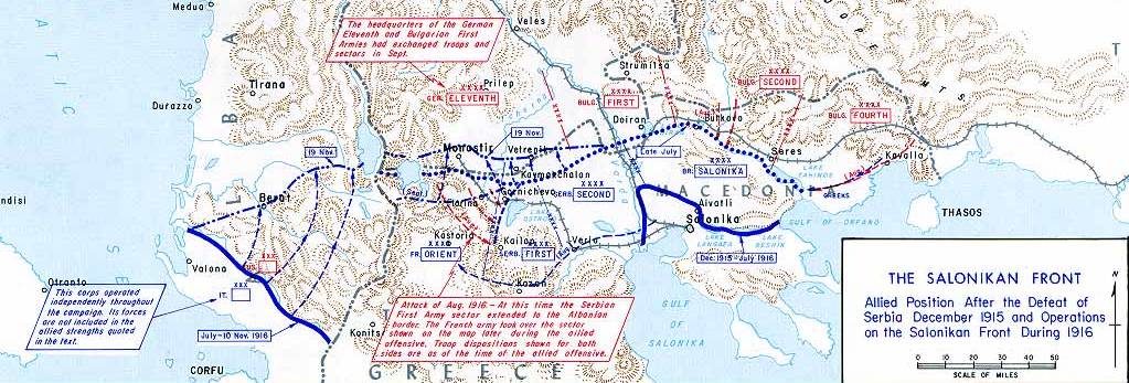
English: Operations at the border of Greece and Serbia, 1916.
his map was created by the Department of Military Art and Engineering, at the U.S. Military Academy (West Point). The initial version was created under the supervision of General Vincent Esposito in 1959. It is now available on the West Point |
||||||
| تاریخ | |||||||
| قایناق | West Point | ||||||
| یازار | General Vincent Esposito | ||||||
| ایجازه (فایلین تکرار ایستیفادهسی) |
|
||||||
| آیری نوسخهلر |
  |
||||||

فايل گئچمیشی
فايلین اولکی وئرسیياسینی گؤرمک اۆچون گۆن/تاریخ بؤلمهسیندهکی تاریخلری تێقلايین.
| تاریخ/واخت | کیچیک عکس | اؤلچولر | ایشلدن | باخیش | |
|---|---|---|---|---|---|
| ایندیکی | ۲۱ دسامبر ۲۰۰۶، ساعت ۲۱:۵۵ | ۱٬۰۲۳ در ۳۴۷ (۹۹ کیلوبایت) | Electionworld | {{ew|en|Cglassey}} == Summary == Operations at the border of Greece and Serbia, 1916. his map was created by the Department of Military Art and Engineering, at the U.S. Military Academy (West Point). The initial version was created under the supervision |
فايل ایشلدمهسی
آشاغیداکی صحیفه بو فایلا باغلانیر
فایلین باشاباش ایشلنیلمهسی
بو فایل آشاغی داکی آیری ویکی لرده ایشلَنیر:
- ar.wikipedia.org-ده ایشلنمهسی
- az.wikipedia.org-ده ایشلنمهسی
- be-tarask.wikipedia.org-ده ایشلنمهسی
- be.wikipedia.org-ده ایشلنمهسی
- bg.wikipedia.org-ده ایشلنمهسی
- bs.wikipedia.org-ده ایشلنمهسی
- ca.wikipedia.org-ده ایشلنمهسی
- de.wikipedia.org-ده ایشلنمهسی
- el.wikipedia.org-ده ایشلنمهسی
- en.wikipedia.org-ده ایشلنمهسی
- History of modern Macedonia (Greece)
- Maurice Sarrail
- Macedonian front
- Battle of Doiran (1917)
- Greece during World War I
- Monastir offensive
- Autonomous Province of Korçë
- Bulgarian occupation of Albania
- World War I in Albania
- Battle of the Crna Bend (1917)
- User:GerardM/Battles including the Ottoman Empire
- User:Falcaorib
- User:BoDr12/sandbox
- es.wikipedia.org-ده ایشلنمهسی
- fa.wikipedia.org-ده ایشلنمهسی
- fr.wikipedia.org-ده ایشلنمهسی
- he.wikipedia.org-ده ایشلنمهسی
- hr.wikipedia.org-ده ایشلنمهسی
- hu.wikipedia.org-ده ایشلنمهسی
- it.wikipedia.org-ده ایشلنمهسی
بو فایلینسراسری ایستفاده لرینه باخین.