
فایل:Taunton road map1948.jpg

سیناق گؤستریشی اؤلچوسو: ۶۶۴ × ۶۰۰ پیکسل. آیری کیفیتلر: ۲۶۶ × ۲۴۰ پیکسل | ۵۳۱ × ۴۸۰ پیکسل | ۸۵۰ × ۷۶۸ پیکسل | ۱٬۲۴۱ × ۱٬۱۲۱ پیکسل.
فایلین اصلی (۱٬۲۴۱ × ۱٬۱۲۱ پیکسل, فایل اؤلچوسو: ۷۳۵ کیلوبایت, MIME نوعو: image/jpeg)
قیساسی
| آچیقلاما |
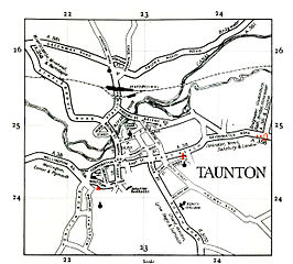
English: OS map of Taunton area, UK. |
| تاریخ | |
| قایناق | Ordnance Survey map, originally uploaded on en.wiki under same name. |
| یازار | Ordnance Survey |
لیسانس
This work is an Ordnance Survey map over 50 years old, which is covered by Crown Copyright which in this case expires 50 years after publication. Ordnance Survey does however ask that they be credited and that the date of publication be given.
Any ancillary rights gained through the creation of the electronic version are granted as freely usable under any circumstances.
|
This work created by the United Kingdom Government is in the public domain.
This is because it is one of the following:
HMSO has declared that the expiry of Crown Copyrights applies worldwide (ref: HMSO Email Reply)
|
 |
اورجینال یوکلمه گوندهلیگی
The original description page is/was here (log). All following user names refer to en.wikipedia.
- 2006-12-02 23:05 Steinsky 1241x1121 (168 KB) ((OS map from 1948 {{oldOS}})
- 2007-04-06 22:31 Steinsky 1241x1121 (735 KB) (Tidied up)

|
ردههای این نگاره میبایست بررسی شوند. آنها را الآن بررسی کنید!
|
فايل گئچمیشی
فايلین اولکی وئرسیياسینی گؤرمک اۆچون گۆن/تاریخ بؤلمهسیندهکی تاریخلری تێقلايین.
| تاریخ/واخت | کیچیک عکس | اؤلچولر | ایشلدن | باخیش | |
|---|---|---|---|---|---|
| ایندیکی | ۲۵ آقوست ۲۰۰۹، ساعت ۱۸:۳۶ | | ۱٬۲۴۱ در ۱٬۱۲۱ (۷۳۵ کیلوبایت) | Sv1xv | {{Information |Description={{en|1=OS map of Taunton area, UK.}} |Source=Ordnance Survey map, originally uploaded on en.wiki under same name. |Author=Ordnance Survey |Date=1948 |Permission= |other_versions= }} =={{int:license}}== {{OldOS}} ==Original uplo |
فايل ایشلدمهسی
آشاغیداکی صحیفه بو فایلا باغلانیر
فایلین باشاباش ایشلنیلمهسی
بو فایل آشاغی داکی آیری ویکی لرده ایشلَنیر: