فایل:Washington, D.C. locator map.svg
Page contents not supported in other languages.
ویکی‌پدیادان، آچیق بیلیک‌لیک‌دن

فایلین اصلی(SVG فایلی، ۷۵۰ × ۵۵۰ پیکسئل، فایلین اؤلچوسو: ۱۶۰ کیلوبایت)

بو فایل ویکی‌انبار-دن‌دیر و آیری پروژه‌ده ایستیفاده اولماق امکانی وار. اونون باره‌سینده اولان شرح فایلین شرح صحیفه‌سی آشاغیدا گوستریلیب.

آچیقلاما
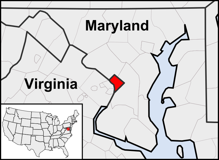
English: This is a map of the location of the District of Columbia showing the borders of states and counties around it.
تاریخ (UTC)
قایناق
یازار
آیری نوسخه‌لر

آثار انشقاقی از این پرونده:  United States geographical collation.svg All the below are of the states (and DC) only.
Blank US map.svg Map of states
Labelled US map.svg Map with state labels
USA_blank.svg Image with Hawaii and Alaska in full size
Original blank map of USA and Canada, That image with labels
Original with Hawaii at the natural distance, That original map with labels

File:DC locator map with state names w usmap.png and File:DC locator map with state names.jpg


این یک عکس دستکاری شده است به این معنی که به صورت دیجیتالی از نسخهٔ اصلی تغییر یافته‌است. تغییرها: Cropping to area around District of Columbia. اصل آن را می‌توان در اینجا مشاهده کرد: Blank USA, w territories.svg. تغییرها توسط Patrickneil انجام شده‌است.

w:azb:کریئیتیو کامنز
تخصیص بیرگه پایلاشیم
بو فایل کریتیو کامانز مجوز ایله Attribution-Share Alike 3.0 اویغونلاشمامیش یاییملانیب‌دیر.
سیزین ایجازه نیز وار دیر:
  • بؤلۆشمک – اثرین کپی، پایلاشماق و چاتدیرماسی اوچون
  • تلفیق ائت – اثرین توتوشدورماسی اوچون
آشاغی داکی شرایطله:
  • تخصیص – اثری مؤلف و یا لیسئنزییالی طرفین‌دن گؤستریلدیی کیمی ایستیناد ائتملیسینیز (آنجاق سنی دستکلدیینی و یا اثردن ایستیفاده ائتمیینیزی تکلیف ائتمملیسینیز).
  • بیرگه پایلاشیم – اگر بو اثرده دَییشدیرمه، چؤندرمه، یا دا کؤک‌دن دوزلتمه ائتسز، اله گلمیش اثری یالنیز بیر ائشیت یوخسا اوخشار بیر مجوزین آلتیندا یاییملایابیلرسینیز .

اورجینال یوکلمه گونده‌لیگی

This image is a derivative work of the following images:

  • File:USA_Counties.svg licensed with PD-USGov-DOC-Census
    • 2007-12-23T15:47:48Z Lokal Profil 555x352 (2124572 Bytes) Fixed state borders and fixed the two parts of Fulton County (Kentucky)
    • 2007-12-10T02:20:23Z Lokal Profil 555x352 (2136501 Bytes) Graphical and code cleanup
    • 2007-12-10T01:15:05Z Lokal Profil 792x612 (2135690 Bytes) First stab at a code cleanup
    • 2006-08-29T00:14:37Z Petr Dlouhý 792x612 (2844548 Bytes) Original file: [[:en:Image:USA CountiesSVG.zip]] This [[ZIP (file format)|ZIP]] file contains an [[SVG]] map of the [[United States]] showing the borders of states and counties in high detail. It was derived from [http://ww
  • File:Blank_USA,_w_territories.svg licensed with Cc-by-sa-3.0-migrated, GFDL
    • 2009-01-30T01:59:59Z Hoshie 959x593 (98189 Bytes) Reverted to version as of 23:58, 14 January 2009 - rv myself; DC can be seen clearly.
    • 2009-01-18T23:34:42Z Hoshie 959x593 (102341 Bytes) Put DC in an inset; fixed Tutuila (American Samoa)
    • 2009-01-14T23:58:05Z Lokal Profil 959x593 (98189 Bytes) Code cleanup and removed stroke from Guam and American Samoa
    • 2009-01-13T05:19:51Z Hoshie 959x593 (101361 Bytes) re did Guam and added American Samoa
    • 2007-12-02T16:08:45Z Lokal Profil 959x593 (88960 Bytes) {{Information |Description=A blank map of the United States including Puerto Rico, Guam, the United States Virgin Islands, and the Northern Mariana Islands. |Source=This version was made by [[:User:Lokal_Profil|Lokal_Profil]]

Uploaded with derivativeFX

عنوان

شرحی یک‌خطی از محتوای این فایل اضافه کنید

آیتم‌هایی که در این پرونده نمایش داده شده‌اند

توصیف‌ها فارسی

۱۲ آقوست 2010

فايل گئچمیشی

فايلین اول‌کی وئرسیياسینی گؤرمک اۆچون گۆن/تاریخ بؤلمه‌سینده‌کی تاریخلری تێقلايین.

(ان یئنی | ان اسکی) گؤستر (۱۰ داها یئنی | ) (۱۰ | ۲۰ | ۵۰ | ۱۰۰ | ۲۵۰ | ۵۰۰)
تاریخ/واختکیچیک عکساؤلچولرایشلدنباخیش
ایندیکی‏۲۳ جولای ۲۰۱۱، ساعت ۰۳:۲۳‏۲۳ جولای ۲۰۱۱، ساعت ۰۳:۲۳ تاریخینده‌کی سۆروموندن کیچیک گؤرونتوسو۷۵۰ در ۵۵۰ (۱۶۰ کیلوبایت)PatrickneilReverted to version as of 03:04, 23 July 2011
‏۲۳ جولای ۲۰۱۱، ساعت ۰۳:۲۱‏۲۳ جولای ۲۰۱۱، ساعت ۰۳:۲۱ تاریخینده‌کی سۆروموندن کیچیک گؤرونتوسو۷۵۰ در ۵۵۰ (۱۶۱ کیلوبایت)PatrickneilReverted to version as of 03:14, 23 July 2011
‏۲۳ جولای ۲۰۱۱، ساعت ۰۳:۲۰‏۲۳ جولای ۲۰۱۱، ساعت ۰۳:۲۰ تاریخینده‌کی سۆروموندن کیچیک گؤرونتوسو۷۵۰ در ۵۵۰ (۱۶۱ کیلوبایت)Patrickneilframe
‏۲۳ جولای ۲۰۱۱، ساعت ۰۳:۱۴‏۲۳ جولای ۲۰۱۱، ساعت ۰۳:۱۴ تاریخینده‌کی سۆروموندن کیچیک گؤرونتوسو۷۵۰ در ۵۵۰ (۱۶۱ کیلوبایت)Patrickneilthicker frame
‏۲۳ جولای ۲۰۱۱، ساعت ۰۳:۰۴‏۲۳ جولای ۲۰۱۱، ساعت ۰۳:۰۴ تاریخینده‌کی سۆروموندن کیچیک گؤرونتوسو۷۵۰ در ۵۵۰ (۱۶۰ کیلوبایت)Patrickneilstraightening Maryland and Delaware borders
‏۱۵ آقوست ۲۰۱۰، ساعت ۰۲:۰۹‏۱۵ آقوست ۲۰۱۰، ساعت ۰۲:۰۹ تاریخینده‌کی سۆروموندن کیچیک گؤرونتوسو۷۵۰ در ۵۵۰ (۲۰۲ کیلوبایت)PatrickneilDelaware River again
‏۱۵ آقوست ۲۰۱۰، ساعت ۰۱:۵۱‏۱۵ آقوست ۲۰۱۰، ساعت ۰۱:۵۱ تاریخینده‌کی سۆروموندن کیچیک گؤرونتوسو۷۵۰ در ۵۵۰ (۲۷۴ کیلوبایت)PatrickneilDelaware River border
‏۱۵ آقوست ۲۰۱۰، ساعت ۰۱:۴۲‏۱۵ آقوست ۲۰۱۰، ساعت ۰۱:۴۲ تاریخینده‌کی سۆروموندن کیچیک گؤرونتوسو۷۵۰ در ۵۵۰ (۲۷۳ کیلوبایت)Patrickneilforgot border on Smith Island
‏۱۵ آقوست ۲۰۱۰، ساعت ۰۱:۳۴‏۱۵ آقوست ۲۰۱۰، ساعت ۰۱:۳۴ تاریخینده‌کی سۆروموندن کیچیک گؤرونتوسو۷۵۰ در ۵۵۰ (۲۷۳ کیلوبایت)Patrickneilcounty borders below state
‏۱۵ آقوست ۲۰۱۰، ساعت ۰۱:۳۲‏۱۵ آقوست ۲۰۱۰، ساعت ۰۱:۳۲ تاریخینده‌کی سۆروموندن کیچیک گؤرونتوسو۷۵۰ در ۵۵۰ (۲۷۴ کیلوبایت)Patrickneilchanges by request
(ان یئنی | ان اسکی) گؤستر (۱۰ داها یئنی | ) (۱۰ | ۲۰ | ۵۰ | ۱۰۰ | ۲۵۰ | ۵۰۰)

آشاغیداکی صحیفه بو فایلا باغلانیر

فایلین باشاباش ایشلنیلمه‌سی

بو فایل آشاغی داکی آیری ویکی لرده ایشلَنیر:

بو فایلینسراسری ایستفاده لرینه باخین.