
فایل:Wpdms aq block 1614.jpg

سیناق گؤستریشی اؤلچوسو: ۴۲۹ × ۵۹۹ پیکسل. آیری کیفیتلر: ۱۷۲ × ۲۴۰ پیکسل | ۳۴۴ × ۴۸۰ پیکسل | ۵۵۰ × ۷۶۸ پیکسل | ۷۳۳ × ۱٬۰۲۴ پیکسل | ۱٬۴۶۶ × ۲٬۰۴۸ پیکسل | ۵٬۷۴۴ × ۸٬۰۲۱ پیکسل.
فایلین اصلی (۵٬۷۴۴ × ۸٬۰۲۱ پیکسل, فایل اؤلچوسو: ۷٫۶۱ مگابایت, MIME نوعو: image/jpeg)
قیساسی
| Description |
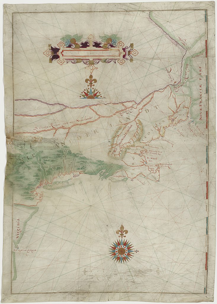
English: Map made by w:Adriaen Block of his 1614 expedition to North America. It is the first map to show Long Island as an island. It is also the first appearance of the term New Netherland to describe the colony (17th century drawing). |
|||||||||
| تاریخ | ||||||||||
| قایناق | digitalized by the Dutch National Archive (perm link) | |||||||||
| پدیدآورنده | ||||||||||
| Geotemporal data | ||||||||||
| Bounding box |
|
|||||||||
| Georeferencing | ||||||||||
| آیری نوسخهلر | File:The figurative map of Adriaen Block (NYPL Hades-118535-54659).tif | |||||||||
لیسانس
|
این اثر هنری دوبعدی که در این نگاره دیده میشود بخاطر تاریخ درگذشت پدیدآورنده آن یا تاریخ انتشارش هماکنون در سراسر جهان در مالکیت عمومی قرار دارد و استفاده از آن آزاد است.
بنابراین تکثیر آن در ایالات متحده آمریکا، آلمان و بسیاری کشورهای دیگر آزاد است.
| ||||
فايل گئچمیشی
فايلین اولکی وئرسیياسینی گؤرمک اۆچون گۆن/تاریخ بؤلمهسیندهکی تاریخلری تێقلايین.
| تاریخ/واخت | کیچیک عکس | اؤلچولر | ایشلدن | باخیش | |
|---|---|---|---|---|---|
| ایندیکی | ۱۸ مئی ۲۰۲۱، ساعت ۱۸:۴۱ | | ۵٬۷۴۴ در ۸٬۰۲۱ (۷٫۶۱ مگابایت) | Ciell | Larger digitalisation from the Dutch National Archive |
| ۱۷ فوریه ۲۰۱۲، ساعت ۱۷:۱۵ |  | ۴۵۶ در ۶۴۰ (۱۰۴ کیلوبایت) | Gladiool | Better quality version of the same image. Found at [http://www.stonybrook.edu/libmap/coordinates/seriesa/no5/block.jpg]. | |
| ۲۸ سپتامبر ۲۰۰۵، ساعت ۲۱:۰۰ |  | ۳۵۰ در ۴۹۹ (۳۱ کیلوبایت) | Longbow4u | *Description:Map made by w:Adriaen Block of his 1614 expedition to North America. It is the first map to show Long Island as an island. It is also the first appearance of the term New Netherland to describe the colony (17th century drawing). *Sour |
فايل ایشلدمهسی
آشاغیداکی صحیفه بو فایلا باغلانیر
فایلین باشاباش ایشلنیلمهسی
بو فایل آشاغی داکی آیری ویکی لرده ایشلَنیر:
- af.wikipedia.org-ده ایشلنمهسی
- be.wikipedia.org-ده ایشلنمهسی
- ca.wikipedia.org-ده ایشلنمهسی
- de.wikipedia.org-ده ایشلنمهسی
- en.wikipedia.org-ده ایشلنمهسی
- es.wikipedia.org-ده ایشلنمهسی
- et.wikipedia.org-ده ایشلنمهسی
- fa.wikipedia.org-ده ایشلنمهسی
- fr.wikipedia.org-ده ایشلنمهسی
- fy.wikipedia.org-ده ایشلنمهسی
- hr.wikipedia.org-ده ایشلنمهسی
- is.wikipedia.org-ده ایشلنمهسی
- it.wikipedia.org-ده ایشلنمهسی
- ja.wikipedia.org-ده ایشلنمهسی
- ml.wikipedia.org-ده ایشلنمهسی
- nl.wikipedia.org-ده ایشلنمهسی
- ru.wikipedia.org-ده ایشلنمهسی
- sh.wikipedia.org-ده ایشلنمهسی
- uk.wikipedia.org-ده ایشلنمهسی
- zh.wikipedia.org-ده ایشلنمهسی