مرزق، لیبی: نوسخهلر آراسینداکی فرق
محتوای حذفشده محتوای افزودهشده
4321bot (دانیشیق | چالیشمالار) ک ←top: آفریقا شهرلری |
4321bot (دانیشیق | چالیشمالار) ک ←top: آفریقا شهرلرین بیلگی قوتوسون ایضافه ائددیم. |
||
| خط ۱: | خط ۱: | ||
{{Infobox settlement |
|||
<!--See the Table at Infobox Settlement for all fields and descriptions of usage--> |
|||
<!--Basic info----------------> |
|||
|official_name = Murzuk |
|||
|other_name = Murzuch |
|||
|native_name = مرزق |
|||
|nickname = |
|||
|settlement_type = Town<!--For Town or Village (Leave blank for the default City)--> |
|||
|motto = |
|||
<!--images and maps-----------> |
|||
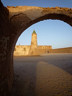
|image_skyline = Murzuq - Moschee und Festung Qala at Turk.jpg |
|||
|imagesize = |
|||
|image_caption = Fort and mosque of Murzuk |
|||
|image_flag = |
|||
|flag_size = |
|||
|image_seal = |
|||
|seal_size = |
|||
|image_shield = |
|||
|shield_size = |
|||
|image_blank_emblem = |
|||
|blank_emblem_type = |
|||
|blank_emblem_size = |
|||
|image_map = |
|||
|mapsize = |
|||
|map_caption = |
|||
|image_map1 = |
|||
|mapsize1 = |
|||
|map_caption1 = |
|||
|image_dot_map = |
|||
|dot_mapsize = |
|||
|dot_map_caption = |
|||
|dot_x = |dot_y = |
|||
|pushpin_map = Libya<!-- the name of a location map as per http://en.wikipedia.org/wiki/Template:Location_map --> |
|||
|pushpin_label_position = bottom |
|||
|pushpin_map_caption = Location in Libya |
|||
<!--Location------------------> |
|||
|subdivision_type = Country |
|||
|subdivision_name = {{flag|Libya}} |
|||
|subdivision_type1 = Region |
|||
|subdivision_name1 = [[Fezzan]] |
|||
|subdivision_type2 = [[Districts of Libya|District]] |
|||
|subdivision_name2 = [[Murzuq District|Murzuq]] |
|||
|subdivision_type3 = |
|||
|subdivision_name3 = |
|||
|subdivision_type4 = |
|||
|subdivision_name4 = |
|||
<!--Politics-----------------> |
|||
|government_footnotes = |
|||
|government_type = |
|||
|leader_title = |
|||
|leader_name = |
|||
|leader_title1 = <!-- for places with, say, both a mayor and a city manager --> |
|||
|leader_name1 = |
|||
|leader_title2 = |
|||
|leader_name2 = |
|||
|leader_title3 = |
|||
|leader_name3 = |
|||
|leader_title4 = |
|||
|leader_name4 = |
|||
|established_title = <!--Settled--> |
|||
|established_date = |
|||
|established_title2 = <!--Incorporated (town)--> |
|||
|established_date2 = |
|||
|established_title3 = <!--Incorporated (city)--> |
|||
|established_date3 = |
|||
<!--Area---------------------> |
|||
|area_magnitude = |
|||
|unit_pref = Imperial <!--Enter: Imperial, if Imperial (metric) is desired--> |
|||
|area_footnotes = |
|||
|area_total_km2 = <!-- ALL fields dealing with a measurements are subject to automatic unit conversion--> |
|||
|area_land_km2 = <!--See table @ Template:Infobox Settlement for details on automatic unit conversion--> |
|||
|area_water_km2 = |
|||
|area_total_sq_mi = |
|||
|area_land_sq_mi = |
|||
|area_water_sq_mi = |
|||
|area_water_percent = |
|||
|area_urban_km2 = |
|||
|area_urban_sq_mi = |
|||
|area_metro_km2 = |
|||
|area_metro_sq_mi = |
|||
|area_blank1_title = |
|||
|area_blank1_km2 = |
|||
|area_blank1_sq_mi = |
|||
<!--Population-----------------------> |
|||
|population_as_of = 2011 |
|||
|population_footnotes = <ref>{{cite web|url=http://www.world-gazetteer.com/wg.php?x=1273372850&men=gpro&lng=en&des=gamelan&geo=-133&srt=dpnn&col=abcdefghimoq&msz=1500&pt=c&va=&geo=417331392|title=World Gazeteer|archiveurl=https://archive.today/20130105095247/http://www.world-gazetteer.com/wg.php?x=1273372850&men=gpro&lng=en&des=gamelan&geo=-133&srt=dpnn&col=abcdefghimoq&msz=1500&pt=c&va=&geo=417331392|archivedate=5 January 2013|deadurl=yes|df=}}</ref> |
|||
|population_note = |
|||
|population_total = 12,746 |
|||
|population_density_km2 = |
|||
|population_density_sq_mi = |
|||
|population_metro = |
|||
|population_density_metro_km2 = |
|||
|population_density_metro_sq_mi = |
|||
|population_urban = |
|||
|population_density_urban_km2 = |
|||
|population_density_urban_sq_mi = |
|||
|population_blank1_title = Ethnicities |
|||
|population_blank1 = |
|||
|population_blank2_title = Religions |
|||
|population_blank2 = |
|||
|population_density_blank1_km2 = |
|||
|population_density_blank1_sq_mi = |
|||
<!--General information---------------> |
|||
| timezone= [[Eastern European Time|EET]] |
|||
| utc_offset = +2 |
|||
|timezone_DST = |
|||
|utc_offset_DST = |
|||
|coordinates = {{coord|25|54|49|N|13|55|01|E|region:LY|display=inline}} |
|||
|elevation_footnotes = <ref name=wolfram>[http://www.wolframalpha.com/input/?i=Marzuq Wolfram Alpha]</ref> |
|||
|elevation_m = 453 |
|||
|elevation_ft = |
|||
<!--Area/postal codes & others--------> |
|||
|postal_code_type = <!--enter ZIP code, Postcode, Post code, Postal code...--> |
|||
|postal_code = |
|||
|area_code = |
|||
|blank_name = |
|||
|blank_info = |
|||
|blank1_name = |
|||
|blank1_info = |
|||
|website = |
|||
|footnotes = |
|||
}} |
|||
'''مرزق، لیبی''' ([[اینگیلیس دیلی|اینگیلیسیجه]]: Murzuk) [[لیبی]] اؤلکهسینین شهرلریندن بیریدیر. دنیز سَویهسیندن ۴۵۳ متر یۆکسکلیکده قۇرولان شهر سوْن نۆفوس ساییمینا گؤره توْپلام جمعیتی ۱۲٬۷۴۶ نفردیر. |
'''مرزق، لیبی''' ([[اینگیلیس دیلی|اینگیلیسیجه]]: Murzuk) [[لیبی]] اؤلکهسینین شهرلریندن بیریدیر. دنیز سَویهسیندن ۴۵۳ متر یۆکسکلیکده قۇرولان شهر سوْن نۆفوس ساییمینا گؤره توْپلام جمعیتی ۱۲٬۷۴۶ نفردیر. |
||
۸ ژوئن ۲۰۱۹، ساعت ۰۹:۳۴ نوسخهسی
Murzuk
مرزق Murzuch | |
|---|---|
Town | |
 Fort and mosque of Murzuk | |
| موختصاتلار: 25°54′49″N 13°55′01″E / 25.91361°N 13.91694°E | |
| Country | |
| Region | Fezzan |
| District | Murzuq |
| اوجالیق | ۱٬۴۸۶ ft (۴۵۳ m) |
| جمعیت (2011)[۲] | |
| • جمع | ۱۲٬۷۴۶ |
| ساعات قورشاغی | یوتیسی +2 (EET) |
مرزق، لیبی (اینگیلیسیجه: Murzuk) لیبی اؤلکهسینین شهرلریندن بیریدیر. دنیز سَویهسیندن ۴۵۳ متر یۆکسکلیکده قۇرولان شهر سوْن نۆفوس ساییمینا گؤره توْپلام جمعیتی ۱۲٬۷۴۶ نفردیر.
قایناقلار
- ^ Wolfram Alpha
- ^ World Gazeteer. آرشیولنیب اصلی نۆسخهدن on 5 January 2013.
| بو آفریقا ایله باغلی مقاله، بیر قارالاما مقاله دیر. بونو گئنیشلندیرمکله ویکیپدیایا کؤمک ائده بیلرسینیز. |

