بریجند
Bridgend
| |
|---|---|
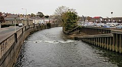
 The Ogmore River. To the left of the river is Quarella Road; to the right, a superstore and car park | |
 The Old Bridge was built in 1425, repaired in 1775 and restored in 2005 | |
| لوآ خطاسیماژول:Location_map-ین 522-جی/جو خطینده: Unable to find the specified location map definition: "Module:Location map/data/Wales" does not exist. | |
| جمعیت | ۴۹٬۴۰۴ (April 2011)[۱] |
| OS grid reference | SS905805 |
| Community | |
| Principal area | |
| Preserved county | |
| اؤلکه | Wales |
| موستقیل دوولت | United Kingdom |
| Post town | BRIDGEND |
| Postcode district | CF31-33, CF35 |
| تیلفون کودو | 01656 |
| Ambulance | Welsh |
| UK Parliament | |
| Senedd Cymru – Welsh Parliament | |
بریجند (اینگیلیسیجه: Bridgend) بریتانیادا بیر یاشاییش منطقهسیدیر سوْن نۆفوس تخمینلرینه گؤره 49404 نفر دیر. بۇ شهر ولز اؤلکهسینده یئرلشیب.
گؤرونتولر[دَییشدیر]
بیرده باخ[دَییشدیر]
قایناقلار[دَییشدیر]
- ^ Key Statistics for urban areas in England and Wales. Census 2011. UK Office for National Statistics. آرشیولنیب اصلی نۆسخهدن on 2014-10-18. یوْخلانیلیب4 September 2013.
| بو شهرلر ایله باغلی مقاله، بیر قارالاما مقاله دیر. بونو گئنیشلندیرمکله ویکیپدیایا کؤمک ائده بیلرسینیز. |


