
فایل:1857 U.S. Coast Survey Map of San Antonio Creek and Oakland, California (near San Francisco) - Geographicus - SanAntonioCreek-uscs-1857.jpg

فایلین اصلی (۴٬۰۰۰ × ۲٬۸۷۹ پیکسل, فایل اؤلچوسو: ۴٫۳۸ مگابایت, MIME نوعو: image/jpeg)
_-_Geographicus_-_SanAntonioCreek-uscs-1857.jpg)
| San Antonio Creek California. | ||||||
|---|---|---|---|---|---|---|
| آرتیست | ||||||
| باشلیق |
San Antonio Creek California. |
|||||
| آچیقلاما |
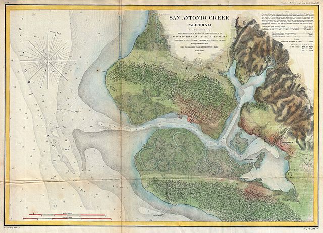
English: This is a rare 1857 U.S. Coast Survey chart of San Antonio Creek and Oakland, California. Oakland is an important Bay area city located directly east of San Francisco, just across the bay. Also shows Brooklyn, CA, and the road to San Jose, CA. Offers excellent inland detail, to the level of individual buildings, especially in the city of Oakland. Depth soundings throughout. The triangulation for this chart was accomplished by R. D. Cutts. The topography is the work A. F. Rodgers. The Hydrography was completed by a party under the command of James Alden. The entire work was produced in 1857 under the direction of A. D. Bache, superintendent of the United States Coast Survey. |
|||||
| تاریخ | ۱۸۵۷ (dated) | |||||
| اؤلچولر | بلندی: ۱۳٫۵ اینچ (۳۴٫۲ سانتیمتر)؛ عرض: ۱۹٫۲ اینچ (۴۸٫۸ سانتیمتر) | |||||
| آیدی |
Geographicus link: SanAntonioCreek-uscs-1857 |
|||||
| منبع/عکاس |
Report of the Superintendant of the U.S. Coast Survey, (1857 edition).
|
|||||
| ایجازه (فایلین تکرار ایستیفادهسی) |
|
|||||
فايل گئچمیشی
فايلین اولکی وئرسیياسینی گؤرمک اۆچون گۆن/تاریخ بؤلمهسیندهکی تاریخلری تێقلايین.
| تاریخ/واخت | کیچیک عکس | اؤلچولر | ایشلدن | باخیش | |
|---|---|---|---|---|---|
| ایندیکی | ۱۶ مارس ۲۰۱۱، ساعت ۱۹:۵۱ | | ۴٬۰۰۰ در ۲٬۸۷۹ (۴٫۳۸ مگابایت) | BotMultichill | {{subst:User:Multichill/Geographicus |link=http://www.geographicus.com/P/AntiqueMap/SanAntonioCreek-uscs-1857 |product_name=1857 U.S. Coast Survey Map of San Antonio Creek and Oakland, California (near San Francisco) |map_title=San Antonio Creek Californi |
فايل ایشلدمهسی
آشاغیداکی صحیفه بو فایلا باغلانیر
فایلین باشاباش ایشلنیلمهسی
بو فایل آشاغی داکی آیری ویکی لرده ایشلَنیر:
- en.wikipedia.org-ده ایشلنمهسی
- mk.wikipedia.org-ده ایشلنمهسی
- pa.wikipedia.org-ده ایشلنمهسی
- pnb.wikipedia.org-ده ایشلنمهسی
_-_Geographicus_-_SanAntonioCreek-uscs-1857.jpg)