
فایل:215 Miles from Southport - geograph.org.uk - 515415.jpg
یوخاری کیفیت الده یوخدور.
215_Miles_from_Southport_-_geograph.org.uk_-_515415.jpg (۶۴۰ × ۴۵۲ پیکسل, فایل اؤلچوسو: ۷۹ کیلوبایت, MIME نوعو: image/jpeg)
This is a photo of listed building number 1249389. |
قیساسی
| آچیقلاما |
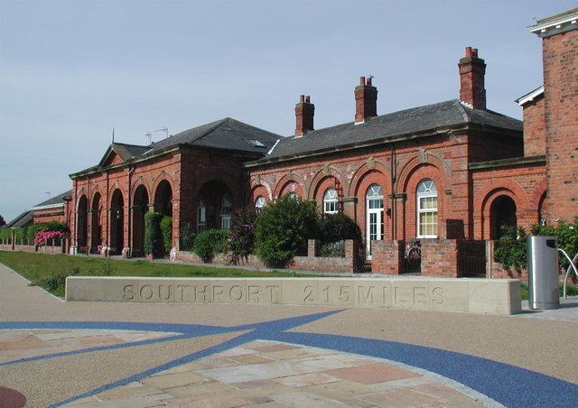
English: 215 Miles from Southport, Hornsea, East Riding of Yorkshire, England. Part of the installation at the old Hornsea Railway Station marking the end of the Trans Pennine Trail. The trail which runs for 215 miles from Hornsea to Southport officially opened in September 2001 after twelve years of planning and development. There are actually three locations in Hornsea where the eastern end of the trail is marked: as well as this one there is a tall metallic sculpture on the seafront and also a small and rather dull concrete plinth outside Hornsea Leisure Centre on Sands Lane. In 1846 the York & North Midland Railway Co. was granted permission to build a railway line from Beverley to Hornsea, and in 1861 Joseph Armytage Wade promoted the building of a line from Hornsea to Hull and the Hull & Hornsea Railway Co. was formed. The line opened in 1864 with this station close to the sea and another at Hornsea Bridge at the junction of Southgate and Rolston Road. After little or no financial success the company merged with North Eastern Railway in 1866. The seafront terminus closed in 1964 and Hornsea Bridge Station the following year. Hornsea Bridge Station has been demolished and the buildings here at the terminus converted into housing. |
| تاریخ | |
| قایناق | From geograph.org.uk |
| یازار | Paul Glazzard |
| ایجازه (فایلین تکرار ایستیفادهسی) |
Creative Commons Attribution Share-alike license 2.0 |
| موجَویز (required by the license) | Paul Glazzard / 215 Miles from Southport / |
| مختصات دوربین | | محل قرارگیری این نگاره و سایر نگارهها در: نقشهٔ شهری باز |
|---|
_heading:225.00&language=azb)
| مختصات شیء | | محل قرارگیری این نگاره و سایر نگارهها در: نقشهٔ شهری باز |
|---|
_heading:225.00&language=azb)
لیسانس

|
این نگاره از مجموعهٔ پروژهٔ Geograph گرفته شدهاست. این صفحهٔ عکسها را در وبگاه Geograph برای جزئیات تماس با عکاس ببینید. حق تکثیر این تصویر به Paul Glazzard تعلق دارد و برای استفادهٔ مجدد تحت Creative Commons Attribution-ShareAlike 2.0 مجوزدهی شدهاست.
|
این پرونده با اجازهنامهٔ کریتیو کامانز Attribution-Share Alike 2.0 عمومی منتشر شده است.
موجَویز: Paul Glazzard
- سیزین ایجازه نیز وار دیر:
- بؤلۆشمک – اثرین کپی، پایلاشماق و چاتدیرماسی اوچون
- تلفیق ائت – اثرین توتوشدورماسی اوچون
- آشاغی داکی شرایطله:
- تخصیص – اثری مؤلف و یا لیسئنزییالی طرفیندن گؤستریلدیی کیمی ایستیناد ائتملیسینیز (آنجاق سنی دستکلدیینی و یا اثردن ایستیفاده ائتمیینیزی تکلیف ائتمملیسینیز).
- بیرگه پایلاشیم – اگر بو اثرده دَییشدیرمه، چؤندرمه، یا دا کؤکدن دوزلتمه ائتسز، اله گلمیش اثری یالنیز بیر ائشیت یوخسا اوخشار بیر مجوزین آلتیندا یاییملایابیلرسینیز .
فايل گئچمیشی
فايلین اولکی وئرسیياسینی گؤرمک اۆچون گۆن/تاریخ بؤلمهسیندهکی تاریخلری تێقلايین.
| تاریخ/واخت | کیچیک عکس | اؤلچولر | ایشلدن | باخیش | |
|---|---|---|---|---|---|
| ایندیکی | ۵ فوریه ۲۰۱۱، ساعت ۱۱:۴۹ | | ۶۴۰ در ۴۵۲ (۷۹ کیلوبایت) | GeographBot | == {{int:filedesc}} == {{Information |description={{en|1=215 Miles from Southport Part of the installation at the old Hornsea Railway Station marking the end of the Trans Pennine Trail. The trail which runs for 215 miles from Hornsea to Southport official |
فايل ایشلدمهسی
آشاغیداکی صحیفه بو فایلا باغلانیر
فایلین باشاباش ایشلنیلمهسی
بو فایل آشاغی داکی آیری ویکی لرده ایشلَنیر:
- en.wikipedia.org-ده ایشلنمهسی