
فایل:CIRCASSIA1840.jpg
فایلین اصلی (۶٬۳۴۸ × ۳٬۰۴۷ پیکسل, فایل اؤلچوسو: ۵۴۴ کیلوبایت, MIME نوعو: image/jpeg)
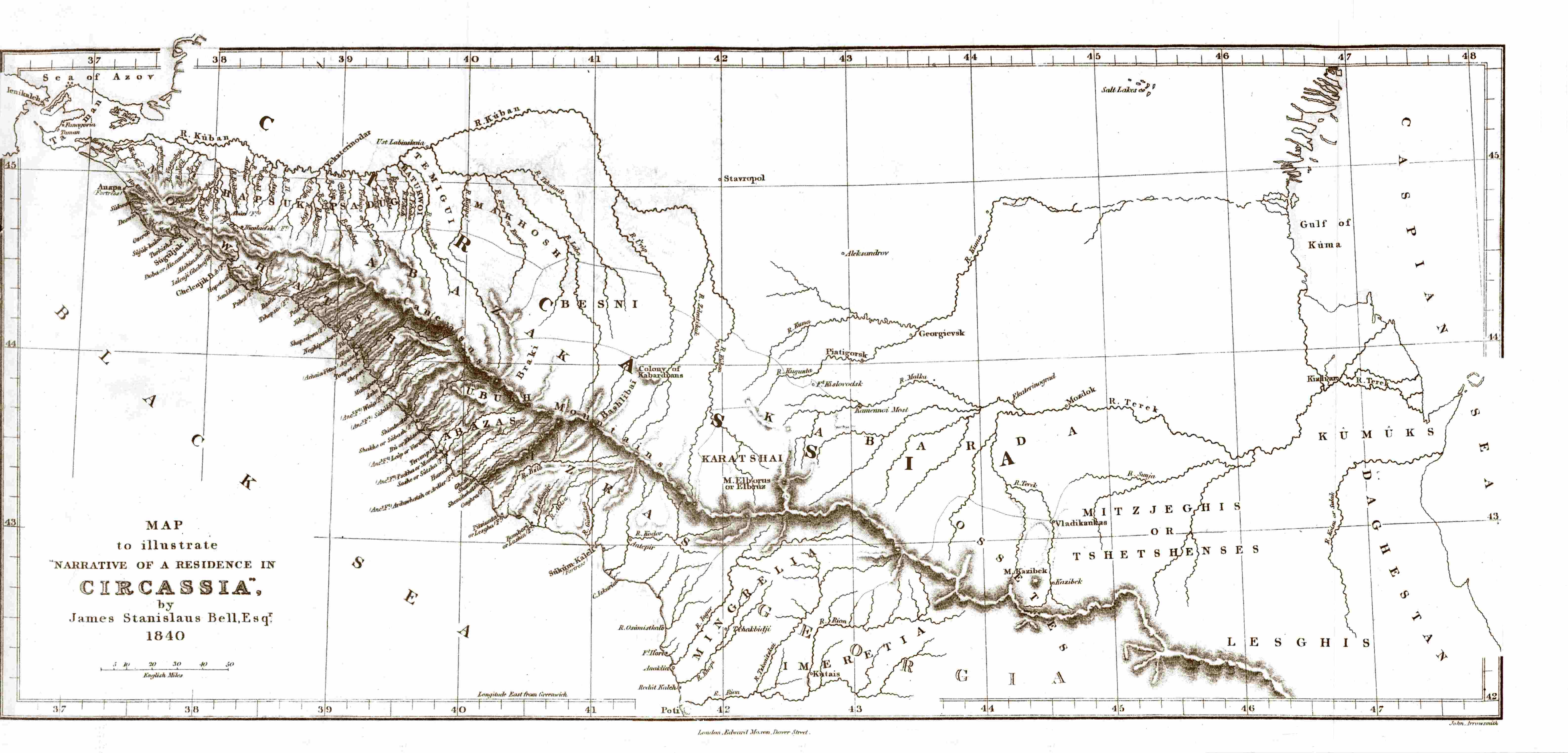
| آچیقلاما | Map of Circassia, made in 1840 during the en:Russian-Circassian War, PD due to author's death over 100 years ago. Found here, lon. 36.5° - 48° E, lat. 42° - 45.5° N | ||||
| تاریخ | ۵ مئی ۲۰۰۷ (تاریخ اصلی بارگذاری) | ||||
| قایناق | Transferred from en.wikipedia to Commons. | ||||
| یازار |
James Stanislaus Bell (1797-1858) |
||||
| ایجازه (فایلین تکرار ایستیفادهسی) |
|
||||
اورجینال یوکلمه گوندهلیگی
- 2007-05-05 20:44 SGGH 6348×3047×8 (556561 bytes) Map of Circassia, made in 1840 during the [[Russian-Circassian War]], PD due to author's death over 100 years ago. Found [http://www.circassianworld.com/CIRCASSIA1840.jpg here]
فايل گئچمیشی
فايلین اولکی وئرسیياسینی گؤرمک اۆچون گۆن/تاریخ بؤلمهسیندهکی تاریخلری تێقلايین.
| تاریخ/واخت | کیچیک عکس | اؤلچولر | ایشلدن | باخیش | |
|---|---|---|---|---|---|
| ایندیکی | ۲ ژانویه ۲۰۱۴، ساعت ۱۹:۴۹ | | ۶٬۳۴۸ در ۳٬۰۴۷ (۵۴۴ کیلوبایت) | Don-kun | Reverted Vandalism; this is an original map which cannot be replaced by some totally different map |
| ۲۰ اوْکتوبر ۲۰۱۳، ساعت ۱۶:۰۸ |  | ۷۶۸ در ۵۲۸ (۷۱ کیلوبایت) | Руслан Шаов | Черкесия.1700 года | |
| ۸ جولای ۲۰۰۷، ساعت ۰۹:۴۳ |  | ۶٬۳۴۸ در ۳٬۰۴۷ (۵۴۴ کیلوبایت) | Hardscarf | {{Information |Description=Map of Circassia, made in 1840 during the en:Russian-Circassian War, PD due to author's death over 100 years ago. Found [http://www.circassianworld.com/CIRCASSIA1840.jpg here] |Source=Originally from [http://en.wikipedia.or |
فايل ایشلدمهسی
آشاغیداکی صحیفه بو فایلا باغلانیر
فایلین باشاباش ایشلنیلمهسی
بو فایل آشاغی داکی آیری ویکی لرده ایشلَنیر:
- ar.wikipedia.org-ده ایشلنمهسی
- av.wikipedia.org-ده ایشلنمهسی
- ba.wikipedia.org-ده ایشلنمهسی
- br.wikipedia.org-ده ایشلنمهسی
- de.wikipedia.org-ده ایشلنمهسی
- en.wikipedia.org-ده ایشلنمهسی
- es.wikipedia.org-ده ایشلنمهسی
- fi.wikipedia.org-ده ایشلنمهسی
- fr.wikipedia.org-ده ایشلنمهسی
- he.wikipedia.org-ده ایشلنمهسی
- hu.wikipedia.org-ده ایشلنمهسی
- it.wikipedia.org-ده ایشلنمهسی
- ka.wikipedia.org-ده ایشلنمهسی
- kbd.wikipedia.org-ده ایشلنمهسی
- lt.wikipedia.org-ده ایشلنمهسی
- nl.wikipedia.org-ده ایشلنمهسی
- pl.wikipedia.org-ده ایشلنمهسی
- pnb.wikipedia.org-ده ایشلنمهسی
- ro.wikipedia.org-ده ایشلنمهسی
- ru.wikipedia.org-ده ایشلنمهسی
- sl.wikipedia.org-ده ایشلنمهسی
- tr.wikipedia.org-ده ایشلنمهسی
- uk.wikipedia.org-ده ایشلنمهسی
- ur.wikipedia.org-ده ایشلنمهسی