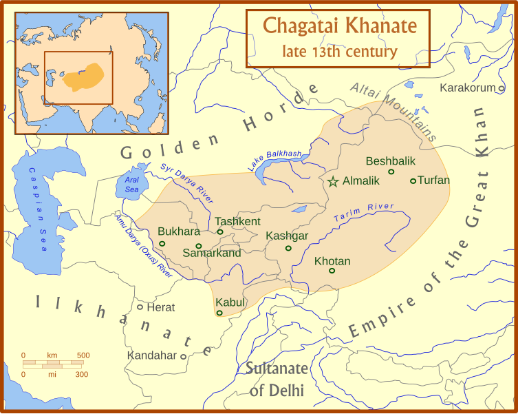
فایل:Chagatai Khanate map en.svg

حجم پیشنمایش PNG این SVG file:۷۵۳ × ۶۰۰ پیکسل آیری کیفیتلر: ۳۰۱ × ۲۴۰ پیکسل | ۶۰۳ × ۴۸۰ پیکسل | ۹۶۴ × ۷۶۸ پیکسل | ۱٬۲۸۰ × ۱٬۰۲۰ پیکسل | ۲٬۵۶۰ × ۲٬۰۳۹ پیکسل | ۸۱۱ × ۶۴۶ پیکسل.
فایلین اصلی (SVG فایلی، ۸۱۱ × ۶۴۶ پیکسئل، فایلین اؤلچوسو: ۴۶۸ کیلوبایت)
فايل گئچمیشی
فايلین اولکی وئرسیياسینی گؤرمک اۆچون گۆن/تاریخ بؤلمهسیندهکی تاریخلری تێقلايین.
| تاریخ/واخت | کیچیک عکس | اؤلچولر | ایشلدن | باخیش | |
|---|---|---|---|---|---|
| ایندیکی | ۱۵ جولای ۲۰۰۸، ساعت ۰۴:۵۰ |  | ۸۱۱ در ۶۴۶ (۴۶۸ کیلوبایت) | MapMaster | +river name, + colour adjustment |
| ۱۵ جولای ۲۰۰۸، ساعت ۰۴:۱۳ |  | ۸۱۱ در ۶۴۶ (۴۵۴ کیلوبایت) | MapMaster | made a few corrections to version | |
| ۱۵ جولای ۲۰۰۸، ساعت ۰۴:۰۷ |  | ۸۱۱ در ۶۴۶ (۴۲۶ کیلوبایت) | MapMaster | {{Information |Description={{en|1=A map of the Chagatai Khanate, late 13th century}} |Source=Own work by uploader |Author=MapMaster |Date=14 July 2008 |Permission= |other_versions= }} {{ImageUpload|full}} |
فايل ایشلدمهسی
آشاغیداکی صحیفه بو فایلا باغلانیر
فایلین باشاباش ایشلنیلمهسی
بو فایل آشاغی داکی آیری ویکی لرده ایشلَنیر:
- az.wikipedia.org-ده ایشلنمهسی
- bg.wikipedia.org-ده ایشلنمهسی
- bn.wikipedia.org-ده ایشلنمهسی
- ca.wikipedia.org-ده ایشلنمهسی
- ce.wikipedia.org-ده ایشلنمهسی
- crh.wikipedia.org-ده ایشلنمهسی
- da.wikipedia.org-ده ایشلنمهسی
- de.wikipedia.org-ده ایشلنمهسی
- el.wikipedia.org-ده ایشلنمهسی
- en.wikipedia.org-ده ایشلنمهسی
- eo.wikipedia.org-ده ایشلنمهسی
- et.wikipedia.org-ده ایشلنمهسی
- fr.wikipedia.org-ده ایشلنمهسی
- he.wikipedia.org-ده ایشلنمهسی
- hi.wikipedia.org-ده ایشلنمهسی
- hr.wikipedia.org-ده ایشلنمهسی
- hu.wikipedia.org-ده ایشلنمهسی
- it.wikipedia.org-ده ایشلنمهسی
- ja.wikipedia.org-ده ایشلنمهسی
- kk.wikipedia.org-ده ایشلنمهسی
- ko.wikipedia.org-ده ایشلنمهسی
- lt.wikipedia.org-ده ایشلنمهسی
- mk.wikipedia.org-ده ایشلنمهسی
- mn.wikipedia.org-ده ایشلنمهسی
- nl.wikipedia.org-ده ایشلنمهسی
- oc.wikipedia.org-ده ایشلنمهسی
- pl.wikipedia.org-ده ایشلنمهسی
- pnb.wikipedia.org-ده ایشلنمهسی
- ru.wikipedia.org-ده ایشلنمهسی
بو فایلینسراسری ایستفاده لرینه باخین.
