
فایل:Crawley Neighbourhoods with Colours.png
یوخاری کیفیت الده یوخدور.
Crawley_Neighbourhoods_with_Colours.png (۲۶۰ × ۲۷۷ پیکسل, فایل اؤلچوسو: ۶ کیلوبایت, MIME نوعو: image/png)
قیساسی
| آچیقلاما |
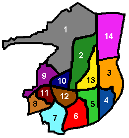
English: Diagram of Crawley's 13 residential neighbourhoods, showing the colours used by the council on road name signs to distinguish between them. Created by Hassocks5489 based on an original diagram by Radamfi. Created 22 September 2007. |
| تاریخ | ۲۲ سپتامبر ۲۰۰۷ (تاریخ اصلی بارگذاری) |
| قایناق | یوکلهیهنین اؤز ایشی |
| یازار | Hassocks5489 در ویکیپدیا انگلیسی |
لیسانس
| این اثر توسط پدیدآور آن، Hassocks5489 در ویکیپدیا انگلیسی، به مالکیت عمومی درآمده است. این مربوط به تمام جهان است. در برخی از کشورها ممکن است به صورت قانونی این امکانپذیر نباشد؛ اگر چنین است: Hassocks5489 به هر کسی اجازهٔ استفاده از این اثر برای هر مقصودی، بدون هیچگونه شرایطی، را میدهد تا وقتی که این شرایط توسط قانون مستلزم نشده باشند. |
اورجینال یوکلمه گوندهلیگی
The original description page was here. All following user names refer to en.wikipedia.
- 2007-09-22 11:55 Hassocks5489 260×277 (5338 bytes) Diagram of Crawley's 13 residential neighbourhoods, showing the colours used by the council on road name signs to distinguish between them. Created by Hassocks5489 based on an original diagram by Radamfi. Created [[22 September]] [[2007]].
- 2008-04-08 16:33 Smjg 260×277 (5383 bytes) Diagram of Crawley's 13 residential neighbourhoods, showing the colours used by the council on road name signs to distinguish between them. Created by Hassocks5489 based on an original diagram by Radamfi. Created [[22 September]] [[2007]]. Colours corr
فايل گئچمیشی
فايلین اولکی وئرسیياسینی گؤرمک اۆچون گۆن/تاریخ بؤلمهسیندهکی تاریخلری تێقلايین.
| تاریخ/واخت | کیچیک عکس | اؤلچولر | ایشلدن | باخیش | |
|---|---|---|---|---|---|
| ایندیکی | ۱۶ اوْکتوبر ۲۰۱۹، ساعت ۲۲:۴۳ | | ۲۶۰ در ۲۷۷ (۶ کیلوبایت) | Gamingmoor | Added Forgewood area |
| ۲ ژانویه ۲۰۱۱، ساعت ۱۶:۴۶ |  | ۲۶۰ در ۲۷۷ (۵ کیلوبایت) | BotMultichill | {{BotMoveToCommons|en.wikipedia|year={{subst:CURRENTYEAR}}|month={{subst:CURRENTMONTHNAME}}|day={{subst:CURRENTDAY}}}} == {{int:filedesc}} == {{Information |description={{en|1=Diagram of Crawley's 13 residential neighbourhoods, showing the colours used b |
فايل ایشلدمهسی
آشاغیداکی صحیفه بو فایلا باغلانیر
فایلین باشاباش ایشلنیلمهسی
بو فایل آشاغی داکی آیری ویکی لرده ایشلَنیر: