
فایل:Doughoregan.jpg
یوخاری کیفیت الده یوخدور.
Doughoregan.jpg (۵۰۸ × ۴۰۸ پیکسل, فایل اؤلچوسو: ۵۴ کیلوبایت, MIME نوعو: image/jpeg)
|
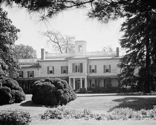
This is an image of a place or building that is listed on the National Register of Historic Places in the United States of America. Its reference number is 71000376. |
| آچیقلاما | ||||||
| تاریخ | ||||||
| قایناق |
|
|||||
| یازار | E.H. Pickering | |||||
| ایجازه (فایلین تکرار ایستیفادهسی) |
|


| مختصات شیء | | محل قرارگیری این نگاره و سایر نگارهها در: نقشهٔ شهری باز |
|---|
| این یک عکس دستکاری شده است به این معنی که به صورت دیجیتالی از نسخهٔ اصلی تغییر یافتهاست. تغییرها: cropped. تغییرها توسط Eoghanacht انجام شدهاست.
|
اورجینال یوکلمه گوندهلیگی
صفحهٔ اصلی توضیحات اینجابود. همهٔ نامهای کاربر زیر به en.wikipedia اشاره دارند.
- 2005-08-04 13:26 Eoghanacht 508×408× (55370 bytes) [[Doughoregan Manor]] ([[Historic American Buildings Survey]], photographer E.H. Pickering, Sept. 1936, survey number HABS MD-230) {{PD-USGov-Interior-NPS}} [[Category:U.S. National Historic Landmarks]]
فايل گئچمیشی
فايلین اولکی وئرسیياسینی گؤرمک اۆچون گۆن/تاریخ بؤلمهسیندهکی تاریخلری تێقلايین.
| تاریخ/واخت | کیچیک عکس | اؤلچولر | ایشلدن | باخیش | |
|---|---|---|---|---|---|
| ایندیکی | ۲۶ مارس ۲۰۰۹، ساعت ۲۱:۱۶ | | ۵۰۸ در ۴۰۸ (۵۴ کیلوبایت) | File Upload Bot (Magnus Manske) | {{BotMoveToCommons|en.wikipedia|year={{subst:CURRENTYEAR}}|month={{subst:CURRENTMONTHNAME}}|day={{subst:CURRENTDAY}}}} {{Information |Description={{en|en:Doughoregan Manor (en:Historic American Buildings Survey, photographer E.H. Pickering, Sep |
فايل ایشلدمهسی
آشاغیداکی صحیفه بو فایلا باغلانیر
فایلین باشاباش ایشلنیلمهسی
بو فایل آشاغی داکی آیری ویکی لرده ایشلَنیر:
- ca.wikipedia.org-ده ایشلنمهسی
- de.wikipedia.org-ده ایشلنمهسی
- en.wikipedia.org-ده ایشلنمهسی
- Charles Carroll of Carrollton
- Doughoregan Manor
- List of National Historic Landmarks in Maryland
- National Register of Historic Places listings in Howard County, Maryland
- List of plantations in the United States
- Charles Carroll the Settler
- List of the oldest buildings in Maryland
- Charles Carroll (1865-1921)
- fa.wikipedia.org-ده ایشلنمهسی
- fr.wikipedia.org-ده ایشلنمهسی
- www.wikidata.org-ده ایشلنمهسی