
فایل:High Street - geograph.org.uk - 1285266.jpg
سیناق گؤستریشی اؤلچوسو: ۴۵۰ × ۶۰۰ پیکسل. آیری کیفیتلر: ۱۸۰ × ۲۴۰ پیکسل | ۴۸۰ × ۶۴۰ پیکسل.
فایلین اصلی (۴۸۰ × ۶۴۰ پیکسل, فایل اؤلچوسو: ۸۴ کیلوبایت, MIME نوعو: image/jpeg)
قیساسی
| آچیقلاما |
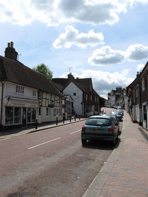
English: High Street Robertsbridge was a medieval development that grew around the Cistercian Priory and the subsequent bridge built by the monks over the nearby River Rother to cater for the Hastings-London road. The village was prosperous between the 14th-16th centuries judging by the number of Wealden Hall Houses built along the village street due to the travelling trade and as the site of both a local market and fair. The former continued into the 18th century being a popular stop for coaches and the street remained the busy A21 until 1992 when a new by-pass was built to the east of the village bringing peace to the main village street. Whilst a small village, Robertsbridge, is one of the larger settlements in one of the less populous areas of the Weald and has therefore retained a number of services with a number of shops, a bank, vets, three pubs and a couple of restaurants. |
| تاریخ | |
| قایناق | From geograph.org.uk |
| یازار | Simon Carey |
| موجَویز (required by the license) | Simon Carey / High Street / |
| مختصات دوربین | | محل قرارگیری این نگاره و سایر نگارهها در: نقشهٔ شهری باز |
|---|
_heading:180.00&language=azb)
| مختصات شیء | | محل قرارگیری این نگاره و سایر نگارهها در: نقشهٔ شهری باز |
|---|
_heading:180.00&language=azb)
لیسانس

|
این نگاره از مجموعهٔ پروژهٔ Geograph گرفته شدهاست. این صفحهٔ عکسها را در وبگاه Geograph برای جزئیات تماس با عکاس ببینید. حق تکثیر این تصویر به Simon Carey تعلق دارد و برای استفادهٔ مجدد تحت Creative Commons Attribution-ShareAlike 2.0 مجوزدهی شدهاست.
|
این پرونده با اجازهنامهٔ کریتیو کامانز Attribution-Share Alike 2.0 عمومی منتشر شدهاست.
موجَویز: Simon Carey
- سیزین ایجازه نیز وار دیر:
- بؤلۆشمک – اثرین کپی، پایلاشماق و چاتدیرماسی اوچون
- تلفیق ائت – اثرین توتوشدورماسی اوچون
- آشاغی داکی شرایطله:
- تخصیص – اثری مؤلف و یا لیسئنزییالی طرفیندن گؤستریلدیی کیمی ایستیناد ائتملیسینیز (آنجاق سنی دستکلدیینی و یا اثردن ایستیفاده ائتمیینیزی تکلیف ائتمملیسینیز).
- بیرگه پایلاشیم – اگر بو اثرده دَییشدیرمه، چؤندرمه، یا دا کؤکدن دوزلتمه ائتسز، اله گلمیش اثری یالنیز بیر ائشیت یوخسا اوخشار بیر مجوزین آلتیندا یاییملایابیلرسینیز .
فايل گئچمیشی
فايلین اولکی وئرسیياسینی گؤرمک اۆچون گۆن/تاریخ بؤلمهسیندهکی تاریخلری تێقلايین.
| تاریخ/واخت | کیچیک عکس | اؤلچولر | ایشلدن | باخیش | |
|---|---|---|---|---|---|
| ایندیکی | ۲۷ فوریه ۲۰۱۱، ساعت ۰۶:۱۷ | | ۴۸۰ در ۶۴۰ (۸۴ کیلوبایت) | GeographBot | == {{int:filedesc}} == {{Information |description={{en|1=High Street Robertsbridge was a medieval development that grew around the Cistercian Priory and the subsequent bridge built by the monks over the nearby River Rother to cater for the Hastings-London |
فايل ایشلدمهسی
آشاغیداکی صحیفه بو فایلا باغلانیر
فایلین باشاباش ایشلنیلمهسی
بو فایل آشاغی داکی آیری ویکی لرده ایشلَنیر:
- en.wikipedia.org-ده ایشلنمهسی
- fa.wikipedia.org-ده ایشلنمهسی