
فایل:Map of Israel, neighbours and occupied territories.svg

فایلین اصلی (SVG فایلی، ۵۵۹ × ۷۲۱ پیکسئل، فایلین اؤلچوسو: ۶۵۰ کیلوبایت)
قیساسی
| آچیقلاما |
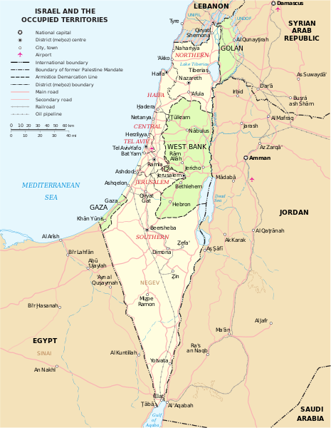
English: Map of the Middle East showing Israel, Egypt, Saudi Arabia, Jordan, Syria and Lebanon including Gaza, Golan Heights and West Bank.
العربية: خريطة دولة إسرائيل والأراضي الفلسطينية التي تشمل الضفة الغربية وقطاع غزة والجولان السوري المحتل. |
| تاریخ | |
| قایناق | SVG extracted and edited from PDF |
| یازار | un.org |
| آیری نوسخهلر | македонски |
| SVG genesis |
لیسانس
| This image is a map derived from a United Nations map.
Unless stated otherwise, UN maps are to be considered in the public domain. This applies worldwide. UN maps are, in principle, open source material and you can use them in your work or for making your own map. UN requests however that you delete the UN name, logo and reference number upon any modification to the map. Content of your map will be your responsibility. You can state in your publication, if you wish, something like: based on UN map … (map name, map number, revision number and date). See: Geospatial Information Section. And: Geospatial, location data for a better world. |
 |
| من، دارنده حق تکثیر این اثر، این اثر را به مالکیت عمومی منتشر میکنم. این قابل اجرا در تمام نقاط جهان است. در برخی از کشورها ممکن است به صورت قانونی این امکانپذیر نباشد؛ اگر چنین است: من اجازهٔ استفاده از این اثر را برای هر مقصودی، بدون هیچگونه شرایطی میدهم، تا وقتی که این شرایط توسط قانون مستلزم نشده باشد. |
فايل گئچمیشی
فايلین اولکی وئرسیياسینی گؤرمک اۆچون گۆن/تاریخ بؤلمهسیندهکی تاریخلری تێقلايین.
| تاریخ/واخت | کیچیک عکس | اؤلچولر | ایشلدن | باخیش | |
|---|---|---|---|---|---|
| ایندیکی | ۷ اوْکتوبر ۲۰۲۳، ساعت ۱۶:۰۷ | | ۵۵۹ در ۷۲۱ (۶۵۰ کیلوبایت) | LametinoWiki | File uploaded using svgtranslate tool (https://svgtranslate.toolforge.org/). Added translation for it. |
| ۷ اوْکتوبر ۲۰۲۳، ساعت ۱۶:۰۷ |  | ۵۵۹ در ۷۲۱ (۶۵۰ کیلوبایت) | LametinoWiki | File uploaded using svgtranslate tool (https://svgtranslate.toolforge.org/). Added translation for it. | |
| ۲۷ دسامبر ۲۰۲۲، ساعت ۰۱:۴۹ |  | ۵۵۹ در ۷۲۱ (۵۹۶ کیلوبایت) | Wikijahnn | File uploaded using svgtranslate tool (https://svgtranslate.toolforge.org/). Added translation for ca. | |
| ۲۷ دسامبر ۲۰۲۲، ساعت ۰۱:۴۶ |  | ۵۵۹ در ۷۲۱ (۵۹۶ کیلوبایت) | Wikijahnn | File uploaded using svgtranslate tool (https://svgtranslate.toolforge.org/). Added translation for ca. | |
| ۵ مئی ۲۰۱۸، ساعت ۱۷:۰۹ |  | ۵۵۹ در ۷۲۱ (۵۴۰ کیلوبایت) | FrankieF | Reverted to version as of 23:22, 5 March 2018 (UTC). Replaces a bad and blurred map without distance meter to a crisp and clear map. | |
| ۱۰ مارس ۲۰۱۸، ساعت ۱۸:۴۷ |  | ۵۵۹ در ۷۲۱ (۲۸۵ کیلوبایت) | Eric's son | The last version is outdated and factually incorrect. Reverted to version as of 21:50, 26 February 2018 (UTC) | |
| ۵ مارس ۲۰۱۸، ساعت ۲۳:۲۲ |  | ۵۵۹ در ۷۲۱ (۵۴۰ کیلوبایت) | Nableezy | Reverted to version as of 16:20, 12 December 2011 (UTC) make a different map, dont replace every other with this one | |
| ۲۶ فوریه ۲۰۱۸، ساعت ۲۱:۵۰ |  | ۵۵۹ در ۷۲۱ (۲۸۵ کیلوبایت) | Eric's son | small graphic fixes | |
| ۱۹ فوریه ۲۰۱۸، ساعت ۲۲:۲۴ |  | ۵۵۹ در ۷۲۱ (۲۵۹ کیلوبایت) | Eric's son | Adding relevant updates (evacuated UN zones), clear colored borders explained in legend. | |
| ۱۲ دسامبر ۲۰۱۱، ساعت ۱۶:۲۰ |  | ۵۵۹ در ۷۲۱ (۵۴۰ کیلوبایت) | Ch1902 | =={{int:filedesc}}== {{Information |Description={{en|1=Map of the Middle East showing Israel, Egypt, Saudi Arabia, Jordan, Syria and Lebanon including Gaza, Golan Heights and West Bank.}} |Source=SVG extracted and edited from [http://www.un.org/Depts/Car |
فايل ایشلدمهسی
آشاغیداکی صحیفه بو فایلا باغلانیر
فایلین باشاباش ایشلنیلمهسی
بو فایل آشاغی داکی آیری ویکی لرده ایشلَنیر:
- ary.wikipedia.org-ده ایشلنمهسی
- bxr.wikipedia.org-ده ایشلنمهسی
- ca.wikipedia.org-ده ایشلنمهسی
- da.wikipedia.org-ده ایشلنمهسی
- en.wikipedia.org-ده ایشلنمهسی
- ga.wikipedia.org-ده ایشلنمهسی
- gl.wikipedia.org-ده ایشلنمهسی
- hy.wikipedia.org-ده ایشلنمهسی
- it.wikipedia.org-ده ایشلنمهسی
- kn.wikipedia.org-ده ایشلنمهسی
- ko.wikipedia.org-ده ایشلنمهسی
- nl.wikipedia.org-ده ایشلنمهسی
- pap.wikipedia.org-ده ایشلنمهسی
- pnb.wikipedia.org-ده ایشلنمهسی
- ru.wikipedia.org-ده ایشلنمهسی
- sr.wikipedia.org-ده ایشلنمهسی
- sv.wikipedia.org-ده ایشلنمهسی
- www.wikidata.org-ده ایشلنمهسی