
فایل:Ohio Portage Kent.png

سیناق گؤستریشی اؤلچوسو: ۸۰۰ × ۴۶۸ پیکسل. آیری کیفیتلر: ۳۲۰ × ۱۸۷ پیکسل | ۶۴۰ × ۳۷۴ پیکسل | ۱٬۰۲۵ × ۵۹۹ پیکسل.
فایلین اصلی (۱٬۰۲۵ × ۵۹۹ پیکسل, فایل اؤلچوسو: ۱۴۱ کیلوبایت, MIME نوعو: image/png)
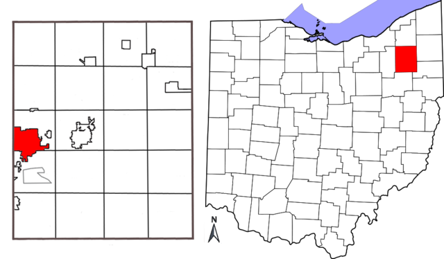
| آچیقلاما | Combination map showing location of Kent, Ohio within Portage County and Portage County's location within the state of Ohio. Original map of Ohio by David Benbennick; map of Portage County with Kent highlighted made by Jon Ridinger. |
| تاریخ | (UTC) |
| قایناق | |
| یازار |
| این یک عکس دستکاری شده است به این معنی که به صورت دیجیتالی از نسخهٔ اصلی تغییر یافتهاست. تغییرها: added two maps together; removed distance chart from Portage County map; moved compass. اصل آن را میتوان در اینجا مشاهده کرد: Portage County Kent.png. تغییرها توسط JonRidinger انجام شدهاست.
|
بو فایل کریتیو کامانز مجوز ایله Attribution-Share Alike 3.0 اویغونلاشمامیش یاییملانیبدیر.
- سیزین ایجازه نیز وار دیر:
- بؤلۆشمک – اثرین کپی، پایلاشماق و چاتدیرماسی اوچون
- تلفیق ائت – اثرین توتوشدورماسی اوچون
- آشاغی داکی شرایطله:
- تخصیص – اثری مؤلف و یا لیسئنزییالی طرفیندن گؤستریلدیی کیمی ایستیناد ائتملیسینیز (آنجاق سنی دستکلدیینی و یا اثردن ایستیفاده ائتمیینیزی تکلیف ائتمملیسینیز).
- بیرگه پایلاشیم – اگر بو اثرده دَییشدیرمه، چؤندرمه، یا دا کؤکدن دوزلتمه ائتسز، اله گلمیش اثری یالنیز بیر ائشیت یوخسا اوخشار بیر مجوزین آلتیندا یاییملایابیلرسینیز .
اورجینال یوکلمه گوندهلیگی
This image is a derivative work of the following images:
- File:Map_of_Ohio_highlighting_Portage_County.svg licensed with PD-self
- 2006-02-12T16:10:28Z David Benbennick 3675x3995 (59503 Bytes) {{subst:User:Dbenbenn/clm|county=Portage County|state=Ohio|type=county}}
- File:Portage_County_Kent.png licensed with Cc-by-3.0
- 2010-05-01T03:26:12Z JonRidinger 425x577 (81460 Bytes) Minor correction
- 2010-05-01T03:22:22Z JonRidinger 425x577 (76288 Bytes) Straightened map, cropped, removed extra white areas
- 2008-05-16T02:27:08Z JonRidinger 489x615 (44136 Bytes) {{Information |Description= Map of Portage County, Ohio with the city of Kent highlighted. |Source=self-made |Date= 15 May 2008 |Author= [[User:JonRidinger|JonRidinger]] |Permission= Public domain |other_versions= }} [[Categ
Uploaded with derivativeFX
فايل گئچمیشی
فايلین اولکی وئرسیياسینی گؤرمک اۆچون گۆن/تاریخ بؤلمهسیندهکی تاریخلری تێقلايین.
| تاریخ/واخت | کیچیک عکس | اؤلچولر | ایشلدن | باخیش | |
|---|---|---|---|---|---|
| ایندیکی | ۷ مئی ۲۰۱۰، ساعت ۱۲:۱۲ | | ۱٬۰۲۵ در ۵۹۹ (۱۴۱ کیلوبایت) | JonRidinger | {{Information |Description=Combination map showing location of Kent, Ohio within Portage County and Portage County's location within the state of Ohio. Original map of Ohio by [[User:Dbenbenn|David B |
فايل ایشلدمهسی
آشاغیداکی صحیفه بو فایلا باغلانیر
فایلین باشاباش ایشلنیلمهسی
بو فایل آشاغی داکی آیری ویکی لرده ایشلَنیر:
- ar.wikipedia.org-ده ایشلنمهسی
- arz.wikipedia.org-ده ایشلنمهسی
- bn.wikipedia.org-ده ایشلنمهسی
- ca.wikipedia.org-ده ایشلنمهسی
- ceb.wikipedia.org-ده ایشلنمهسی
- cy.wikipedia.org-ده ایشلنمهسی
- en.wikipedia.org-ده ایشلنمهسی
- eu.wikipedia.org-ده ایشلنمهسی
- fa.wikipedia.org-ده ایشلنمهسی
- fi.wikipedia.org-ده ایشلنمهسی
- fr.wikipedia.org-ده ایشلنمهسی
- ht.wikipedia.org-ده ایشلنمهسی
- id.wikipedia.org-ده ایشلنمهسی
- it.wikipedia.org-ده ایشلنمهسی
- no.wikipedia.org-ده ایشلنمهسی
- sh.wikipedia.org-ده ایشلنمهسی
- sr.wikipedia.org-ده ایشلنمهسی
- sv.wikipedia.org-ده ایشلنمهسی
- tr.wikipedia.org-ده ایشلنمهسی
- tt.wikipedia.org-ده ایشلنمهسی
- ur.wikipedia.org-ده ایشلنمهسی
- vo.wikipedia.org-ده ایشلنمهسی
- www.wikidata.org-ده ایشلنمهسی
- zh-min-nan.wikipedia.org-ده ایشلنمهسی
- zh.wikipedia.org-ده ایشلنمهسی