
فایل:Ojai, California (20960249094) (cropped).jpg

فایلین اصلی (۳٬۵۲۳ × ۱٬۸۷۰ پیکسل, فایل اؤلچوسو: ۲٫۱۵ مگابایت, MIME نوعو: image/jpeg)
قیساسی
| آچیقلاما |
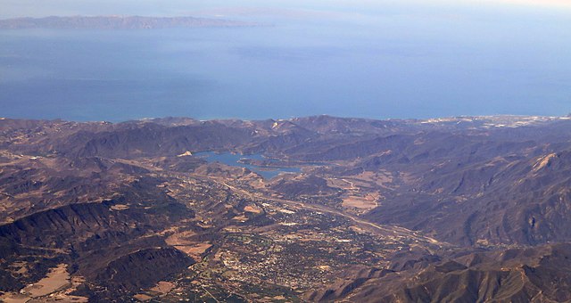
Ojai is a city in Ventura County, California, USA. It is situated in the Ojai Valley, approximately 10 miles long by 3 miles (4.8 km) wide or 16 kilometers by 5 kilometers, surrounded by hills and mountains. In 2003, the estimated population was 8,006, making it one of the smaller towns in the county. Chumash Indians were the early inhabitants of the valley. They called it Ojai, which means "Valley of the Moon." The area eventually became one of many Spanish/Mexican land grants along the California coast. In 1837, it was granted to Fernando Tico and he established a cattle rancho. Tico sold it in 1853 to prospectors searching for oil, without much success. By 1864, the area was settled. After fire destroyed much of the original western-style Nordhoff/Ojai in 1917, Libbey helped design, finance and build a new downtown more in line with the contemporary taste for Colonial-Revival architecture, including a Spanish-style arcade, a bell-tower reminiscent of the famous campanile in Havana, and a pergola opposite the arcade. These buildings still stand, and have come to serve as symbols of the city and the surrounding valley. Ojai is situated in a small east-west valley, north of Ventura and east of Santa Barbara. It is approximately 15 miles (24 km) inland from the Pacific coast. Since Ojai is lined up with an east-west mountain range, it is one of few towns in the world to have the Pink Moment occur as the sun is setting. The fading sunlight creates a brilliant shade of pink on the Topatopa Bluffs that stand at the east end of the Ojai Valley, reaching over 6,000 feet (1,800 m) above sea level. Nordhoff Ridge, the western extension of the Topatopa Mountains, towers over the north side of the town and valley at more than 5,000 feet (1,500 m). Sulphur Mountain creates the southern ranges bounding the Ojai Valley, a little under 3,000 feet (910 m) in elevation. The Ventura River flows through the Ventura River Valley, draining the mountains surrounding Ojai to the north and east and emptying into the Pacific Ocean at the city of Ventura. The climate of Ojai is Mediterranean, characterized by hot, dry summers (sometimes exceeding 100°F) and mild winters, with lows at night sometimes below freezing. As is typical for much of coastal southern California, most precipitation falls in the form of rain between the months of October and April, with intervening dry summers. The town of Ojai and its surrounding area is home to many unique recreational activities. Los Padres National Forest borders the town on the north, and many backcountry areas within the forest are accessible from Highway 33, which is the major highway through town south to north. en.wikipedia.org/wiki/Ojai,_California en.wikipedia.org/wiki/Wikipedia:Text_of_Creative_Commons_... |
| تاریخ | |
| قایناق | Ojai, California |
| یازار | Ken Lund from Reno, Nevada, USA |
| آیری نوسخهلر |
.jpg)
_(cropped).jpg)
| مختصات دوربین | | محل قرارگیری این نگاره و سایر نگارهها در: نقشهٔ شهری باز |
|---|
_(cropped).jpg¶ms=034.559144_N_-119.050317_E_globe:Earth_type:camera_source:Flickr_&language=azb)
لیسانس
- سیزین ایجازه نیز وار دیر:
- بؤلۆشمک – اثرین کپی، پایلاشماق و چاتدیرماسی اوچون
- تلفیق ائت – اثرین توتوشدورماسی اوچون
- آشاغی داکی شرایطله:
- تخصیص – اثری مؤلف و یا لیسئنزییالی طرفیندن گؤستریلدیی کیمی ایستیناد ائتملیسینیز (آنجاق سنی دستکلدیینی و یا اثردن ایستیفاده ائتمیینیزی تکلیف ائتمملیسینیز).
- بیرگه پایلاشیم – اگر بو اثرده دَییشدیرمه، چؤندرمه، یا دا کؤکدن دوزلتمه ائتسز، اله گلمیش اثری یالنیز بیر ائشیت یوخسا اوخشار بیر مجوزین آلتیندا یاییملایابیلرسینیز .
فايل گئچمیشی
فايلین اولکی وئرسیياسینی گؤرمک اۆچون گۆن/تاریخ بؤلمهسیندهکی تاریخلری تێقلايین.
| تاریخ/واخت | کیچیک عکس | اؤلچولر | ایشلدن | باخیش | |
|---|---|---|---|---|---|
| ایندیکی | ۲۶ نوْوامبر ۲۰۱۸، ساعت ۲۱:۵۲ | | ۳٬۵۲۳ در ۱٬۸۷۰ (۲٫۱۵ مگابایت) | Cristiano Tomás | Cropped 16 % vertically using CropTool with precise mode. |
| ۲۶ نوْوامبر ۲۰۱۸، ساعت ۲۱:۴۹ |  | ۳٬۵۲۳ در ۲٬۲۳۰ (۲٫۷۱ مگابایت) | Cristiano Tomás | File:Ojai, California (20960249094).jpg cropped 12 % horizontally, 26 % vertically using CropTool with precise mode. |
.jpg)
فايل ایشلدمهسی
آشاغیداکی صحیفه بو فایلا باغلانیر
فایلین باشاباش ایشلنیلمهسی
بو فایل آشاغی داکی آیری ویکی لرده ایشلَنیر:
- en.wikipedia.org-ده ایشلنمهسی
- mn.wikipedia.org-ده ایشلنمهسی
- nv.wikipedia.org-ده ایشلنمهسی
- pl.wikipedia.org-ده ایشلنمهسی
- simple.wikipedia.org-ده ایشلنمهسی
- sw.wikipedia.org-ده ایشلنمهسی
- uk.wikipedia.org-ده ایشلنمهسی
- ur.wikipedia.org-ده ایشلنمهسی
- zh.wikipedia.org-ده ایشلنمهسی
_(cropped).jpg)