
فایل:Partition of Hungary.png
یوخاری کیفیت الده یوخدور.
Partition_of_Hungary.png (۳۸۹ × ۳۲۸ پیکسل, فایل اؤلچوسو: ۳۱ کیلوبایت, MIME نوعو: image/png)
قیساسی

| آچیقلاما |
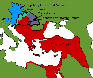
A map displaying position of the Kingdom of Hungary before 1541, and the 3 parts into which it was divided after the occupation of Buda in 1541: Royal Hungary, Eastern Hungarian kingdom, and the part that was annexed by the Ottoman Empire. en:Category:Maps of the history of Hungary |
| تاریخ | ۳ سپتامبر ۲۰۰۶ (تاریخ اصلی بارگذاری) |
| قایناق | Transferred from en.wikipedia to Commons. |
| یازار | Later versions were uploaded by PANONIAN, DonatusHR at en.wikipedia. |
لیسانس
| این اثر توسط پدیدآور آن، Esoltas در ویکیپدیا انگلیسی، به مالکیت عمومی درآمده است. این مربوط به تمام جهان است. در برخی از کشورها ممکن است به صورت قانونی این امکانپذیر نباشد؛ اگر چنین است: Esoltas به هر کسی اجازهٔ استفاده از این اثر برای هر مقصودی، بدون هیچگونه شرایطی، را میدهد تا وقتی که این شرایط توسط قانون مستلزم نشده باشند. |
اورجینال یوکلمه گوندهلیگی
The original description page was here. All following user names refer to en.wikipedia.
- 2007-08-12 15:14 DonatusHR 389×328×8 (38357 bytes) Vraćeno na prijašnju inačicu
- 2007-08-12 15:13 DonatusHR 389×328×8 (35596 bytes) Vraćeno na prijašnju inačicu
- 2006-10-11 10:58 PANONIAN 389×328×8 (38357 bytes) corrected image
- 2006-09-03 15:00 Esoltas 389×328×8 (35596 bytes) A map displaying the original position of the Kingdom of Hungary, and the 3 lands that became of it after the Battle of Mohács: Royal Hungary, Transylvania, and the Ottoman-occupied section.
فايل گئچمیشی
فايلین اولکی وئرسیياسینی گؤرمک اۆچون گۆن/تاریخ بؤلمهسیندهکی تاریخلری تێقلايین.
| تاریخ/واخت | کیچیک عکس | اؤلچولر | ایشلدن | باخیش | |
|---|---|---|---|---|---|
| ایندیکی | ۱۲ فوریه ۲۰۱۶، ساعت ۱۷:۲۲ | | ۳۸۹ در ۳۲۸ (۳۱ کیلوبایت) | Packare | better caption |
| ۱۰ سپتامبر ۲۰۰۷، ساعت ۱۷:۵۸ |  | ۳۸۹ در ۳۲۸ (۳۷ کیلوبایت) | Sir Iain | {{Information |Description=A map displaying position of the Kingdom of Hungary before 1526, and the 3 parts into which it was divided after the Battle of Mohács: Royal Hungary, Transylvania, and the part that was annexed by the Ottoman Empire. [[:en:Ca |
فايل ایشلدمهسی
آشاغیداکی صحیفه بو فایلا باغلانیر
فایلین باشاباش ایشلنیلمهسی
بو فایل آشاغی داکی آیری ویکی لرده ایشلَنیر:
- ar.wikipedia.org-ده ایشلنمهسی
- de.wikipedia.org-ده ایشلنمهسی
- el.wikipedia.org-ده ایشلنمهسی
- en.wikipedia.org-ده ایشلنمهسی
- es.wikipedia.org-ده ایشلنمهسی
- fr.wikipedia.org-ده ایشلنمهسی
- gl.wikipedia.org-ده ایشلنمهسی
- hu.wikipedia.org-ده ایشلنمهسی
- io.wikipedia.org-ده ایشلنمهسی
- it.wikipedia.org-ده ایشلنمهسی
- ja.wikipedia.org-ده ایشلنمهسی
- ko.wikipedia.org-ده ایشلنمهسی
- lv.wikipedia.org-ده ایشلنمهسی
- nl.wikipedia.org-ده ایشلنمهسی
- sk.wikipedia.org-ده ایشلنمهسی
- trv.wikipedia.org-ده ایشلنمهسی
- tr.wikipedia.org-ده ایشلنمهسی
- uk.wikipedia.org-ده ایشلنمهسی
- uz.wikipedia.org-ده ایشلنمهسی
- zh.wikipedia.org-ده ایشلنمهسی