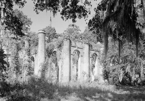
فایل:Prince William's Parish Church (Ruins), Sheldon vicinity (Beaufort County, South Carolina).jpg

Page contents not supported in other languages.
ویکی‌پدیادان، آچیق بیلیک‌لیک‌دن

Prince_William's_Parish_Church_(Ruins),_Sheldon_vicinity_(Beaufort_County,_South_Carolina).jpg(۵۸۸ × ۴۱۱ پیکسل, فایل اؤلچوسو: ۱۳۱ کیلوبایت, MIME نوعو: image/jpeg)

بو فایل ویکی‌انبار-دن‌دیر و آیری پروژه‌ده ایستیفاده اولماق امکانی وار. اونون باره‌سینده اولان شرح فایلین شرح صحیفه‌سی آشاغیدا گوستریلیب.

This is an image of a place or building that is listed on the National Register of Historic Places in the United States of America. Its reference number is 70000562.

آچیقلاما
English: Prince William's Parish Church (Ruins), Sheldon vicinity (Beaufort County, South Carolina) - (cropped)
This file comes from the Historic American Buildings Survey (HABS), Historic American Engineering Record (HAER) or Historic American Landscapes Survey (HALS). These are programs of the National Park Service established for the purpose of documenting historic places. Records consist of measured drawings, archival photographs, and written reports.

This tag does not indicate the copyright status of the attached work. A normal copyright tag is still required. See Commons:Licensing.

Public domain This image or media file contains material based on a work of a National Park Service employee, created as part of that person's official duties. As a work of the U.S. federal government, such work is in the public domain in the United States. See the NPS website and NPS copyright policy for more information.
مختصات شیء۳۲° ۳۷′ ۰۶٫۷″ N, ۸۰° ۴۶′ ۴۹٫۷″ W Kartographer map based on OpenStreetMap.محل قرارگیری این نگاره و سایر نگاره‌ها در: نقشهٔ شهری بازinfo
تاریخ
قایناق http://memory.loc.gov/cgi-bin/displayPhoto.pl?path=/pnp/habshaer/sc/sc0200/sc0277/photos&topImages=151946pr.jpg&topLinks=151946pv.jpg,151946pu.tif&title=HABS%20SC,7-SHELD,1-1&displayProfile=0
یازار نامعلومUnknown author
ایجازه
(فایلین تکرار ایستیفاده‌سی)
This file comes from the Historic American Buildings Survey (HABS), Historic American Engineering Record (HAER) or Historic American Landscapes Survey (HALS). These are programs of the National Park Service established for the purpose of documenting historic places. Records consist of measured drawings, archival photographs, and written reports.


When reusing please credit: Library of Congress, Prints & Photographs Division, SC,7-SHELD,1-1
This tag does not indicate the copyright status of the attached work. A normal copyright tag is still required. See Commons:Licensing.

Public domain This image or media file contains material based on a work of a National Park Service employee, created as part of that person's official duties. As a work of the U.S. federal government, such work is in the public domain in the United States. See the NPS website and NPS copyright policy for more information.

عنوان

شرحی یک‌خطی از محتوای این فایل اضافه کنید

آیتم‌هایی که در این پرونده نمایش داده شده‌اند

توصیف‌ها فارسی

ویرانه فارسی

32°37'6.701"N, 80°46'49.699"W

فايل گئچمیشی

فايلین اول‌کی وئرسیياسینی گؤرمک اۆچون گۆن/تاریخ بؤلمه‌سینده‌کی تاریخلری تێقلايین.

تاریخ/واختکیچیک عکساؤلچولرایشلدنباخیش
ایندیکی‏۴ جولای ۲۰۰۸، ساعت ۱۹:۲۷‏۴ جولای ۲۰۰۸، ساعت ۱۹:۲۷ تاریخینده‌کی سۆروموندن کیچیک گؤرونتوسو۵۸۸ در ۴۱۱ (۱۳۱ کیلوبایت)KudzuVine{{Information |Description={{en|1=Prince William's Parish Church (Ruins), Sheldon vicinity (Beaufort County, South Carolina) - (cropped) {{PD-USGov-Interior-HABS}}}} |Source=http://memory.loc.gov/cgi-bin/displayPhoto.pl?path=/pnp/habshaer/sc/sc0200/sc0277

آشاغیداکی صحیفه بو فایلا باغلانیر

فایلین باشاباش ایشلنیلمه‌سی

بو فایل آشاغی داکی آیری ویکی لرده ایشلَنیر:

مِتابیلگی‌لر