
فایل:Saxony locator map (1000).svg

حجم پیشنمایش PNG این SVG file:۶۸۶ × ۶۰۰ پیکسل آیری کیفیتلر: ۲۷۵ × ۲۴۰ پیکسل | ۵۴۹ × ۴۸۰ پیکسل | ۸۷۸ × ۷۶۸ پیکسل | ۱٬۱۷۱ × ۱٬۰۲۴ پیکسل | ۲٬۳۴۲ × ۲٬۰۴۸ پیکسل | ۴٬۴۳۱ × ۳٬۸۷۵ پیکسل.
فایلین اصلی (SVG فایلی، ۴٬۴۳۱ × ۳٬۸۷۵ پیکسئل، فایلین اؤلچوسو: ۴٫۷ مگابایت)
قیساسی
| آچیقلاما |
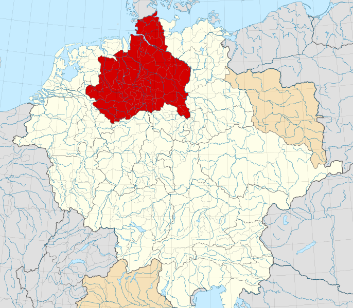
English: A map of the Duchy of Saxony (German: Herzogtum Sachsen) around 1000 CE.
The map is derived from a vectorised version of one found in Professor G. Droysens Allgemeiner Historischer Handatlas, which was published in 1886 by R. Andrée Plate, and is now in the public domain. Note that while it uses the same scheme as standard location/locator maps, this map technically does not conform to the standard, as it is not in equirectangular projection. Therefore grid lines for latitude and longitude are also included on the sub-map. |
| تاریخ | |
| قایناق |
File: own work Data: File:Droysens-22-23.jpg |
| یازار | Alphathon /ˈæɫfə.θɒn/ (talk) |
| آیری نوسخهلر |
|
.svg)
.svg)
.svg)
.svg)

.svg)
.svg)
.svg)
لیسانس
این پرونده تحت پروانهٔ Creative Commons Attribution-Share Alike 4.0 International منتشر شده است.
- سیزین ایجازه نیز وار دیر:
- بؤلۆشمک – اثرین کپی، پایلاشماق و چاتدیرماسی اوچون
- تلفیق ائت – اثرین توتوشدورماسی اوچون
- آشاغی داکی شرایطله:
- تخصیص – اثری مؤلف و یا لیسئنزییالی طرفیندن گؤستریلدیی کیمی ایستیناد ائتملیسینیز (آنجاق سنی دستکلدیینی و یا اثردن ایستیفاده ائتمیینیزی تکلیف ائتمملیسینیز).
- بیرگه پایلاشیم – اگر بو اثرده دَییشدیرمه، چؤندرمه، یا دا کؤکدن دوزلتمه ائتسز، اله گلمیش اثری یالنیز بیر ائشیت یوخسا اوخشار بیر مجوزین آلتیندا یاییملایابیلرسینیز .
فايل گئچمیشی
فايلین اولکی وئرسیياسینی گؤرمک اۆچون گۆن/تاریخ بؤلمهسیندهکی تاریخلری تێقلايین.
| تاریخ/واخت | کیچیک عکس | اؤلچولر | ایشلدن | باخیش | |
|---|---|---|---|---|---|
| ایندیکی | ۲۲ مئی ۲۰۱۶، ساعت ۱۶:۱۵ | | ۴٬۴۳۱ در ۳٬۸۷۵ (۴٫۷ مگابایت) | Alphathon | Changed colour of the Kingdom of Italy to reflect its inclusion in the Holy Roman Empire. Changed the colour of Silesian tributaries so as the not imply it was part of the Kingdom. Also changed colour of Rügen since it was neither in the Empire nor th... |
| ۱۸ مئی ۲۰۱۶، ساعت ۰۲:۲۶ |  | ۴٬۴۳۱ در ۳٬۸۷۵ (۴٫۷ مگابایت) | Alphathon | == {{int:filedesc}} == {{Inkscape}} {{Information |Description={{en|A map of the en:Duchy of Saxony (German: ''Herzogtum Sachsen'') around 1000 CE. The map is derived from a vectorised version of one found in Professor G. Droysens Allgem... |
فايل ایشلدمهسی
آشاغیداکی صحیفه بو فایلا باغلانیر
فایلین باشاباش ایشلنیلمهسی
بو فایل آشاغی داکی آیری ویکی لرده ایشلَنیر:
- ar.wikipedia.org-ده ایشلنمهسی
- ast.wikipedia.org-ده ایشلنمهسی
- be.wikipedia.org-ده ایشلنمهسی
- bg.wikipedia.org-ده ایشلنمهسی
- ca.wikipedia.org-ده ایشلنمهسی
- cs.wikipedia.org-ده ایشلنمهسی
- de.wikipedia.org-ده ایشلنمهسی
- el.wikipedia.org-ده ایشلنمهسی
- en.wikipedia.org-ده ایشلنمهسی
- es.wikipedia.org-ده ایشلنمهسی
- et.wikipedia.org-ده ایشلنمهسی
- fa.wikipedia.org-ده ایشلنمهسی
- fr.wikipedia.org-ده ایشلنمهسی
- fy.wikipedia.org-ده ایشلنمهسی
- ga.wikipedia.org-ده ایشلنمهسی
- it.wikipedia.org-ده ایشلنمهسی
- ja.wikipedia.org-ده ایشلنمهسی
- ko.wikipedia.org-ده ایشلنمهسی
- mk.wikipedia.org-ده ایشلنمهسی
- pl.wikipedia.org-ده ایشلنمهسی
- pl.wiktionary.org-ده ایشلنمهسی
- th.wikipedia.org-ده ایشلنمهسی
- tr.wikipedia.org-ده ایشلنمهسی
- vi.wikipedia.org-ده ایشلنمهسی
- www.wikidata.org-ده ایشلنمهسی
- zh.wikipedia.org-ده ایشلنمهسی
.svg)