
فایل:Trafalgar 1200hr.gif
سیناق گؤستریشی اؤلچوسو: ۶۳۵ × ۶۰۰ پیکسل. آیری کیفیتلر: ۲۵۴ × ۲۴۰ پیکسل | ۵۰۸ × ۴۸۰ پیکسل | ۹۰۰ × ۸۵۰ پیکسل.
فایلین اصلی (۹۰۰ × ۸۵۰ پیکسل, فایل اؤلچوسو: ۳۰ کیلوبایت, MIME نوعو: image/gif)

|
این پرونده توسط File:Trafalgar 1200hr.svg جایگزین شدهاست. توصیه میشود که پروندهٔ دیگر را استفاده کنید. توجه داشته باشید که پاک کردن نگارههای جایگرین شده به رضایت نیاز دارد. دلیل استفاده از پروندهٔ دیگر: "The new file is SVG, and has less spelling mistakes"
|

|
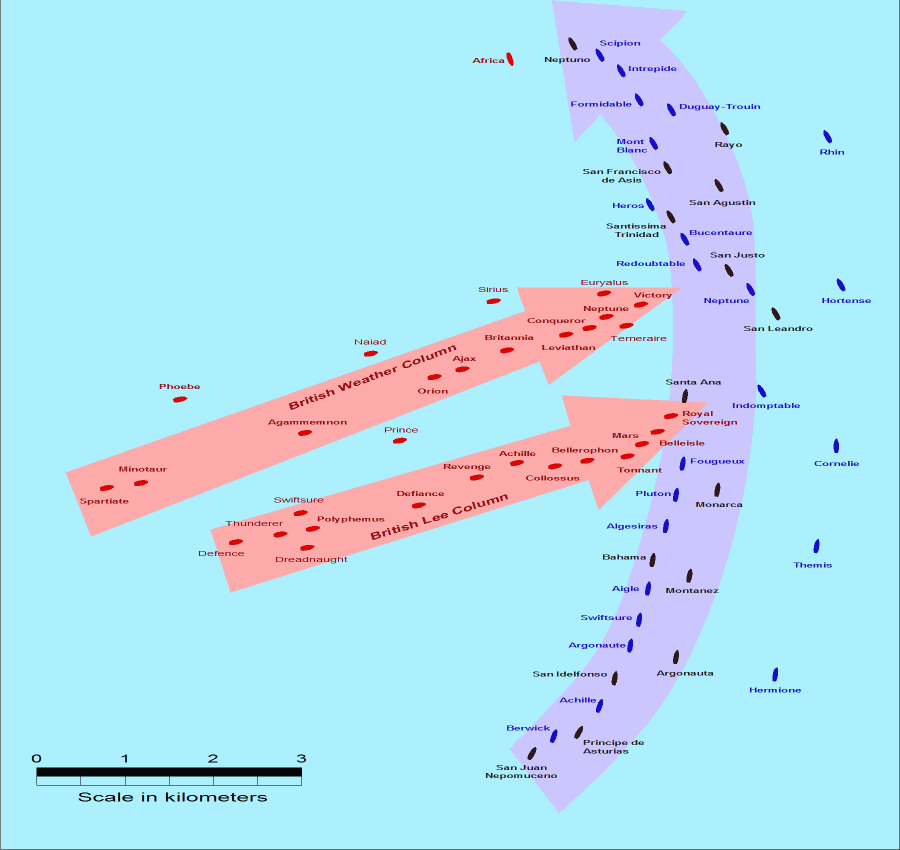
- Description: This map of the Battle of Trafalgar shows the approximate position of the two fleets at 1200 hours during the battle as the Royal Sovereign was breaking into the Franco-Spanish line. North is to the top, and Cape Trafalgar is 10 miles to the northeast.
- Size: 900 × 850 pixels.
- Source: This drawing is based on an illustration in issue number 84 of the Strategy & Tactics magazine The map was made by RJHall using the Campaign Cartographer drawing program, and the image was reduced in size 50% in Paint Shop Pro. Ship icons are not to scale.
این پرونده با اجازهنامهٔ کریتیو کامانز Attribution-Share Alike 2.5 عمومی منتشر شده است.
- سیزین ایجازه نیز وار دیر:
- بؤلۆشمک – اثرین کپی، پایلاشماق و چاتدیرماسی اوچون
- تلفیق ائت – اثرین توتوشدورماسی اوچون
- آشاغی داکی شرایطله:
- تخصیص – اثری مؤلف و یا لیسئنزییالی طرفیندن گؤستریلدیی کیمی ایستیناد ائتملیسینیز (آنجاق سنی دستکلدیینی و یا اثردن ایستیفاده ائتمیینیزی تکلیف ائتمملیسینیز).
- بیرگه پایلاشیم – اگر بو اثرده دَییشدیرمه، چؤندرمه، یا دا کؤکدن دوزلتمه ائتسز، اله گلمیش اثری یالنیز بیر ائشیت یوخسا اوخشار بیر مجوزین آلتیندا یاییملایابیلرسینیز .
فايل گئچمیشی
فايلین اولکی وئرسیياسینی گؤرمک اۆچون گۆن/تاریخ بؤلمهسیندهکی تاریخلری تێقلايین.
| تاریخ/واخت | کیچیک عکس | اؤلچولر | ایشلدن | باخیش | |
|---|---|---|---|---|---|
| ایندیکی | ۲۸ جولای ۲۰۰۵، ساعت ۱۴:۳۰ | | ۹۰۰ در ۸۵۰ (۳۰ کیلوبایت) | RJHall | Battle of Trafalgar situation at 1200hr, 21 October 1805. |
فايل ایشلدمهسی
بو فایلا هئچ بیر صفحهیه باغلانماییب.
فایلین باشاباش ایشلنیلمهسی
بو فایل آشاغی داکی آیری ویکی لرده ایشلَنیر:
- fr.wikipedia.org-ده ایشلنمهسی
- ja.wikipedia.org-ده ایشلنمهسی