
فایل:USA Mass Cape Cod location map.svg

حجم پیشنمایش PNG این SVG file:۵۶۰ × ۴۲۰ پیکسل آیری کیفیتلر: ۳۲۰ × ۲۴۰ پیکسل | ۶۴۰ × ۴۸۰ پیکسل | ۱٬۰۲۴ × ۷۶۸ پیکسل | ۱٬۲۸۰ × ۹۶۰ پیکسل | ۲٬۵۶۰ × ۱٬۹۲۰ پیکسل.
فایلین اصلی (SVG فایلی، ۵۶۰ × ۴۲۰ پیکسئل، فایلین اؤلچوسو: ۲۶۴ کیلوبایت)
قیساسی
| آچیقلاما |
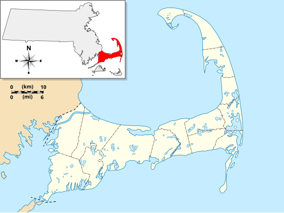
English: Location Map specific to (and zoomed to) Cape Cod, made specifically for the "WikiProject Massachusetts - Cape Cod and the Islands" on the English Wikipedia, but it is available to all.
For detailed instructions and several examples showing the various ways to use this file, see the documentation page at en:Module:Location map/data/USA Cape Cod. Specifications:
|
| تاریخ | |
| قایناق | یوکلهیهنین اؤز ایشی |
| یازار | Grolltech |
| آیری نوسخهلر |
این پرونده مشتق شدهاست از: USA Massachusetts location map.svg: |
| SVG genesis | کد مبدأ این پروندهٔ گرافیک برداری مقیاسپذیر، معتبر. این نقشهٔ جهان با Inkscape ساخته شده است, or with something else. |
لیسانس
من، صاحب حقوق قانونی این اثر، به این وسیله این اثر را تحث اجازهنامهٔ ذیل منتشر میکنم:
بو فایل کریتیو کامانز مجوز ایله Attribution-Share Alike 3.0 اویغونلاشمامیش یاییملانیبدیر.
- سیزین ایجازه نیز وار دیر:
- بؤلۆشمک – اثرین کپی، پایلاشماق و چاتدیرماسی اوچون
- تلفیق ائت – اثرین توتوشدورماسی اوچون
- آشاغی داکی شرایطله:
- تخصیص – اثری مؤلف و یا لیسئنزییالی طرفیندن گؤستریلدیی کیمی ایستیناد ائتملیسینیز (آنجاق سنی دستکلدیینی و یا اثردن ایستیفاده ائتمیینیزی تکلیف ائتمملیسینیز).
- بیرگه پایلاشیم – اگر بو اثرده دَییشدیرمه، چؤندرمه، یا دا کؤکدن دوزلتمه ائتسز، اله گلمیش اثری یالنیز بیر ائشیت یوخسا اوخشار بیر مجوزین آلتیندا یاییملایابیلرسینیز .
فايل گئچمیشی
فايلین اولکی وئرسیياسینی گؤرمک اۆچون گۆن/تاریخ بؤلمهسیندهکی تاریخلری تێقلايین.
| تاریخ/واخت | کیچیک عکس | اؤلچولر | ایشلدن | باخیش | |
|---|---|---|---|---|---|
| ایندیکی | ۱۳ مئی ۲۰۱۳، ساعت ۱۱:۲۵ | | ۵۶۰ در ۴۲۰ (۲۶۴ کیلوبایت) | Grolltech | reshaped Monomoy; added overlay layers to facilitate reuse of this file |
| ۷ مئی ۲۰۱۳، ساعت ۲۲:۴۵ |  | ۵۶۰ در ۴۲۰ (۱۸۹ کیلوبایت) | Grolltech | further reduced thickness of town boundaries, land outlines | |
| ۶ مئی ۲۰۱۳، ساعت ۰۸:۱۰ |  | ۵۶۰ در ۴۲۰ (۲۰۶ کیلوبایت) | Grolltech | moved compass rose out of the way | |
| ۳۱ مئی ۲۰۱۲، ساعت ۱۷:۳۹ |  | ۵۶۰ در ۴۲۰ (۲۰۵ کیلوبایت) | Grolltech | 1) moved scale legend to the left edge, and 2) reduced thickness of town boundaries, land outlines, lakes and ponds. Both of these changes are intended lessen the impact on readability of pushpin labels. | |
| ۱۳ مئی ۲۰۱۲، ساعت ۱۷:۲۱ |  | ۵۶۰ در ۴۲۰ (۲۰۶ کیلوبایت) | Grolltech | added town boundaries | |
| ۱۳ مئی ۲۰۱۲، ساعت ۰۵:۵۱ |  | ۵۶۰ در ۴۲۰ (۱۹۰ کیلوبایت) | Grolltech | {{Information |Description ={{en|1=Locator Map for Cape Cod exclusively. Made for "Wikiproject Massachusetts - Cape Cod and the Islands". Equirectangular projection, N/S stretching 130.0 %. Geographic limits of the map: Northern boundary: 42.104... |
فايل ایشلدمهسی
آشاغیداکی 4 صحیفهلر بو فایلا باغلانیرلار
فایلین باشاباش ایشلنیلمهسی
بو فایل آشاغی داکی آیری ویکی لرده ایشلَنیر:
- ar.wikipedia.org-ده ایشلنمهسی
- ceb.wikipedia.org-ده ایشلنمهسی
- en.wikipedia.org-ده ایشلنمهسی
- Cape Cod
- Cape Cod Canal
- Provincetown Harbor
- Cape Cod Baseball League
- Eastham Windmill
- Sagamore Beach, Massachusetts
- Attaquin Beach
- Provincetown Historic District
- Race Point Light
- Center Methodist Church
- Provincetown Public Library (old)
- North Truro Air Force Station
- South Harwich, Massachusetts
- Hyannis Armory
- Louis Brandeis House
- Nauset Archeological District
- Ancient Burying Ground
- Chatham Windmill
- First Universalist Church (Provincetown, Massachusetts)
- Adams-Crocker-Fish House
- South Harwich Methodist Church
- Osterville Baptist Church
- Old Higgins Farm Windmill
- Universalist Society Meetinghouse
- Poor House and Methodist Cemetery
- Cove Burying Ground
- Bridge Road Cemetery
- Old Indian Meeting House
- Ahearn House and Summer House
- Josiah A. Ames House
- Atwood–Higgins Historic District
- Barnstable County Courthouse
- Avant House (Mashpee, Massachusetts)
- Capt. Rodney J. Baxter House
- George I. Briggs House
- Benjamin Baker Jr. House
- Capt. Seth Baker Jr. House
- Nathaniel Baker House
- Baxter Mill
- Lemuel B. Chase House
- Canary-Hartnett House
- Brewster Old King's Highway Historic District
- Thomas Bray Farm
- Capt. Sylvester Baxter House
- Shubael Baxter House
- Sea Call Farm
- Congregation Beth Israel (Onset, Massachusetts)
بو فایلینسراسری ایستفاده لرینه باخین.