
فایل:WW2-Holocaust-Poland.PNG
فایلین اصلی (۲٬۰۰۷ × ۲٬۱۶۱ پیکسل, فایل اؤلچوسو: ۱٫۳۴ مگابایت, MIME نوعو: image/png)

|
این map نگاره میبایست با استفاده از گرافیک برداری اسویجی فایل بازسازی شوند. این چند مزیت دارد؛ Commons:Media for cleanup را برای اطلاعات بیشتر ببینید. اگر حالت برداری آن در حال حاضر موجود است، لطفاً آن را بار کنید. پس از بارکردن یک اسویجی، این الگو را با {{vector version available|new image name.svg}} جایگزین کنید.
|
قیساسی
| آچیقلاما |
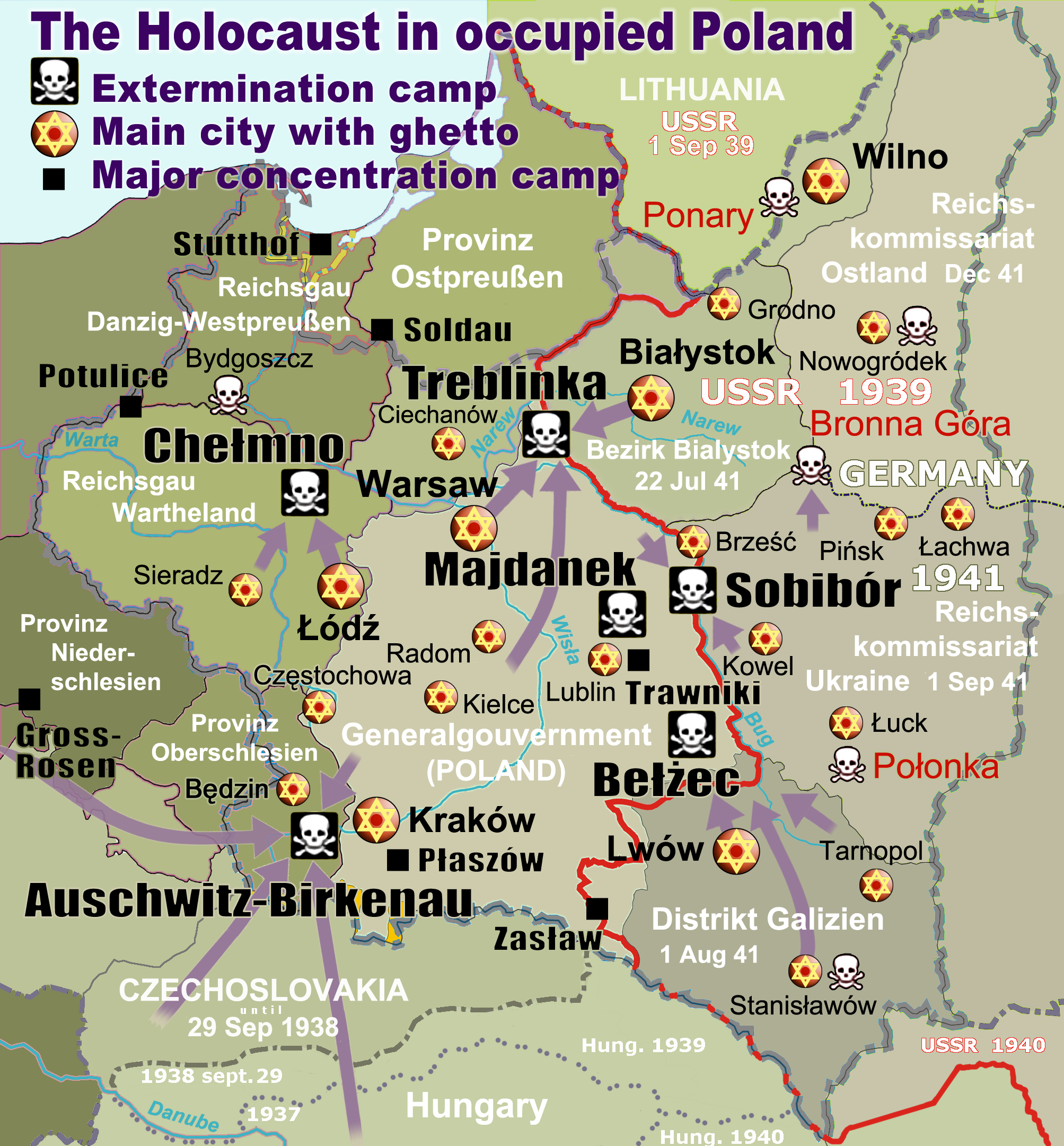
English: Map of the Holocaust in occupied Poland during World War II. The outline shows the borders of the Second Polish Republic at the time of the Nazi-German-and-Soviet invasion of Poland in 1939 with demarcation line between the two invading armies marked in red. Internal boundaries show the administrative divisions of occupied territories imposed by Nazi Germany when the Final Solution was set in motion during and after Operation Barbarossa of 1941. This map shows all Nazi German extermination camps (or death camps), as well as prominent concentration, labour and prison camps, major pre-WW2 Polish cities with the new Jewish ghettos set up by Nazi Germany, major deportation routes, and major massacre sites. Notes: 1. Extermination camps – marked with white skulls in black squares – are six dedicated facilities used for the mass gassings of prisoners, but all camps and ghettos took a toll of many, many lives. 2. Concentration camps – marked with black squares – feature only the most notorious forced-labor camps, prison camps & transit camps. 3. Sites of mass shootings into remote ravines – marked with white skulls – include Bronna Góra, Ponary and others. They were utilized during the 'Holocaust by bullets'. 4. Destruction ghettos – marked with Yellow stars in red circles – existed in most Polish cities. Only a selection is shown. 5. Major deportation routes travelled by the Holocaust trains are marked with RosyBrown arrows. 6. Most camps & ghettos which are not well known have been excluded for clarity. 7. District borders are at the height of Axis domination (1942). 8. Regions have German designations (e.g. "Ostland"), with the country name denoted in uppercase letters, e.g. LITHUANIA, CZECHOSLOVAKIA, or in parenthesis below the German occupational designation, e.g. (POLAND). |
| تاریخ | |
| قایناق |
یوکلهیهنین اؤز ایشی. Composite map derived from a variety of readily available sources which may or may not include:
|
| یازار |
|
| ایجازه (فایلین تکرار ایستیفادهسی) |
PD, see below. The map is completely unrestricted for any Wikipedia/Wikimedia project. |
| آیری نوسخهلر |
[]
|


.png)


.png)


لیسانس
For all derivative works of maps uploaded earlier see below.
| من، دارنده حق تکثیر این اثر، این اثر را به مالکیت عمومی منتشر میکنم. این قابل اجرا در تمام نقاط جهان است. در برخی از کشورها ممکن است به صورت قانونی این امکانپذیر نباشد؛ اگر چنین است: من اجازهٔ استفاده از این اثر را برای هر مقصودی، بدون هیچگونه شرایطی میدهم، تا وقتی که این شرایط توسط قانون مستلزم نشده باشد. |
- File uploaded previously
- سیزین ایجازه نیز وار دیر:
- بؤلۆشمک – اثرین کپی، پایلاشماق و چاتدیرماسی اوچون
- تلفیق ائت – اثرین توتوشدورماسی اوچون
- آشاغی داکی شرایطله:
- تخصیص – اثری مؤلف و یا لیسئنزییالی طرفیندن گؤستریلدیی کیمی ایستیناد ائتملیسینیز (آنجاق سنی دستکلدیینی و یا اثردن ایستیفاده ائتمیینیزی تکلیف ائتمملیسینیز).
Derivative work: Piotr Konieczny aka Prokonsul Piotrus Talk Derivative works of this file:
Derivative work: User:Poeticbent (Talk) Derivative works of this file:
- Uploaded previously
| این یک عکس دستکاری شده است به این معنی که به صورت دیجیتالی از نسخهٔ اصلی تغییر یافتهاست. تغییرها: Smaller version: occupied Poland only (pre-WWII borders). اصل آن را میتوان در اینجا مشاهده کرد: WW2-Holocaust-Europe.png.
|
- سیزین ایجازه نیز وار دیر:
- بؤلۆشمک – اثرین کپی، پایلاشماق و چاتدیرماسی اوچون
- تلفیق ائت – اثرین توتوشدورماسی اوچون
- آشاغی داکی شرایطله:
- تخصیص – اثری مؤلف و یا لیسئنزییالی طرفیندن گؤستریلدیی کیمی ایستیناد ائتملیسینیز (آنجاق سنی دستکلدیینی و یا اثردن ایستیفاده ائتمیینیزی تکلیف ائتمملیسینیز).
اورجینال یوکلمه گوندهلیگی
For derivative works of the first uploaded file created by User:Dna-webmaster see the following:
- File:WW2-Holocaust-Europe.png licensed with Cc-by-3.0
Uploaded with derivativeFX
فايل گئچمیشی
فايلین اولکی وئرسیياسینی گؤرمک اۆچون گۆن/تاریخ بؤلمهسیندهکی تاریخلری تێقلايین.
| تاریخ/واخت | کیچیک عکس | اؤلچولر | ایشلدن | باخیش | |
|---|---|---|---|---|---|
| ایندیکی | ۱۰ مارس ۲۰۲۰، ساعت ۱۵:۴۶ | | ۲٬۰۰۷ در ۲٬۱۶۱ (۱٫۳۴ مگابایت) | Claude Zygiel | Cosmetics |
| ۲۸ مارس ۲۰۱۸، ساعت ۲۰:۳۳ |  | ۲٬۰۰۷ در ۲٬۱۶۱ (۱٫۴۸ مگابایت) | Poeticbent | not an improvement: img looks muddy but I have original Photoshop layers, and can adjust them individually; comment on specifics in talk please | |
| ۲۷ مارس ۲۰۱۸، ساعت ۱۷:۴۸ |  | ۲٬۰۰۷ در ۲٬۱۶۱ (۱٫۴۹ مگابایت) | Hohum | Too much information competing for attention in a very busy image. Toned down region name brightness, desaturated slightly. | |
| ۱۰ جولای ۲۰۱۷، ساعت ۰۵:۳۸ |  | ۲٬۰۰۷ در ۲٬۱۶۱ (۱٫۴۸ مگابایت) | Poeticbent | vital updates following a discussion → prominent ghettos, legend | |
| ۲۵ جولای ۲۰۱۵، ساعت ۱۹:۴۳ |  | ۲٬۰۰۷ در ۲٬۱۶۱ (۱٫۴۶ مگابایت) | Poeticbent | name of settlement: Górka Połonka, source Wolyn.ovh.org | |
| ۲ دسامبر ۲۰۱۴، ساعت ۱۸:۲۷ |  | ۲٬۰۰۷ در ۲٬۱۶۱ (۱٫۴۶ مگابایت) | Poeticbent | added one missing marker | |
| ۷ مئی ۲۰۱۴، ساعت ۱۹:۱۷ |  | ۲٬۰۰۷ در ۲٬۱۶۱ (۱٫۴۵ مگابایت) | Poeticbent | location of Bronna Góra | |
| ۴ آوریل ۲۰۱۴، ساعت ۱۷:۳۴ |  | ۲٬۰۰۷ در ۲٬۱۶۱ (۱٫۴۴ مگابایت) | Poeticbent | Lachwa Ghetto location | |
| ۲۷ ژوئن ۲۰۱۳، ساعت ۲۱:۳۱ |  | ۲٬۰۰۷ در ۲٬۱۶۱ (۱٫۴۲ مگابایت) | Poeticbent | major expansion with similar color-scheme | |
| ۲۸ ژوئن ۲۰۱۱، ساعت ۰۳:۰۹ |  | ۳۶۴ در ۳۳۹ (۱۲۳ کیلوبایت) | LMK3 | changed the color of the Soviet Curzon line to indicate the two different occupation zones before Operation Barbarossa, refined the location of Warsaw |
فايل ایشلدمهسی
آشاغیداکی صحیفه بو فایلا باغلانیر
فایلین باشاباش ایشلنیلمهسی
بو فایل آشاغی داکی آیری ویکی لرده ایشلَنیر:
- ar.wikipedia.org-ده ایشلنمهسی
- az.wikipedia.org-ده ایشلنمهسی
- bg.wikipedia.org-ده ایشلنمهسی
- bn.wikipedia.org-ده ایشلنمهسی
- br.wikipedia.org-ده ایشلنمهسی
- ca.wikipedia.org-ده ایشلنمهسی
- cs.wikipedia.org-ده ایشلنمهسی
- cs.wikibooks.org-ده ایشلنمهسی
- da.wikipedia.org-ده ایشلنمهسی
- de.wikipedia.org-ده ایشلنمهسی
- el.wikipedia.org-ده ایشلنمهسی
- Γκέτο της Τσενστοχόβα
- Γκέτο του Μπέντζιν
- Γκέτο του Μίζοτς
- Μπρόνα Γκούρα
- Γκέτο της Κρακοβίας
- Γκέτο του Μπζέσκο
- Στρατόπεδο συγκέντρωσης Τραβνίκι
- Στρατόπεδο συγκέντρωσης Ποτουλίτσε
- Γκέτο του Σοσνόβιετς
- Γκέτο του Ντροχόμπιτς
- Γκέτο του Ταρνόπολ
- Ιστορία των Εβραίων στην Πολωνία
- Γκέτο του Σιέντλτσε
- Γκέτο της Γουόμζα
- Γκέτο του Γκορλίτσε
- Γκέτο του Μπιαουίστοκ
- Γκέτο του Μπζεστς
- Γκέτο του Ράντομ
- Γκέτο του Νόβι Σοντς
- en.wikipedia.org-ده ایشلنمهسی
بو فایلینسراسری ایستفاده لرینه باخین.