
فایل:1753 Vaugondy Map of Persia, Arabia and Turkey - Geographicus - TurkeyArabiaPersia-vaugondy-1753.jpg
سیناق گؤستریشی اؤلچوسو: ۶۹۸ × ۵۹۹ پیکسل. آیری کیفیتلر: ۲۸۰ × ۲۴۰ پیکسل | ۵۵۹ × ۴۸۰ پیکسل | ۸۹۵ × ۷۶۸ پیکسل | ۱٬۱۹۳ × ۱٬۰۲۴ پیکسل | ۲٬۳۸۵ × ۲٬۰۴۸ پیکسل | ۵٬۰۰۰ × ۴٬۲۹۳ پیکسل.
فایلین اصلی (۵٬۰۰۰ × ۴٬۲۹۳ پیکسل, فایل اؤلچوسو: ۶٫۹ مگابایت, MIME نوعو: image/jpeg)
| Etats du Grand-Seigneur en Asie, Empire de Perse, Pays des Usbecs, Arabie et Egypte. | ||||||
|---|---|---|---|---|---|---|
| آرتیست | ||||||
| باشلیق |
Etats du Grand-Seigneur en Asie, Empire de Perse, Pays des Usbecs, Arabie et Egypte. |
|||||
| آچیقلاما |
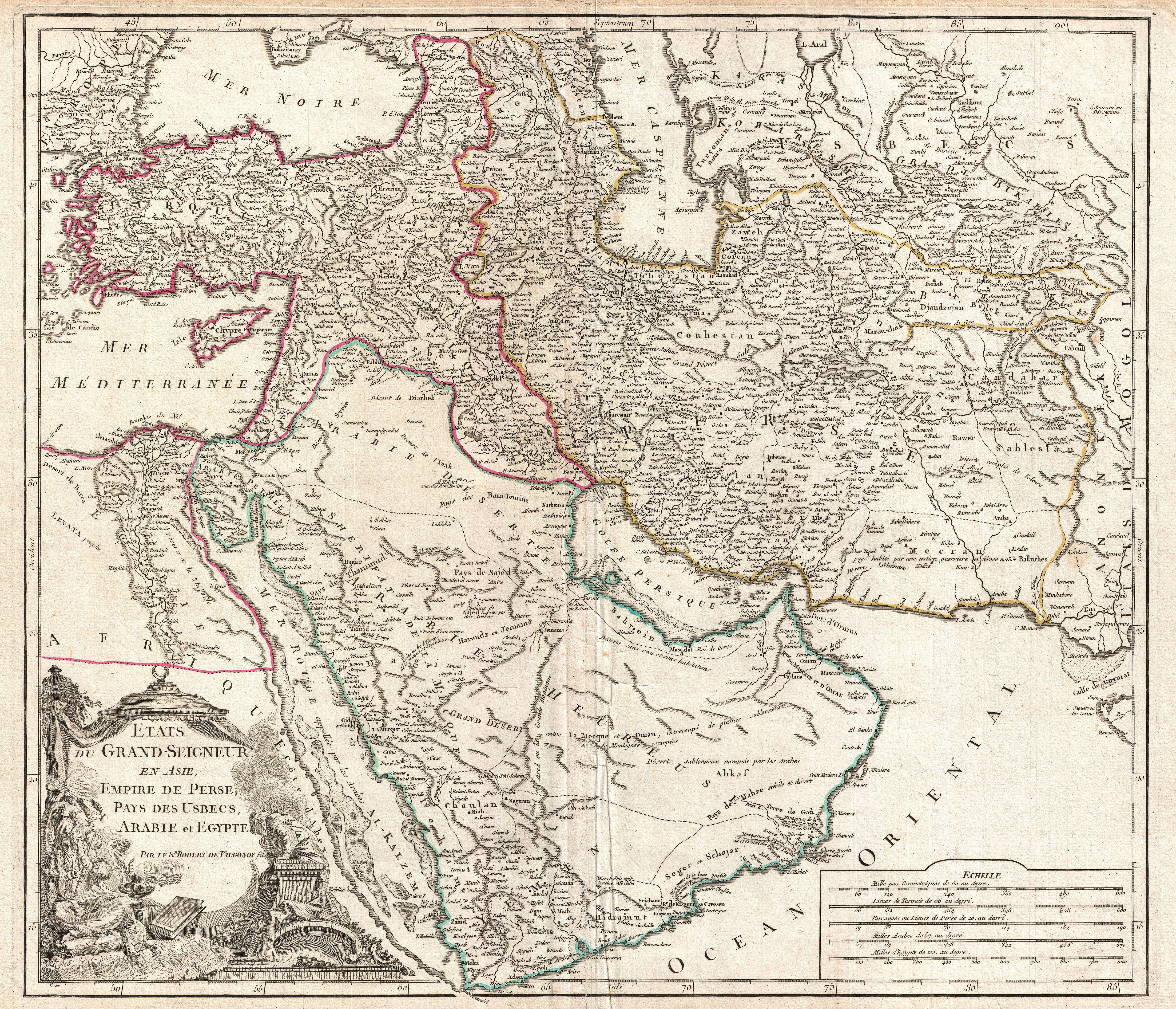
English: This is Robert de Vaugondy’s spectacular 1753 map of the Ottoman Empire. Vaugondy maps the empire at its height, with territory spanning from the Black Sea to the southernmost extension of Arabia and west, inclusive of Persia, as far as the Mongol Empire of India. Includes the modern day nations of Turkey, Egypt, Saudi Arabia, Oman, Yemen, the United Arab Emirates, Iran, Iraq, Kuwait, Israel, Palestine, Jordan, Syria, Lebanon, Armenia, Azerbaijan, Georgia, and parts of Afghanistan, Pakistan, India, Uzbekistan, and Greece. Vaugondy employs all of the latest geographical information of the time incorporating both French and transliterations Arabic place names. This map offers splendid detail throughout inclusive of undersea shoals and reefs in the Red Sea and Persian Gulf, mountain ranges, lakes, rivers, and historical sites. A highly decorative title cartouche showing an Ottoman prince appears in the lower left quadrant. Five distance scales are in the lower right. Drawn by Robert de Vaugondy in 1753 and published in the 1757 issue of his Atlas Universal . |
|||||
| تاریخ | ۱۷۵۳ (undated) | |||||
| اؤلچولر | بلندی: ۱۹٫۵ اینچ (۴۹٫۵ سانتیمتر)؛ عرض: ۲۲٫۰ اینچ (۵۵٫۸ سانتیمتر) | |||||
| آیدی |
Geographicus link: TurkeyArabiaPersia-vaugondy-1753 |
|||||
| منبع/عکاس |
Vaugondy, R., Atlas Universel, (Paris) 1784.
|
|||||
| ایجازه (فایلین تکرار ایستیفادهسی) |
|
|||||
فايل گئچمیشی
فايلین اولکی وئرسیياسینی گؤرمک اۆچون گۆن/تاریخ بؤلمهسیندهکی تاریخلری تێقلايین.
| تاریخ/واخت | کیچیک عکس | اؤلچولر | ایشلدن | باخیش | |
|---|---|---|---|---|---|
| ایندیکی | ۲۵ مارس ۲۰۱۱، ساعت ۰۳:۰۳ | | ۵٬۰۰۰ در ۴٬۲۹۳ (۶٫۹ مگابایت) | BotMultichillT | {{subst:User:Multichill/Geographicus |link=http://www.geographicus.com/P/AntiqueMap/TurkeyArabiaPersia-vaugondy-1753 |product_name=1753 Vaugondy Map of Persia, Arabia and Turkey |map_title=Etats du Grand-Seigneur en Asie, Empire de Perse, Pays des Usbecs, |
فايل ایشلدمهسی
آشاغیداکی صحیفه بو فایلا باغلانیر
فایلین باشاباش ایشلنیلمهسی
بو فایل آشاغی داکی آیری ویکی لرده ایشلَنیر:
- ba.wikipedia.org-ده ایشلنمهسی
- bs.wikipedia.org-ده ایشلنمهسی
- en.wikipedia.org-ده ایشلنمهسی
- hr.wikipedia.org-ده ایشلنمهسی
- hu.wikipedia.org-ده ایشلنمهسی
- ru.wikipedia.org-ده ایشلنمهسی
- sh.wikipedia.org-ده ایشلنمهسی
- uz.wikipedia.org-ده ایشلنمهسی