
فایل:Yemen division 2011-10-23.svg

حجم پیشنمایش PNG این SVG file:۸۰۰ × ۵۲۲ پیکسل آیری کیفیتلر: ۳۲۰ × ۲۰۹ پیکسل | ۶۴۰ × ۴۱۸ پیکسل | ۱٬۰۲۴ × ۶۶۹ پیکسل | ۱٬۲۸۰ × ۸۳۶ پیکسل | ۲٬۵۶۰ × ۱٬۶۷۱ پیکسل | ۱٬۵۲۴ × ۹۹۵ پیکسل.
فایلین اصلی (SVG فایلی، ۱٬۵۲۴ × ۹۹۵ پیکسئل، فایلین اؤلچوسو: ۱٫۰۷ مگابایت)
قیساسی
| آچیقلاما |
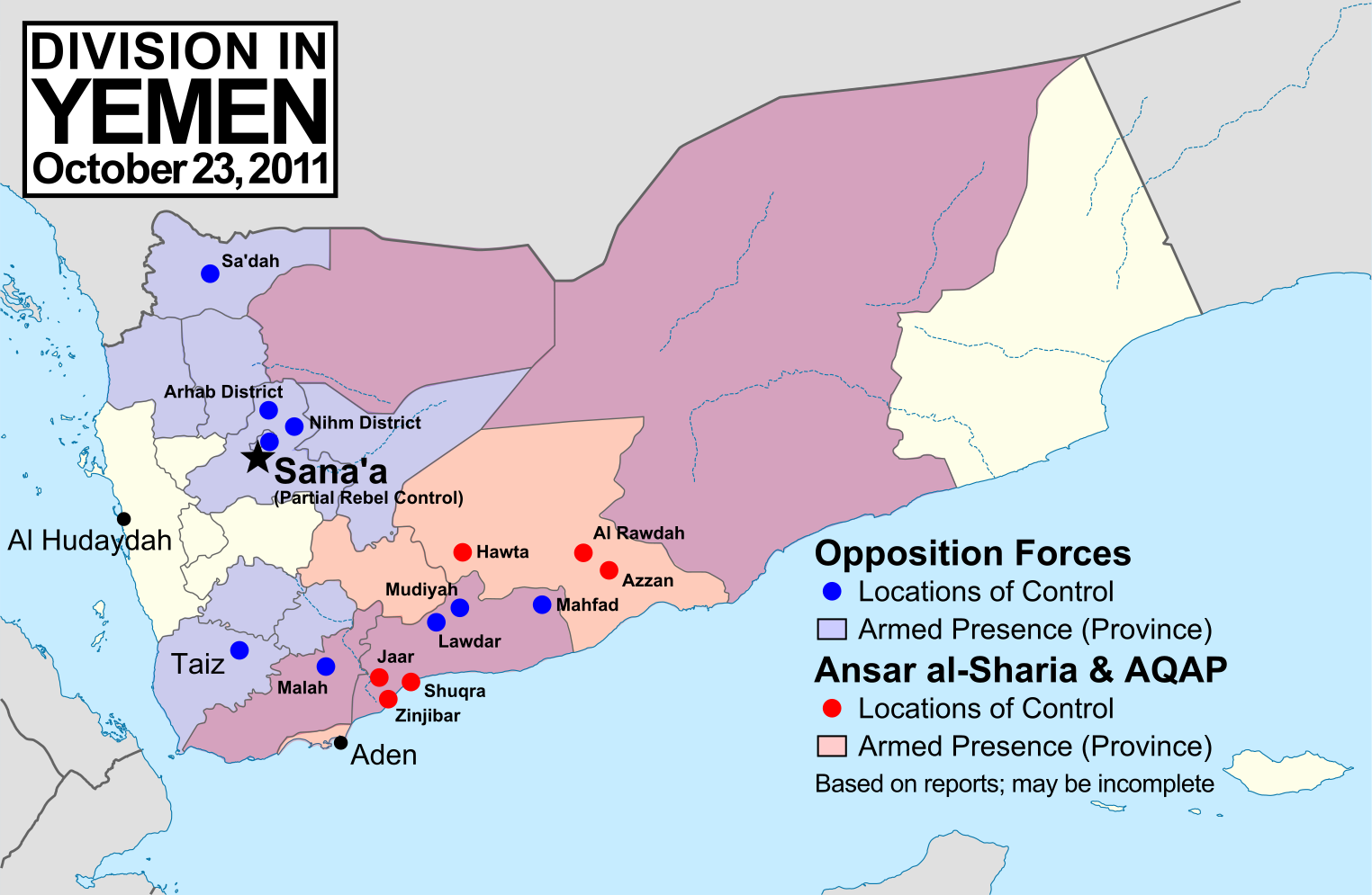
English: Note: This map depicts the situation in October 2011. For an updated version, see File:Yemen division 2012-3-11.svg. Map of division in Yemen as of October 23, 2011. Map is limited to information from English-language media, and therefore may be incomplete. Red represents Islamist extremists under Ansar al-Sharia and/or Al-Qaeda in the Arabian Peninsula (AQAP). Blue represents all other non-government armed groups which are hostile or possibly hostile to the government of President Ali Abdullah Saleh, including military defectors, pre-existing rebel groups, and local and kinship-based militias (including those which have worked together with the government against Ansar al-Sharia). Dots indicate specific locations cited by the media as being currently controlled by said groups, while shading indicates provinces (governorates) from which an open armed presence or attacks by said groups have been reported since the uprising began. Purple shading indicates that Ansar al-Sharia/AQAP and other non-government forces both have armed presences reported within the province, while white indicates that no rebel activity has been reported (implying that Saleh's government still fully maintains state power there). Note that unarmed protests are not depicted, and would extend well into the white areas of the map. See also: File:Yemen division 2011-7-7.svg |
| تاریخ | |
| قایناق | یوکلهیهنین اؤز ایشی, starting from File:Yemen_location_map.svg by user NordNordWest. Information comes from a variety of online news sources, especially the Yemen Post and Critical Threats. |
| یازار | GeoEvan |
| ایجازه (فایلین تکرار ایستیفادهسی) |
Modified version of file from Political Geography Now blog, re-licensed here to allow for commercial use. Please credit "Political Geography Now" with link to http://www.polgeonow.com. |
لیسانس
من، صاحب حقوق قانونی این اثر، به این وسیله این اثر را تحث اجازهنامهٔ ذیل منتشر میکنم:
بو فایل کریتیو کامانز مجوز ایله Attribution-Share Alike 3.0 اویغونلاشمامیش یاییملانیبدیر.
- سیزین ایجازه نیز وار دیر:
- بؤلۆشمک – اثرین کپی، پایلاشماق و چاتدیرماسی اوچون
- تلفیق ائت – اثرین توتوشدورماسی اوچون
- آشاغی داکی شرایطله:
- تخصیص – اثری مؤلف و یا لیسئنزییالی طرفیندن گؤستریلدیی کیمی ایستیناد ائتملیسینیز (آنجاق سنی دستکلدیینی و یا اثردن ایستیفاده ائتمیینیزی تکلیف ائتمملیسینیز).
- بیرگه پایلاشیم – اگر بو اثرده دَییشدیرمه، چؤندرمه، یا دا کؤکدن دوزلتمه ائتسز، اله گلمیش اثری یالنیز بیر ائشیت یوخسا اوخشار بیر مجوزین آلتیندا یاییملایابیلرسینیز .
فايل گئچمیشی
فايلین اولکی وئرسیياسینی گؤرمک اۆچون گۆن/تاریخ بؤلمهسیندهکی تاریخلری تێقلايین.
| تاریخ/واخت | کیچیک عکس | اؤلچولر | ایشلدن | باخیش | |
|---|---|---|---|---|---|
| ایندیکی | ۱۹ نوْوامبر ۲۰۱۱، ساعت ۱۵:۱۵ | | ۱٬۵۲۴ در ۹۹۵ (۱٫۰۷ مگابایت) | GeoEvan | Corrections per English Wikipedia talk page (http://en.wikipedia.org/wiki/File_talk:Yemen_division_2011-10-23.svg): Added Sa'dah city to opposition controlled locations; changed "Islamist Militants" label to "Ansar a-Sharia & AQAP" so as to exclude the un |
| ۲۵ اوْکتوبر ۲۰۱۱، ساعت ۱۹:۴۱ |  | ۱٬۵۲۴ در ۹۹۵ (۱٫۰۴ مگابایت) | GeoEvan | =={{int:filedesc}}== {{Information |description={{en|1=Map of division in Yemen as of October 23, 2011. Map is limited to information from from English-language media, and therefore may be incomplete. Red represents Islamist militants (Ansar al-Sharia and |
فايل ایشلدمهسی
آشاغیداکی صحیفه بو فایلا باغلانیر
فایلین باشاباش ایشلنیلمهسی
بو فایل آشاغی داکی آیری ویکی لرده ایشلَنیر:
- ca.wikipedia.org-ده ایشلنمهسی
- en.wikipedia.org-ده ایشلنمهسی
- hy.wikipedia.org-ده ایشلنمهسی
- it.wikipedia.org-ده ایشلنمهسی
- ka.wikipedia.org-ده ایشلنمهسی
- pl.wikipedia.org-ده ایشلنمهسی
- pt.wikipedia.org-ده ایشلنمهسی
- ru.wikipedia.org-ده ایشلنمهسی
- www.wikidata.org-ده ایشلنمهسی