اشتون-آندر-لاین
ظاهر
| Ashton-under-Lyne | |
|---|---|
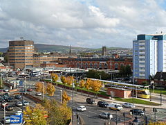
 Ashton-under-Lyne town centre (to left: Tameside Metropolitan Borough building, demolished in Summer 2016) | |
| جمعیت | ۴۵٬۱۹۸ (2011 Census) |
| • Density | 12,374 per mi² (4,777 per km²) |
| OS grid reference | SJ931997 |
| • لندن | ۱۶۰ mi (۲۵۷ km) SSE |
| Metropolitan borough | |
| Metropolitan county | |
| Region | |
| اؤلکه | England |
| موستقیل دوولت | United Kingdom |
| Post town | Ashton-under-Lyne |
| Postcode district | OL5–OL7 |
| تیلفون کودو | 0161 |
| Ambulance | North West |
| UK Parliament | |
اشتون-آندر-لاین (اینگیلیسیجه: Ashton-under-Lyne) بریتانیادا بیر یاشاییش منطقهسیدیر سوْن نۆفوس تخمینلرینه گؤره 45198 نفر دیر. بۇ شهر اینگیلیس اؤلکهسینده یئرلشیب.

