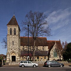
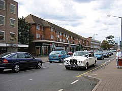
اشفورد، ساری
ظاهر
| Ashford | |
|---|---|
 St Matthew's C of E parish church | |
 Church Road | |
| Area | ۶٫۷۱ km2 (۲٫۵۹ sq mi) |
| جمعیت | ۲۷٬۳۸۲ (2011 census)[۱] |
| • Density | ۴٬۰۸۱/km2 (۱۰٬۵۷۰/sq mi) |
| OS grid reference | TQ065715 |
| Civil parish |
|
| District | |
| Shire county | |
| Region | |
| اؤلکه | England |
| موستقیل دوولت | United Kingdom |
| Post town | ASHFORD |
| Postcode district | TW15 |
| تیلفون کودو | 017840 |
| UK Parliament | |
اشفورد، ساری (اینگیلیسیجه: Ashford, Surrey) بریتانیادا بیر یاشاییش منطقهسیدیر سوْن نۆفوس تخمینلرینه گؤره 27382 نفر دیر. بۇ شهر اینگیلیس اؤلکهسینده یئرلشیب.
- ^ Key Statistics; Quick Statistics: Population Density United Kingdom Census 2011 Office for National Statistics Ashford makes up 2011 lower output areas Spelthorne 003, 005 and 006. Note: the towns and villages in Spelthorne have one ward each which covers part of a neighbouring town or village. For example, Ashford is two wards and part of a third ward (see Government). Retrieved 21 November 2013

