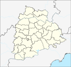
کرچیپالی
ظاهر
Kerchipally | |
|---|---|
کند | |
| موختصاتلار: 17°25′42″N 79°02′44″E / 17.428425°N 79.045439°Eموختصات: 17°25′42″N 79°02′44″E / 17.428425°N 79.045439°E | |
| Country | هیندوستان |
| State | تلانقانا |
| Region | تلانقانا |
| District | Yadadri Bhuvanagiri |
| Mandal | Valigonda |
| اوجالیق | ۲۹۰ m (۹۵۰ ft) |
| دیللر | |
| • رسمی | تلوقو دیلی |
| ساعات قورشاغی | یوتیسی +5:30 (IST) |
| PIN | 508112 |
| Climate | hot (Köppen) |
کرچیپالی (اینگیلیسجه:Kerchipally) هیندوستان اؤلکهسینین تلانقانا ایالتینده بیر کند دیر. دنیز سوُلاری سَویهسیندن ۲۹۰ متر یۇکسکلیکده یئر آلیب. بۇ کنده تلوقو دیلی دانیشیلیر.
قایناقلار
[دَییشدیر]| بو هیندوستان- ایله باغلی مقاله، بیر قارالاما مقاله دیر. بونو گئنیشلندیرمکله ویکیپدیایا کؤمک ائده بیلرسینیز. |


