ایناراجان، قوام
ظاهر
Inarajan Inalåjan | |
|---|---|
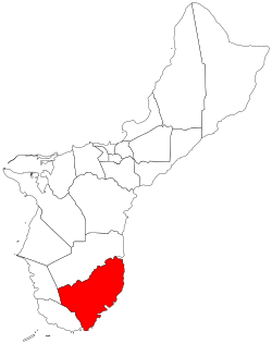
 Location of Inarajan within the Territory of Guam. | |
| Country | United States |
| Territory | Guam |
| ایداره | |
| • Mayor | Doris Flores Lujan (D) |
| جمعیت (2010)[۱] | |
| • جمع | ۲٬۲۷۳ |
| ساعات قورشاغی | یوتیسی +10 (ChST) |
Inarajan Village | |
| لوآ خطاسیماژول:Location_map-ین 522-جی/جو خطینده: Unable to find the specified location map definition: "Module:Location map/data/Guam" does not exist. | |
| یئر | Rte. 4 |
| ساحه | ۴۹ acre (۲۰ ha) |
| Built | ۱۹۰۱ |
| معمار | Cruz, Jose Duena; Luttrull, A.I. |
| NRHP ایستینادی # | 77001569[۲] |
| NRHP-ه علاوه اولدو | November 7, 1977 |
| Historical population | |||
|---|---|---|---|
| Census | Pop. | %± | |
| 1960 | ۱٬۷۳۰ | — | |
| 1970 | ۱٬۸۹۷ | ۹٫۷% | |
| 1980 | ۲٬۰۵۹ | ۸٫۵% | |
| 1990 | ۲٬۴۶۹ | ۱۹٫۹% | |
| 2000 | ۳٬۰۵۲ | ۲۳٫۶% | |
| 2010 | ۲٬۲۷۳ | −۲۵٫۵% | |
| Source: | |||
ایناراجان (اینگیلیسجه: Inarajan, Guam) آمریکانین گوام ایالتینده یئرلشن بیر کند .
قایناقلار
[دَییشدیر]- ^ 2010 Guam Statistical Yearbook. آرشیولنیب اصلی نۆسخهدن on 2014-07-23. (4.3 MB), (rev. 2011)
- ^ National Park Service (۲۰۱۰-۰۷-۰۹). National Register Information System. National Register of Historic Places. National Park Service.
