اینورمر
ظاهر
Invermere | |
|---|---|
| District of Invermere[۱] | |
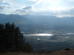
 Invermere, British Columbia, with Mount Nelson in the distance | |
 Location of Invermere, British Columbia | |
| موختصاتلار: 50°30′30″N 116°01′49″W / 50.50833°N 116.03028°W | |
| Country | Canada |
| Province | British Columbia |
| Region | East Kootenay |
| Incorporated | 1951 |
| ایداره | |
| • Governing body | Invermere Council |
| • MP | Rob Morrison |
| • MLA | Doug Clovechok |
| اراضی | |
| • توپراق | ۱۰٫۷۳ km2 (۴٫۱۴ sq mi) |
| اوجالیق | ۸۵۹ m (۲٬۸۱۸ ft) |
| جمعیت (2016)[۲] | |
| • جمع | ۳٬۳۹۱ |
| • سیخلیق | ۳۱۵٫۹/km2 (۸۱۸/sq mi) |
| ساعات قورشاغی | یوتیسی -7 (Mountain Standard (MST)) |
| • یای (DST) | یوتیسی -6 (Mountain Daylight (MDT)) |
| Postal code span | V0A 1K0, V0A 1K7 |
| تیلفون کودلاری | 250 / 778 / 236 |
| Highways | Invalid type: Hwy Invalid type: Hwy |
| Waterways | Columbia River, Windermere Lake |
| وئب سایت | Town of Invermere |
اینورمر (اینگیلیسجه: Invermere) آمریکادا یئرلشن بیر یاشاییش منطقهسی. ۲۰۱۱-جی وئریلن معلوماتا اهالیسینین سایی ۳٬۳۹۱ نفر ایدی.
قایناقلار
[دَییشدیر]- ^ British Columbia Regional Districts, Municipalities, Corporate Name, Date of Incorporation and Postal Address. British Columbia Ministry of Communities, Sport and Cultural Development. آرشیولنیب اصلی نۆسخهدن on July 13, 2014. یوْخلانیلیبNovember 2, 2014.
- ^ Population and dwelling counts, for Canada, provinces and territories, and census subdivisions (municipalities), 2016 and 2011 censuses – 100% data (British Columbia). Statistics Canada (August 28, 2017). یوْخلانیلیبDecember 31, 2017.
