ترمونتون، یوتا
ظاهر
Tremonton, Utah | |
|---|---|
 Diner in the entrance of Tremonton at the junction of Interstate 15 and Interstate 84 in Utah | |
| Motto(s): "A friendly and progressive place" "City with a future | |
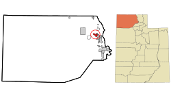
 Location in Box Elder County and the state of Utah | |
 Location of Utah in the United States | |
| موختصاتلار: 41°42′34″N 112°10′26″W / 41.70944°N 112.17389°Wموختصات: 41°42′34″N 112°10′26″W / 41.70944°N 112.17389°W | |
| Country | United States |
| State | Utah |
| County | Box Elder |
| Settled | 1888 |
| Incorporated | January 6, 1906 |
| City | May 6, 1918 |
| تاسیس ائدن | John Petty |
| آدلاندیرما سببی | Tremont, Illinois |
| اراضی | |
| • جمع | ۸٫۰۱ sq mi (۲۰٫۷۵ km2) |
| • توپراق | ۸٫۰۱ sq mi (۲۰٫۷۵ km2) |
| • سو | ۰٫۰۰ sq mi (۰٫۰۰ km2) |
| اوجالیق | ۴٬۳۲۴ ft (۱٬۳۱۸ m) |
| جمعیت (2010) | |
| • جمع | ۷٬۶۴۷ |
| • تخمین (2018) | ۸٬۸۸۲ |
| • سیخلیق | ۱٬۱۰۸٫۴۵/sq mi (۴۲۷٫۹۵/km2) |
| ساعات قورشاغی | یوتیسی -7 (Mountain (MST)) |
| • یای (DST) | یوتیسی -6 (MDT) |
| ZIP code | 84337 |
| تیلفون کودلاری | 435 |
| FIPS code | 49-77120[۳] |
| GNIS feature ID | 1433664 |
| وئب سایت | www |
ترمونتون (اینگیلیسجه: Tremonton, Utah) آمریکانین یوتا ایالتینده یئرلشن بیر شهر. بۇ یاشاییش یئرین اساسی ۱۸۸۸ -جی ایلده قۇیولموشدور. ۲۰۱۸-جی وئریلن معلوماتا اهالیسینین سایی ۸۸۸۲ نفر ایدی.
قایناقلار
[دَییشدیر]- ^ 2018 U.S. Gazetteer Files. United States Census Bureau. یوْخلانیلیبFeb 16, 2020.
- ^ U.S. Geological Survey Geographic Names Information System: Tremonton
- ^ American FactFinder. United States Census Bureau. یوْخلانیلیب2008-01-31.
