دولورز، کولورادو
ظاهر
Town of Dolores, Colorado | |
|---|---|
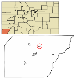
 Location of Dolores in Montezuma County, Colorado. | |
| موختصاتلار: 37°28′26″N 108°29′59″W / 37.473990°N 108.499824°Wموختصات: 37°28′26″N 108°29′59″W / 37.473990°N 108.499824°W[۲] | |
| Country | |
| State | |
| County | Montezuma County[۱] |
| Incorporated | July 19, 1900[۳] |
| ایداره | |
| • نووع | Statutory Town |
| اراضی | |
| • جمع | ۰٫۷۳ sq mi (۱٫۸۹ km2) |
| • توپراق | ۰٫۷۳ sq mi (۱٫۸۹ km2) |
| • سو | ۰٫۰۰ sq mi (۰٫۰۰ km2) |
| اوجالیق | ۶٬۹۳۶ ft (۲٬۱۱۴ m) |
| جمعیت (2010) | |
| • جمع | ۹۳۶ |
| • تخمین (2018) | ۹۵۸ |
| • سیخلیق | ۱٬۳۶۹٫۵۱/sq mi (۵۲۸٫۸۶/km2) |
| ساعات قورشاغی | یوتیسی -7 (MST) |
| • یای (DST) | یوتیسی -6 (MDT) |
| ZIP code[۶] | 81323 |
| تیلفون کودلاری | 970 |
| FIPS code | 08-20770 |
| GNIS feature ID | 0202607 |
| وئب سایت | www |
دولورز (اینگیلیسجه: Dolores, Colorado) آمریکانین کولورادو ایالتینده یئرلشن بیر شهر . ۲۰۱۸-جی وئریلن معلوماتا اهالیسینین سایی ۹۵۸ نفر ایدی.
قایناقلار
[دَییشدیر]- ^ Active Colorado Municipalities. State of Colorado, Department of Local Affairs. آرشیولنیب اصلی نۆسخهدن on 2009-12-12. یوْخلانیلیب2007-09-01.
- ^ 2014 U.S. Gazetteer Files: Places. United States Census Bureau (July 1, 2014). یوْخلانیلیبJanuary 5, 2015.
- ^ Colorado Municipal Incorporations. State of Colorado, Department of Personnel & Administration, Colorado State Archives (2004-12-01). یوْخلانیلیب2007-09-02.
- ^ 2016 U.S. Gazetteer Files. United States Census Bureau. یوْخلانیلیبJul 25, 2017.
- ^ US Board on Geographic Names. United States Geological Survey (2007-10-25). یوْخلانیلیب2008-01-31.
- ^ ZIP Code Lookup (JavaScript/HTML). United States Postal Service. آرشیولنیب اصلی نۆسخهدن on November 4, 2010. یوْخلانیلیبSeptember 8, 2007.

