وزتویل، نیوجرسی
ظاهر
Westville, New Jersey | |
|---|---|
| Borough of Westville | |
| Motto(s): "The Gateway to South Jersey"[۱] | |
 Map of Westville highlighted within Gloucester County. Inset: Location of Gloucester County in New Jersey. | |
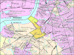
 Census Bureau map of Westville, New Jersey | |
| موختصاتلار: 39°52′08″N 75°07′54″W / 39.868922°N 75.131584°Wموختصات: 39°52′08″N 75°07′54″W / 39.868922°N 75.131584°W[۲] | |
| Country | |
| State | |
| County | |
| Incorporated | April 28, 1914 |
| ایداره | |
| • نووع | Borough |
| • اورقانی | Borough Council |
| • Mayor | Russell W. Welsh Jr. (D, term ends December 31, 2022)[۳] |
| • Administrator | Ryan J. Giles[۴] |
| • Municipal clerk | Ryan J. Giles |
| اراضی | |
| • جمع | ۱٫۳۷۸ sq mi (۳٫۵۶۸ km2) |
| • توپراق | ۱٫۰۲۴ sq mi (۲٫۶۵۲ km2) |
| • سو | ۰٫۳۵۴ sq mi (۰٫۹۱۶ km2) 25.66% |
| مساحت درجهسی | 463rd of 566 in state 21st of 24 in county |
| اوجالیق | ۲۳ ft (۷ m) |
| جمعیت | |
| • جمع | ۴٬۲۸۸ |
| • تخمین (2018) | ۴٬۱۶۳ |
| • درجهسی | 400th of 566 in state 17th of 24 in county[۸] |
| • سیخلیق | ۴٬۱۸۷٫۰/sq mi (۱٬۶۱۶٫۶/km2) |
| • سیخلیق درجهسی | 143rd of 566 in state 2nd of 24 in county |
| ساعات قورشاغی | یوتیسی −05:00 (Eastern (EST)) |
| • یای (DST) | یوتیسی −04:00 (Eastern (EDT)) |
| ZIP Code | |
| Area code | 856[۱۱] |
| FIPS code | 3401580120[۱۲][۱۳] |
| GNIS feature ID | 0885440[۱۴] |
| وئب سایت | www |
وزتویل (اینگیلیسجه: Westville, New Jersey) آمریکانین نیوجرسی ایالتینده یئرلشن بیر کند. بۇ یاشاییش یئرین اساسی ۱۹۱۴ -جو ایلده قۇیولموشدور. ۲۰۱۸-جی وئریلن معلوماتا اهالیسینین سایی ۴۱۶۳ نفر ایدی.
قایناقلار
[دَییشدیر]- ^ Transportation, Westville, New Jersey. Accessed November 1, 2014. "Westville was called the Gateway to South Jersey because Delsea Drive, Broadway and Crown Point Road all lead to important spots in South Jersey."
- ^ US Gazetteer files: 2010, 2000, and 1990, United States Census Bureau. Accessed September 4, 2014.
- ^ 2020 New Jersey Mayors Directory, New Jersey Department of Community Affairs. Accessed February 1, 2020.
- ^ Borough Department Directory, Borough of Westville. Accessed November 11, 2019.
- ^ 2010 Census Gazetteer Files: New Jersey County Subdivisions, United States Census Bureau. Accessed May 21, 2015.
- ^ U.S. Geological Survey Geographic Names Information System: Borough of Westville, Geographic Names Information System. Accessed March 14, 2013.
- ^ Profile of General Demographic Characteristics: 2010 for Westville borough, New Jersey Department of Labor and Workforce Development. Accessed November 8, 2012.
- ^ GCT-PH1 Population, Housing Units, Area, and Density: 2010 - State -- County Subdivision from the 2010 Census Summary File 1 for New Jersey[دائمی اولو باغلانتیلی], United States Census Bureau. Accessed November 8, 2012.
- ^ Look Up a ZIP Code for Westville, NJ, United States Postal Service. Accessed November 8, 2012.
- ^ Zip Codes, State of New Jersey. Accessed September 1, 2013.
- ^ Area Code Lookup - NPA NXX for Westville, NJ, Area-Codes.com. Accessed September 1, 2013.
- ^ American FactFinder Archived 2008-05-21 at the Wayback Machine., United States Census Bureau. Accessed September 4, 2014.
- ^ Geographic codes for New Jersey Archived 2019-06-04 at the Wayback Machine., Missouri Census Data Center. Accessed September 1, 2019.
- ^ US Board on Geographic Names, United States Geological Survey. Accessed September 4, 2014.


