بارنز، لندن
ظاهر
| Barnes | |
|---|---|
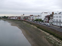
 Barnes riverside from the bridge | |
Location within لندن بزرگ | |
| Area | ۴٫۵۰ km2 (۱٫۷۴ sq mi) |
| جمعیت | ۲۱٬۲۱۸ (Barnes and Mortlake and Barnes Common wards 2011)[۲] |
| • Density | ۴٬۷۱۵/km2 (۱۲٬۲۱۰/sq mi) |
| OS grid reference | TQ225765 |
| • چرینق کراس | ۵٫۸ mi (۹٫۳ km)* ENE |
| London borough | |
| شهرستان | Greater London |
| Region |
|
| اؤلکه | England |
| موستقیل دوولت | United Kingdom |
| Post town | LONDON |
| Postcode district | SW13 |
| تیلفون کودو | 020 |
| Police | Metropolitan |
| Fire | سازمان آتشنشانی لندن |
| Ambulance | London |
| UK Parliament | |
| London Assembly | |
بارنز، لندن (اینگیلیسیجه: Barnes, London) بریتانیادا بیر یاشاییش منطقهسیدیر بۇ شهر اینگیلیس اؤلکهسینده یئرلشیب.
گؤرونتولر
[دَییشدیر]بیرده باخ
[دَییشدیر]قایناقلار
[دَییشدیر]- ^ Census Information Scheme (2012). 2011 Census Ward Population Estimates. Greater London Authority. یوْخلانیلیب30 January 2013.
- ^ Key Statistics; Quick Statistics: Population Density [۱] Office for National Statistics
| بو شهرلر ایله باغلی مقاله، بیر قارالاما مقاله دیر. بونو گئنیشلندیرمکله ویکیپدیایا کؤمک ائده بیلرسینیز. |


