بلفاست
ظاهر
| Belfast | |
|---|---|
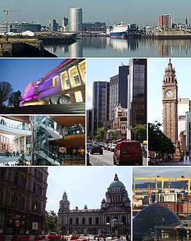
 Skyline and buildings throughout the City of Belfast | |
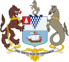
 Coat of arms with motto "Pro Tanto Quid Retribuamus" (Latin: "What shall we give in return for so much") | |
| لوآ خطاسیماژول:Location_map-ین 522-جی/جو خطینده: Unable to find the specified location map definition: "Module:Location map/data/Northern Ireland" does not exist. | |
| Area | ۳۵٫۳۲ sq mi (۹۱٫۵ km2) |
| جمعیت | City of Belfast: 333,001 (2016)[۱] Urban Area: 483,418 (2016)[۲] Metropolitan area: 671,559 (2011)[۳] |
| Irish grid reference | شابلون:Iem4ibx |
| District | |
| County | |
| اؤلکه | Northern Ireland |
| موستقیل دوولت | United Kingdom |
| Post town | BELFAST |
| Postcode district | BT1–BT17, BT29 (part), BT36 (part), BT58 |
| تیلفون کودو | 028 |
| Police | Northern Ireland |
| Fire | Northern Ireland |
| Ambulance | Northern Ireland |
| UK Parliament | |
| NI Assembly | |
| Website | www.belfastcity.gov.uk |
بلفاست (اینگیلیسیجه: Belfast) بریتانیادا بیر یاشاییش منطقهسیدیر بۇ شهر قوزئی ایرلند اؤلکهسینده یئرلشیب.
گؤرونتولر
[دَییشدیر]بیرده باخ
[دَییشدیر]قایناقلار
[دَییشدیر]- ^ Belfast City Council. آرشیولنیب اصلی نۆسخهدن on 2018-02-10. یوْخلانیلیب22 February 2016.
- ^ The UK's major urban areas Office for National Statistics (Urban area of Belfast and connected settlements, Table 3.1, page 47)
- ^ Belfast Metropolitan Area Plan. آرشیولنیب اصلی نۆسخهدن on 2017-11-07. یوْخلانیلیب11 April 2018.
| بو شهرلر ایله باغلی مقاله، بیر قارالاما مقاله دیر. بونو گئنیشلندیرمکله ویکیپدیایا کؤمک ائده بیلرسینیز. |


